| [1] |
SAATCHI S S, HARRIS N L, BROWN S, et al. Benchmark map of forest carbon stocks in tropical regions across three continents[J]. Proceedings of the National Academy of Sciences of the United States of America, 2011,108(24):9899-9904.
doi: 10.1073/pnas.1019576108
|
| [2] |
PAN Yude, BIRDSEY R A, FANG Jingyun, et al. A large and persistent carbon sink in the world’s forests[J]. Science, 2011,333(6045):988-993.
doi: 10.1126/science.1204588
|
| [3] |
LETOAN T, QUEGAN S, DAVIDSON M W J, et al. The BIOMASS mission: Mapping global forest biomass to better understand the terrestrial carbon cycle[J]. Remote Sensing of Environment, 2011,115(11):2850-2860.
doi: 10.1016/j.rse.2011.03.020
|
| [4] |
ESA. Report for mission selection: Biomass[R]. Noordwijk, The Netherlands: ESA, 2012.
|
| [5] |
HO TONG MINHD, LE TOAN T, ROCCA F, et al. Relating P-band synthetic aperture radar tomography to tropical forest biomass[J]. IEEE Transactions on Geoscience and Remote Sensing, 2014,52(2):967-979.
doi: 10.1109/TGRS.2013.2246170
|
| [6] |
HO TONG MINH D, LE TOAN T, ROCCA F, et al. SAR tomography for the retrieval of forest biomass and height: cross-validation at two tropical forest sites in French Guiana[J]. Remote Sensing of Environment, 2016,175:138-147.
doi: 10.1016/j.rse.2015.12.037
|
| [7] |
DUBOIS-FERNANDEZ P C, LE TOAN T, DANIEL S, et al. The TropiSAR airborne campaign in french guiana: Objectives, description, and observed temporal behavior of the backscatter signal[J]. IEEE Transactions on Geoscience and Remote Sensing, 2012,50(8):3228-3241.
doi: 10.1109/TGRS.2011.2180728
|
| [8] |
REIGBER A, MOREIRA A. First demonstration of airborne SAR tomography using multibaseline L-band data[J]. IEEE Transactions on Geoscience and Remote Sensing, 2000,38(5):2142-2152.
doi: 10.1109/36.868873
|
| [9] |
GINI F, LOMBARDINI F, MONTANARI M. Layover solution in multibaseline SAR interferometry[J]. IEEE Transactions on Aerospace and Electronic systems, 2002,38(4):1344-1356.
doi: 10.1109/TAES.2002.1145755
|
| [10] |
FREY O, MAGNARD C, RUEGG M, et al. Focusing of airborne synthetic aperture radar data from highly nonlinear flight tracks[J]. IEEE Transactions on Geoscience and Remote Sensing, 2009,47(6):1844-1858.
doi: 10.1109/TGRS.2008.2007591
|
| [11] |
TEBALDINI S, NAGLER T, ROTT H, et al. Imaging the internal structure of an alpine glacier via l-band airborne SAR tomography[J]. IEEE Transactions on Geoscience and Remote Sensing, 2016,54(12):7197-7209.
doi: 10.1109/TGRS.2016.2597361
|
| [12] |
TEBALDINI S, GUARNIERI A M. On the role of phase stability in SAR multibaseline applications[J]. IEEE Transactions on Geoscience and Remote Sensing, 2010,48(7):2953-2966.
doi: 10.1109/TGRS.2010.2043738
|
| [13] |
TEBALDINI S, ROCCA F, D’ALESSANDRO M M, et al. Phase calibration of airborne tomographic SAR data via phase center double localization[J]. IEEE Transactions on Geoscience and Remote Sensing, 2016,54(3):1775-1792.
doi: 10.1109/TGRS.2015.2488358
|
| [14] |
DINH H T M, TEBALDINI S, ROCCA F, et al. Ground-based array for tomographic imaging of the tropical forest in P-band[J]. IEEE Transactions on Geoscience and Remote Sensing, 2013,51(8):4460-4472.
doi: 10.1109/TGRS.2013.2246795
|
| [15] |
MINH D H T, TEBALDINI S, ROCCA F, et al. Vertical structure of P-band temporal decorrelation at the paracou forest: results from TropiScat[J]. IEEE Geoscience and Remote Sensing Letters, 2014,11(8):1438-1442.
doi: 10.1109/LGRS.2013.2295165
|
| [16] |
BAI Yu, TEBALDINI S, MINH D H T, et al. An empirical study on the impact of changing weather conditions on repeat-pass SAR tomography[J]. IEEE Journal of Selected Topics in Applied Earth Observations and Remote Sensing, 2018,11(10):3505-3511.
doi: 10.1109/JSTARS.4609443
|
| [17] |
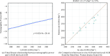
YANG X, D’ALESSANDRO M M, TEBALDINI S, et al. Relating SAR tomography to tropical forest biomass via LiDAR data[C]// Proceedings of IGARSS 2018—2018 IEEE International Geoscience and Remote Sensing Symposium. Valencia:IEEE, 2018: 9034-9037.
|

 ),Xinwei YANG1,2,Yu BAI1,3,Mauro Mariotti D’ALESSANDRO1,Mingsheng LIAO2,Wen YANG3