
Journal of Geodesy and Geoinformation Science ›› 2021, Vol. 4 ›› Issue (3): 38-48.doi: 10.11947/j.JGGS.2021.0304
• Special Issue • Previous Articles Next Articles
Xiaochen WANG1( ),Hongchao MA1(),Liang ZHANG2,Zhan CAI3,Haichi MA1
Received:2020-09-15
Accepted:2021-01-15
Online:2021-09-20
Published:2021-10-09
Contact:
Hongchao MA
E-mail:xchwang@whu.edu.cn;hchma@whu.edu.cn
About author:Xiaochen WANG (1998—), male, master, majors in airborne LiDAR point cloud and waveform data processing. E-mail: Supported by:Xiaochen WANG,Hongchao MA,Liang ZHANG,Zhan CAI,Haichi MA. Point Cloud Classification and Accuracy Analysis Based on Feature Fusion[J]. Journal of Geodesy and Geoinformation Science, 2021, 4(3): 38-48.
Add to citation manager EndNote|Reference Manager|ProCite|BibTeX|RefWorks
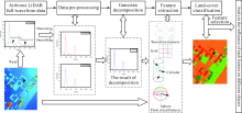
Fig.1
Experimental framework"

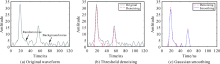
Fig.2
Waveform data pre-processing"

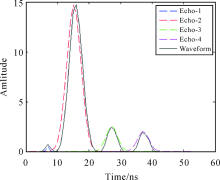
Fig.3
Results of full-waveform data Gaussian decomposition, the black solid line is the waveform data after preprocessed; the dotted line (blue, red, green, and purple) are respectively four Gaussian echo components after waveform decomposition"

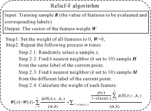
Fig.4
Implementation of Relief-F algorithm"
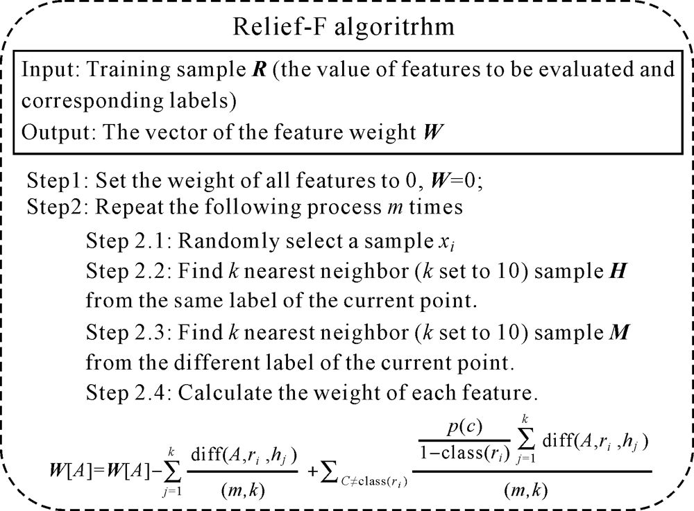
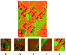
Fig.5
Experimental data and the selected training areas"
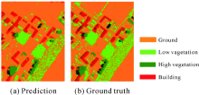
Fig.6
Classification effect of non-selective feature fusion ((a) has shown the data with semantic labels assigned by random forest classifier and (b) has shown the ground truth of experimental area)"

Tab.1
Accuracy assessment of non-selective fusion classification results based on waveform features and point cloud features"
| Predicted label | ||||||
|---|---|---|---|---|---|---|
| Ground | Low-vegetation | High-vegetation | Building | Omission/(%) | ||
| True label | Ground | 132844 | 1664 | 214 | 1745 | 2.65 |
| Low-vegetation | 2951 | 29488 | 198 | 409 | 10.77 | |
| High-vegetation | 8 | 251 | 9932 | 33 | 2.86 | |
| Building | 1017 | 338 | 83 | 11770 | 10.89 | |
| Commission/(%) | 2.91 | 7.10 | 4.75 | 15.67 | — | |
| Overall accuracy: 95.4% Kappa coefficient: 0.90 | ||||||
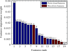
Fig.7
Feature ranking by Relief-F algorithm"

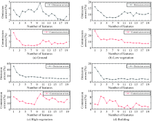
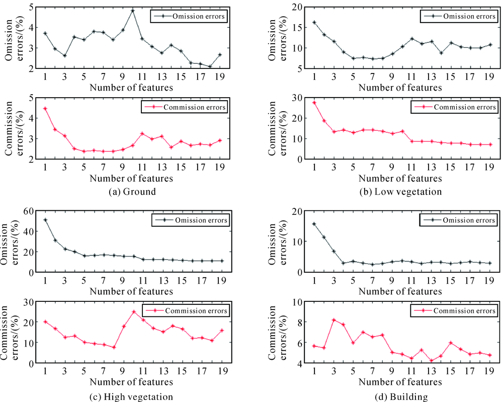
Fig.8
Error trend of the single category, black line and red line represent omission and commission errors respectively"
Tab.2
Statistics of experimental results"
| Point cloud | Waveform | Point cloud& waveform | Relief-F (first 14 features) | TerraScan | ||||||||||
|---|---|---|---|---|---|---|---|---|---|---|---|---|---|---|
| Ⅰ | Ⅱ | Ⅰ | Ⅱ | Ⅰ | Ⅱ | Ⅰ | Ⅱ | Ⅰ | Ⅱ | |||||
| Ground | 4.03 | 3.22 | 7.45 | 13.23 | 2.65 | 2.91 | 3.12 | 2.56 | 26.5 | 1.63 | ||||
| Low-vegetation | 11.8 | 8.56 | 33.5 | 30.86 | 10.7 | 7.10 | 8.73 | 7.81 | 5.59 | 55.32 | ||||
| High-vegetation | 2.59 | 4.56 | 63.6 | 32.65 | 2.86 | 4.75 | 3.23 | 4.64 | 8.21 | 16.45 | ||||
| Building | 11.7 | 23.75 | 48.1 | 31.92 | 10.9 | 15.67 | 11.9 | 17.88 | 26.5 | 1.74 | ||||
| Overall accuracy /(%) | 94.20 | 82.33 | 95.40 | 95.31 | 78.07 | |||||||||
| [1] | ELIZAROV V V, GRISHKANICH A S, KASCHEEV S V, et al. Lidar scanning module for remote environmental monitoring[C]//Proceedings of 2016 International Conference Laser Optics. St. Petersburg, Russia: IEEE, 2016. |
| [2] |
DONG Weihua, LAN Jianhang, LIANG Shunlin, et al. Selection of LiDAR geometric features with adaptive neighborhood size for urban land cover classification[J]. International Journal of Applied Earth Observation and Geoinformation, 2017,60:99-110.
doi: 10.1016/j.jag.2017.04.003 |
| [3] | SHAN Jie, TOTH C K. Topographic laser ranging and scanning: Principles and processing[M]. Boca Raton, FL: CRC Press, 2009: 3-7. |
| [4] |
LUO Shezhou, WANG Cheng, XI Xiaohuan, et al. Fusion of airborne discrete-return LiDAR and hyperspectral data for land cover classification[J]. Remote Sensing, 2016,8(1):3.
doi: 10.3390/rs8010003 |
| [5] |
SANKEY T, DONAGER J, MCVAY J, et al. UAV lidar and hyperspectral fusion for forest monitoring in the southwestern USA[J]. Remote Sensing of Environment, 2017,195:30-43.
doi: 10.1016/j.rse.2017.04.007 |
| [6] |
AWAD M M. Toward robust segmentation results based on fusion methods for very high resolution optical image and LiDAR data[J]. IEEE Journal of Selected Topics in Applied Earth Observations and Remote Sensing, 2017,10(5):2067-2076.
doi: 10.1109/JSTARS.4609443 |
| [7] |
POLIYAPRAM V, WANG Weimin, NAKAMURA R. A point-wise LiDAR and image multimodal fusion network (PMNet) for aerial point cloud 3D semantic segmentation[J]. Remote Sensing, 2019,11(24):2961.
doi: 10.3390/rs11242961 |
| [8] |
WANG Xue, LI Peijun. Extraction of urban building damage using spectral, height and corner information from VHR satellite images and airborne LiDAR data[J]. ISPRS Journal of Photogrammetry and Remote Sensing, 2020,159:322-336.
doi: 10.1016/j.isprsjprs.2019.11.028 |
| [9] |
NORMAN M, SHAFRI H Z M, MANSOR S, et al. Fusion of multispectral imagery and LiDAR data for roofing materials and roofing surface conditions assessment[J]. International Journal of Remote Sensing, 2020,41(18):7090-7111.
doi: 10.1080/01431161.2020.1754493 |
| [10] | CAO Qiong, MA Ailong, ZHONG Yanfei, et al. Urban classification by multi-feature fusion of hyperspectral image and LiDAR data[J]. Journal of Remote Sensing, 2019,23(5):892-903. |
| [11] |
WANG Minye, LIU Rufei, LU Xiushan, et al. The use of mobile lidar data and Gaofen-2 image to classify roadside trees[J]. Measurement Science and Technology, 2020,31(12):125005.
doi: 10.1088/1361-6501/aba322 |
| [12] |
NGUYEN T H, DANIEL S, GUÉRIOT D, et al. Super-resolution-based snake model-an unsupervised method for large-scale building extraction using airborne LiDAR data and optical image[J]. Remote Sensing, 2020,12(11):1702.
doi: 10.3390/rs12111702 |
| [13] | OZKAN S, AKAR G B. Hyperspectral data to relative lidar depth: An inverse problem for remote sensing[C]//Proceedings of 2019 IEEE/CVF Conference on Computer Vision and Pattern Recognition Workshops. Long Beach, CA: IEEE, 2019. |
| [14] |
BRUGGISSER M, RONCAT A, SCHAEPMAN M E, et al. Retrieval of higher order statistical moments from full-waveform LiDAR data for tree species classification[J]. Remote Sensing of Environment, 2017,196:28-41.
doi: 10.1016/j.rse.2017.04.025 |
| [15] |
ZORZI S, MASET E, FUSIELLO A, et al. Full-waveform airborne LiDAR data classification using convolutional neural networks[J]. IEEE Transactions on Geoscience and Remote Sensing, 2019,57(10):8255-8261.
doi: 10.1109/TGRS.36 |
| [16] |
MARSELIS S M, ABERNETHY K, ALONSO A, et al. Evaluating the potential of full‐waveform lidar for mapping pan-tropical tree species richness[J]. Global Ecology and Biogeography, 2020,29(10):1799-1816.
doi: 10.1111/geb.v29.10 |
| [17] |
YANG Xuebo, WANG Cheng, XI Xiaohuan, et al. Extraction of multiple building heights using ICESat/GLAS full-waveform data assisted by optical imagery[J]. IEEE Geoscience and Remote Sensing Letters, 2019,16(12):1914-1918.
doi: 10.1109/LGRS.2019.2911967 |
| [18] |
LAI Xudong, YUAN Yifei, LI Yongxu, et al. Full-waveform LiDAR point clouds classification based on wavelet support vector machine and ensemble learning[J]. Sensors, 2019,19(14):3191.
doi: 10.3390/s19143191 |
| [19] |
SHINOHARA T, XIU Haoyi, MATSUOKA M. FWNet: Semantic segmentation for full-waveform LiDAR data using deep learning[J]. Sensors, 2020,20(12):3568.
doi: 10.3390/s20123568 |
| [20] | MALLET C, SOERGEL U, BRETAR F. Analysis of full-waveform lidar data for classification of urban areas[J]. Photogrammetrie Fernerkundung Geoinformation, 2008,5(5):337-349. |
| [21] |
MALLET C, BRETAR F. Full-waveform topographic lidar: State-of-the-art[J]. ISPRS Journal of Photogrammetry and Remote Sensing, 2009,64(1):1-16.
doi: 10.1016/j.isprsjprs.2008.09.007 |
| [22] | RONCAT A, WAGNER W, MELZER T, et al. Echo detection and localization in full-waveform airborne laser scanner data using the averaged square difference function estimator[J]. The Photogrammetric Journal of Finland, 2008,21(1):62-75. |
| [23] |
WAGNER W, ULLRICH A, DUCIC V, et al. Gaussian decomposition and calibration of a novel small-footprint full-waveform digitising airborne laser scanner[J]. ISPRS Journal of Photogrammetry and Remote Sensing, 2006,60(2):100-112.
doi: 10.1016/j.isprsjprs.2005.12.001 |
| [24] |
JUTZI B, STILLA U. Range determination with waveform recording laser systems using a Wiener Filter[J]. ISPRS Journal of Photogrammetry and Remote Sensing, 2006,61(2):95-107.
doi: 10.1016/j.isprsjprs.2006.09.001 |
| [25] |
WU Jiaying, VAN AARDT J A N, ASNER G P. A comparison of signal deconvolution algorithms based on small-footprint LiDAR waveform simulation[J]. IEEE Transactions on Geoscience and Remote Sensing, 2011,49(6):2402-2414.
doi: 10.1109/TGRS.2010.2103080 |
| [26] | KOMA Z, KOENIG K, HÖFLE B. Urban tree classification using full-waveform airborne laser scanning[C]//Proceedings of the ISPRS Annals of the Photogrammetry, Remote Sensing and Spatial Information Sciences. Prague, Czech Republic: ISPRS, 2016: 185-192. |
| [27] |
MA Hongchao, ZHOU Weiwei, ZHANG Liang. DEM refinement by low vegetation removal based on the combination of full waveform data and progressive TIN densification[J]. ISPRS Journal of Photogrammetry and Remote Sensing, 2018,146:260-271.
doi: 10.1016/j.isprsjprs.2018.09.009 |
| [28] |
ALEXANDER C, TANSEY K, KADUK J, et al. Backscatter coefficient as an attribute for the classification of full-waveform airborne laser scanning data in urban areas[J]. ISPRS Journal of Photogrammetry and Remote Sensing, 2010,65(5):423-432.
doi: 10.1016/j.isprsjprs.2010.05.002 |
| [29] | WEINMANN M, JUTZI B, MALLET C. Semantic 3D scene interpretation: A framework combining optimal neighborhood size selection with relevant features[C]//Proceedings of the ISPRS Annals of the Photogrammetry, Remote Sensing and Spatial Information Sciences. Zurich, Switzerland: ISPRS, 2014: 181-188. |
| [30] |
GUO Bo, HUANG Xianfeng, ZHANG Fan, et al. Classification of airborne laser scanning data using JointBoost[J]. ISPRS Journal of Photogrammetry and Remote Sensing, 2015,100:71-83.
doi: 10.1016/j.isprsjprs.2014.04.015 |
| [31] |
DONG Weihua, LAN Jianhang, LIANG Shunlin, et al. Selection of LiDAR geometric features with adaptive neighborhood size for urban land cover classification[J]. International Journal of Applied Earth Observation and Geoinformation, 2017,60:99-110.
doi: 10.1016/j.jag.2017.04.003 |
| [32] |
GRESSIN A, MALLET C, DEMANTKÉ J, et al. Towards 3D lidar point cloud registration improvement using optimal neighborhood knowledge[J]. ISPRS Journal of Photogrammetry and Remote Sensing, 2013,79:240-251.
doi: 10.1016/j.isprsjprs.2013.02.019 |
| [33] |
BREIMAN L. Random forests[J]. Machine Learning, 2001,45(1):5-32.
doi: 10.1023/A:1010933404324 |
| [34] |
MALLET C, BRETAR F, ROUX M, et al. Relevance assessment of full-waveform lidar data for urban area classification[J]. ISPRS Journal of Photogrammetry and Remote Sensing, 2011,66(S6):S71-S84.
doi: 10.1016/j.isprsjprs.2011.09.008 |
| [35] | CAI Zhan, MA Hongchao, ZHANG Liang. Feature selection for airborne LiDAR data filtering: A mutual information method with Parzon window optimization[J]. GIScience & Remote Sensing, 2020,57(3):323-337. |
| [36] | LI Xiaolan. The study and application of feature selection algorithms based on relief[D]. Dalian: Dalian University of Technology, 2013. |
| [37] | KONONENKO I. Estimating attributes: Analysis and extensions of RELIEF[C]//Proceedings of the European Conference on Machine Learning. Italy: Springer, 1994. |
| [38] | KIRA K, RENDELL L A. A practical approach to feature selection[C]//Proceedings of the Ninth International Workshop on Machine Learning. Aberdeen, Scotland: Morgan Kaufmann Publishers Inc., 1992. |
| [39] | MA Hongchao, CAI Zhan, ZHANG Liang. Comparison of the filtering models for airborne LiDAR data by three classifiers with exploration on model transfer[J]. Journal of Applied Remote Sensing, 2018,12(1):016021. |
| [1] | Juntao YANG,Zhizhong KANG,Zhou YANG. A Robust Model Fitting-based Method for Transmission Line Extraction from Airborne LiDAR Point Cloud Data [J]. Journal of Geodesy and Geoinformation Science, 2021, 4(3): 60-71. |
| Viewed | ||||||
|
Full text |
|
|||||
|
Abstract |
|
|||||