
Journal of Geodesy and Geoinformation Science ›› 2018, Vol. 1 ›› Issue (1): 61-78.doi: 10.11947/j.JGGS.2018.0108
Lei YAN1,Ruihua ZHANG1,Yanbiao SUN2
Received:2018-01-07
Accepted:2018-04-07
Online:2018-12-20
Published:2019-11-20
About author:Lei YAN(1956—),male,PhD,professor, majors in technology of high resolution imaging and remote sensing calibration. E-mail:lyan@pku.edu.cn
Supported by:Lei YAN,Ruihua ZHANG,Yanbiao SUN. A Preliminary Study on the Theory of Polar Coordinates Digital Photogrammetry and the Coordinate System of Spatial Information[J]. Journal of Geodesy and Geoinformation Science, 2018, 1(1): 61-78.
Add to citation manager EndNote|Reference Manager|ProCite|BibTeX|RefWorks
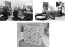
Fig.1
Spatial instrument system used to test different parallax angle polar coordinates.Left to right:variable angle calibration;double angle push;and high-overlap 4×4 detection array"


Fig.2
Geometric basis for 2D imaging"
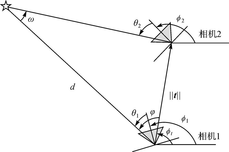
Fig.3
Parameterization of 3D feature points in polar coordinate parameter space"

Fig.4
The effect of parallax angle on the XYZ expression"
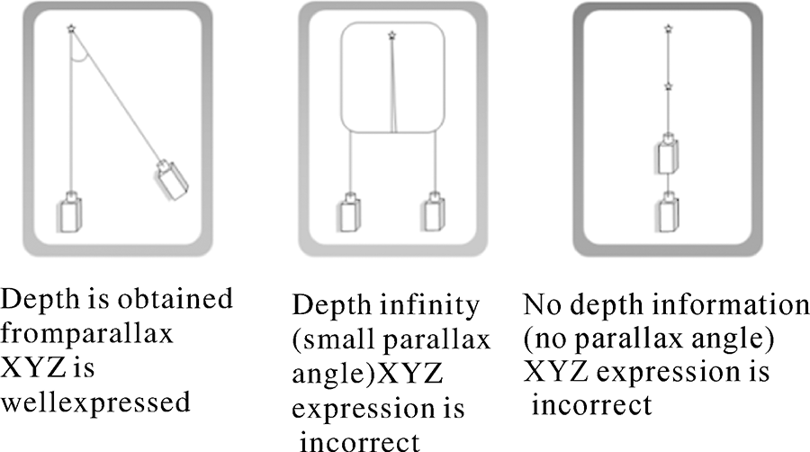

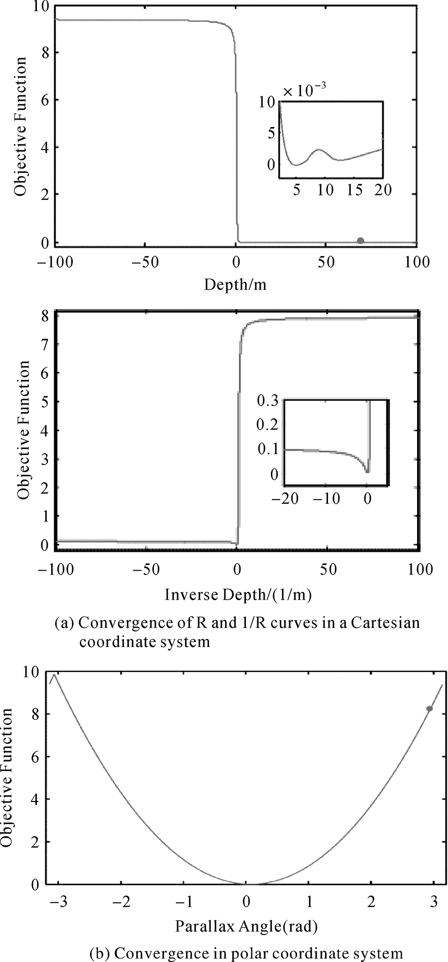
Fig.5
Performance Comparisonbetween Cartesian and Polar coordinate systems"


Fig.6
Convergence graph under different coordinate systems"
Tab.1
The convergence of G2O,sSBA,and ParallaxBA for Vaihingen data sets"
| Vaihingen | G20 GN Cartesian coordinates | G20 LM Cartesian coordinates | sSBA Cartesian coordinates | ParallaxBA GN Polar coordinates | ParallaxBA LM Polar coordinates | |
|---|---|---|---|---|---|---|
| Initial MSE | 144707.21 | 144707.21 | 144707.21 | 144707.18 | 144710.18 | |
| Convergence MSE | N/A | 135.060663 | 0.126012 | 0.126012 | 0.126012 | |
| Number of iterations | N/A | 200 | 8 | 6 | 20 | |
| Linear equation | N/A | 214 | 8 | 6 | 25 | |
| Single iteration time | Win | N/A | N/A | N/A | 1.21 | 1.21 |
| Linux | N/A | 1.2 | 0.8 | 1.45 | 1.45 | |
| total time | Win | N/A | N/A | N/A | 8.46 | 26.43 |
| Linux | N/A | 263.6 | 6.8 | 8.86 | 35.24 | |
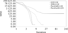
Fig.7
Changes in the objective function curves for the Vaihingen data by the G2O,sSBA,and ParallaxBA models"

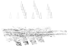
Fig.8
Reconstruction of the Vaihingen terrain and camera positions"


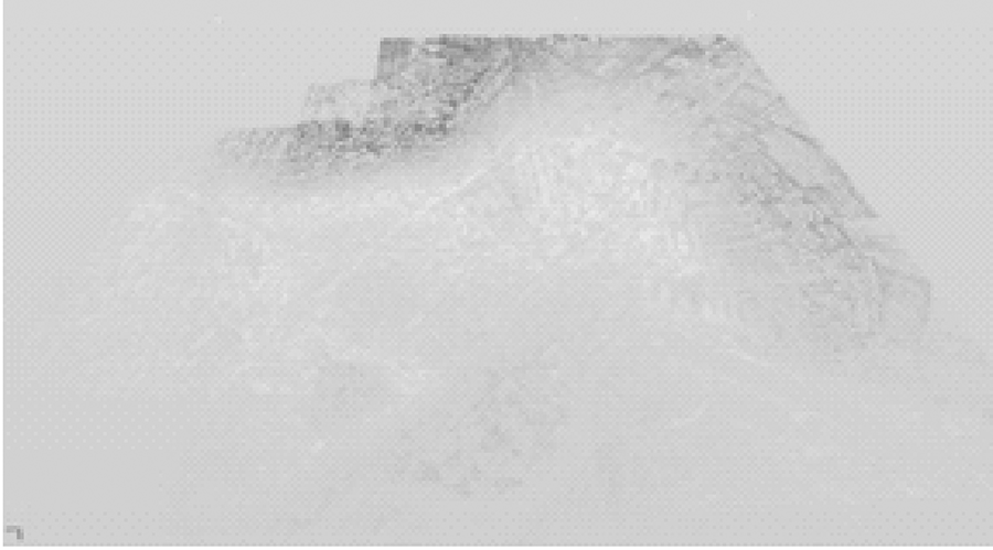
Fig.9
Reconstruction of the Vaihingen terrain"
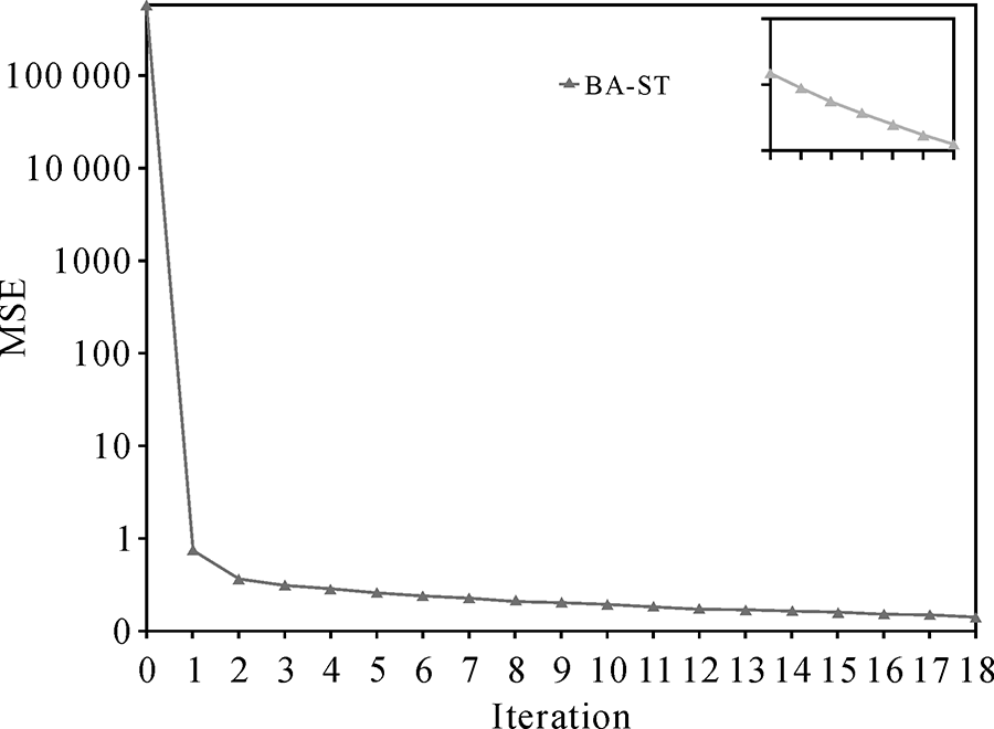
Tab.2
The convergence of G2O,sSBA,and ParallaxBA for College data sets"
| College | G20 GN Cartesian coordinates | G20 LM Cartesian coordinates | sSBA Cartesian coordinates | ParallaxBA GN Polar coordinates | ParallaxBA LM Polar coordinates | |
|---|---|---|---|---|---|---|
| Initial MSE | 202329.64 | 202329.64 | 202329.64 | 202329.44 | 202329.44 | |
| Convergence MSE | N/A | 25.723307 | 9.272481 | 0.734738 | 0.734738 | |
| Number of iterations | N/A | 200 | 200 | 12 | 17 | |
| Linear equation | N/A | 349 | 228 | 12 | 17 | |
| Single iteration time | Win | N/A | N/A | N/A | 2.71 | 2.71 |
| Linux | N/A | 2.51 | 2.72 | 3.85 | 3.85 | |
| total time | Win | N/A | N/A | N/A | 37.14 | 49.68 |
| Linux | N/A | 674.83 | 453.22 | 51.55 | 69.58 | |

Fig.10
Changes in the objective function curves for the College data by the G2O,sSBA,and ParallaxBA models"
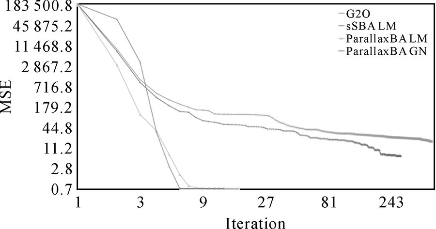

Fig.11
Reconstruction of the College terrain and camera positions"


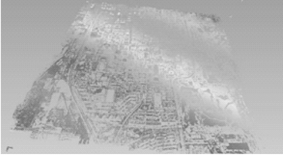
Fig.12
Reconstruction of the College terrain"
Tab.3
The convergence of G2O, sSBA, and ParallaxBA for Village data sets"
| Village | G20 GN Cartesian coordinates | G20 LM Cartesian coordinates | sSBA Cartesian coordinates | ParallaxBA GN Polar coordinates | ParallaxBA LM Polar coordinates | |
|---|---|---|---|---|---|---|
| With or without ground control points | Yes | Yes | Yes | No | No | |
| Initial MSE | 28174.10 | 28174.10 | 28968.73 | 28170.98 | 28170.98 | |
| Convergence MSE | N/A | 0.083716 | 0.083716 | 0.083716 | 0.083716 | |
| Number of iterations | N/A | 34 | 8 | 6 | 11 | |
| Linear equation | N/A | 55 | 8 | 6 | 11 | |
| Single iteration time | Win | N/A | N/A | N/A | 0.67 | 0.67 |
| Linux | N/A | 0.62 | 0.56 | 0.96 | 0.96 | |
| total time | Win | N/A | N/A | N/A | 5.07 | 7.92 |
| Linux | N/A | 27.46 | 4.54 | 6.98 | 12.23 | |

Fig.13
Changes in the objective function curves for the Village data by the G2O,sSBA,and ParallaxBA models"


Fig.14
Reconstruction of the Village terrain and camera positions"
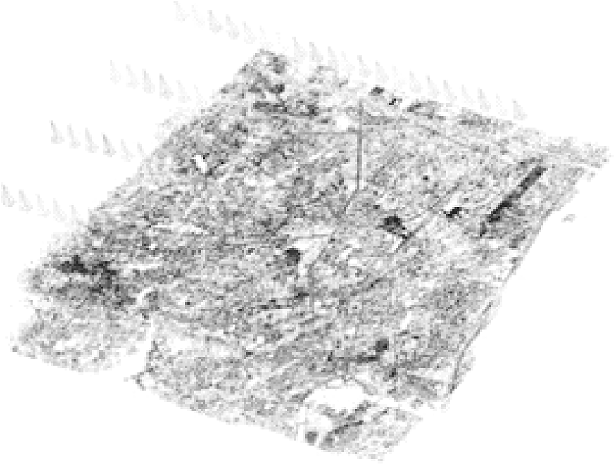

Fig.15
Reconstruction of the Village terrain"
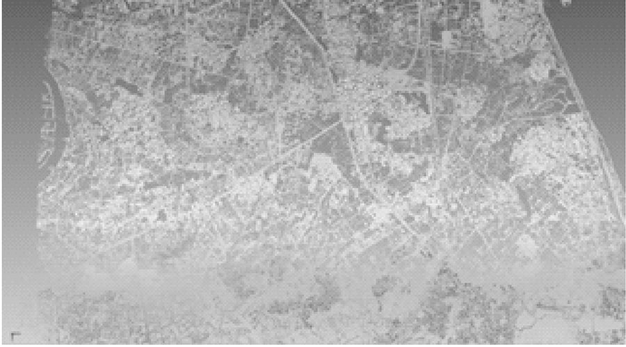

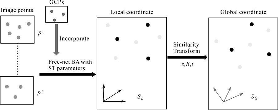
Fig.16
The steps of similarity transformation"
Tab.4
Real aero data set parameters"
| Village data | Taian data | |
|---|---|---|
| Number of images | 90 | 737 |
| Number of belts | 4 | 12 |
| terrain | hills | mountain |
| scale | 1∶1000 | 1∶5000 |
| Area size | 2km*3.5km | 53km*35km |
| camera | DMC | DMC |
| Image frame | 7680*13824 | 7680*13824 |
| Resolution (m) | 0.1 | 0.5 |
| Control point | 6 | 32 |
| checking point | 6 | 20 |

Fig.17
Distribution of cameras,control points,and checkpoints for the Village data"
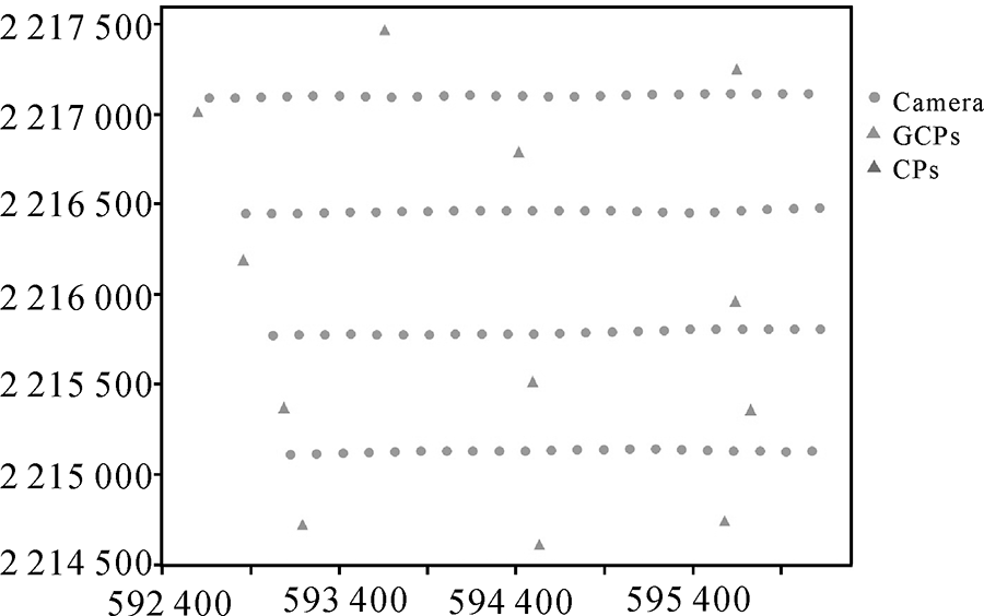

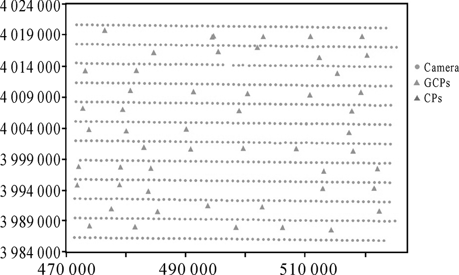
Fig.18
Distribution of cameras,control points,and checkpoints for the Taian data"
Tab.5
Adjustment parameters and operating efficiency"
| Village | Taian | |
|---|---|---|
| Encryption points | 305719 | 2743625 |
| Image points | 779320 | 6017028 |
| Initial error | 56432.16 | 590764.93 |
| Convergence error | 0.09013 | 0.138706 |
| Number of iterations | 11 | 18 |
| total time(second) | 11.2 | 126.4 |

Fig.19
Objective function convergence process for the Village dataset"
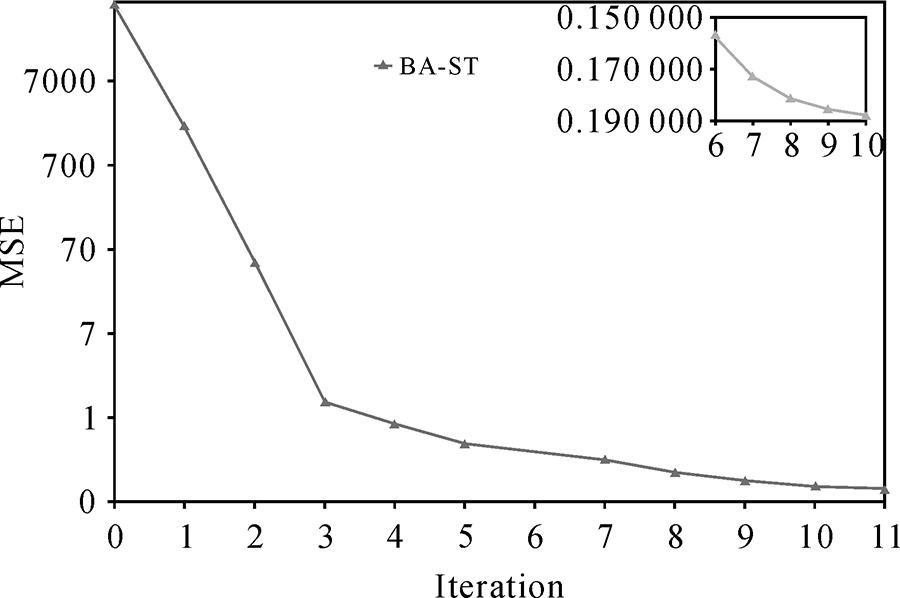

Fig.20
Objective function convergence process for the Taian dataset"
Tab.6
Experimental results of Village and Taian datasets"
| Parameters | Village | Taian | |
|---|---|---|---|
| Maximum error (meter) | East | 0.1178 | 0.6387 |
| North | 0.2586 | 1.2728 | |
| Flat | 0.2352 | 1.0425 | |
| Elevation | 0.3161 | 3.5087 | |
| RMSE | East | 0.0690 | 0.3073 |
| North | 0.1502 | 0.4802 | |
| Flat | 0.1653 | 0.5702 | |
| Elevation | 0.2194 | 1.8348 | |

Fig.21
Reconstruction of encrypted points by the polar coordinate absolute network adjustment model for two datasets"


Fig.22
Close range photogrammetry"
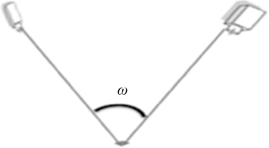

Fig.23
Aerial array imaging"
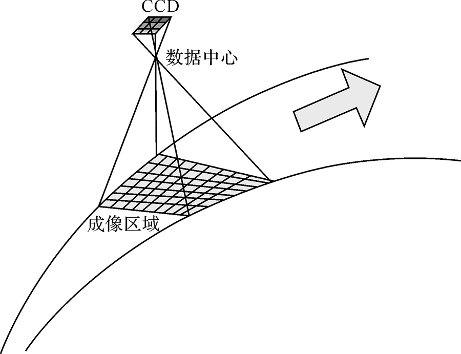

Fig.24
Relationship between charge-coupled device pixels and the imaging region"
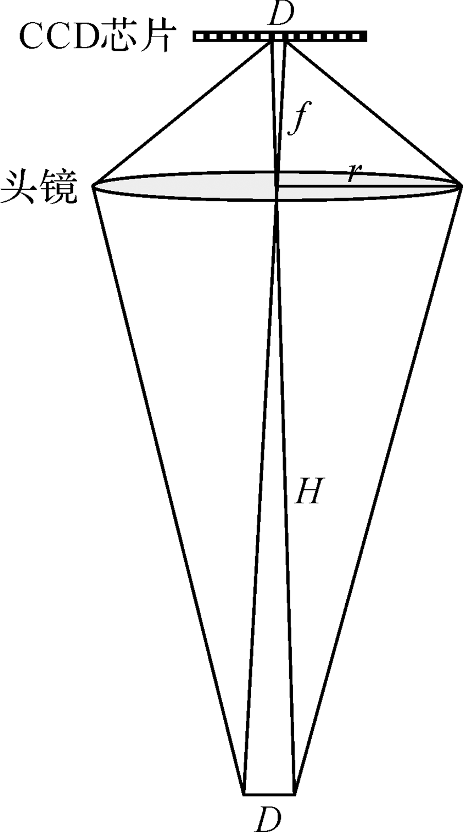
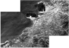
Fig.25
Accurate mosaic of ocean remote sensing images"

Tab.7
The comparison table between the original method and the introduction of polar coordinate method"
| Comparison element | Marine maritime | ||
|---|---|---|---|
| Quantitative characteristics | Data validity | Target Recognition | |
| Original method | weak | common | weak |
| Polar coordinate method | Unmanned boat monitoring calibration | Polar coordinates change angle, good | High recognition |
Tab.8
Comparison of the characteristics of Cartesian and polar coordinates"
| Comparison element | Normal image (rectangular coordinate) | High overlap image | Image accuracy- efficiency-anti- interference | large angle | Changing posture | Aviation array Space array | Compared with the national military standard data organization storage |
|---|---|---|---|---|---|---|---|
| Original method | Processable | Easy singularity, sometimes divergent | Common | difficult | difficult | Different coordinates | Right angle- radius conversion |
| Polar coordinate method | Processable | Greatly avoid singularity, no divergence | Increase in magnitude | Convenient | Convenient | Unified coordinates | No conversion required |
| [1] |
WANG Zhizhuo . The Principle of Photogrammetry[J]. Bulletin of Surveying and Mapping, 1979,4:50.
doi: 10.1016/j.brachy.2019.05.006 pmid: 31230942 |
| [2] | LUO He . A General Analytical Method of Aerial Triangulation[J]. Acta Geodaetica et Cartographica Sinica, 1958,1:3-22. |
| [3] | ZHOU Ka . Spatial Aerotriangulation[J]. China Civil Engineering Journal, 1956,3:59-78. |
| [4] |
ZHAO L, HUANG S, SUN Y, YAN L . ParallaxBA:Bundle Adjustment Using Parallax Angle Feature Parametrization[J]. International Journal of Robotics Research, 2015,34(4-5):493-516.
doi: 10.1177/0278364914551583 |
| [5] | ZHAO L, HUANG S, YAN L , et al. Parallax Angle Parametrization for Monocular SLAM [C].IEEE International Conference on Robotics and Automation,IEEE, 2011, 3117-3124. |
| [6] |
SUN Y, SUN H, YAN L , et al. RBA:Reduced Bundle Adjustment for Oblique Aerial Photogrammetry[J]. ISPRS Journal of Photogrammetry and Remote Sensing, 2016,121:128-142.
doi: 10.1016/j.isprsjprs.2016.09.005 |
| [7] | ZHAO L, HUANG S, YAN L , et al. Large-scale Monocular SLAM by Local Bundle Adjustment and Map Joining [C].International Conference on Control Automation Robotics and Vision.IEEE, 2011, 431-436. |
| [8] | SUN Yanbiao . Study on Convergence and Convergence Speed of Polar Coordinate Beam Method Adjustment Model[D]. Doctoral Dissertation of Peking University, 2015. |
| [9] |
CIVERA J, DAVISON A J, MONTIEL J M M . Inverse Depth Parametrization for Monocular SLAM[J]. IEEE Transactions on Robotics, 2008,24(5):932-945.
doi: 10.1109/TRO.2008.2003276 |
| [10] | SOLA J . Consistency of the Monocular EKF-SLAM Algorithm for Three Different Landmark Parametrizations [C].IEEE International Conference on Robotics and Automation.IEEE, 2010, 3513-3518. |
| [11] | MONTIEL J M M, CIVERA J, DAVISON A J . Unified Inverse Depth Parameterization for Monocular SLAM [C].Robotics Science and Systems, 2006. |
| [12] | CIVERA J, DAVISON A J, MONTIEL J M M . Inverse Depth to Depth Conversion for Monocular SLAM [C].IEEE International Conference on Robotics and Automation.IEEE, 2007, 2778-2783. |
| [13] | CHENG Chengqi, GUAN Li . Global Dissection Model and Address Coding Based on Map Extension[J]. Acta Geodaetica et Cartographica Sinica, 2010,39(3):295-302. |
| [14] | CHENG Chengqi et al. The Spatial Information Division Organization Introduction[M]. Beijing: Science Press, 2012. |
| [15] | CHENG Chengqi, SONG Shuhua, P U Guoliang , et al. A Preliminary Study on the Global Unique GeoID Model of Spatial Information[J]. Science of Surveying and Mapping, 2010,35(6):73-75,264. |
| [16] | ZHAO Liang , MonoSLAM:Parameterization,Bundle Adjustment and Sub Graph Merging Model Theory[M]. Doctoral Dissertation of Peking University, 2012. |
| [17] | BROWN D C . The Bundle Adjustment:Progress and Prospects[J]. International Archives of Photogrammetry Papers, 1976,21:29-33. |
| [18] | SLAMA C C . Manual of Photogrammetry,Fourth Edition[M]. ASPRS, 1980. |
| [19] |
COOPER M A R, CROSS P A . Statistical Concepts and Their Application in Photogrammetry and Surveying[J]. Photogrammetric Record, 1991,13(77):645-678.
doi: 10.1111/j.1477-9730.1991.tb00728.x |
| [20] |
YAN L, CHEN R, SUN H , et al. A Novel Bundle Adjustment Method with Additional Ground Control Point Constraint[J]. Remote Sensing Letters, 2017,8(1):68-77.
doi: 10.1080/2150704X.2016.1235809 |
| [21] |
SUN Y, ZHAO L, HUANG S, YAN L . L-MATH Container Loading Mathjax-SIFT:SIFT Feature Extraction and Matching for Large Images in Large-scale Aerial Photogrammetry[J]. ISPRS Journal of Photogrammetry and Remote Sensing, 2014,91:1-16.
doi: 10.1016/j.isprsjprs.2014.02.001 |
| [22] |
SUN Y, ZHAO L, HUANG S, YAN L . Line Matching Based on Planar Homography for Stereo Aerial Images[J]. ISPRS Journal of Photogrammetry and Remote Sensing, 2015,104:1-17.
doi: 10.1016/j.isprsjprs.2014.12.003 |
| [23] | SUN Y, LIU X, CHEN R, WAN J, WANG Q , et al. Application and Performance Analysis of a New Bundle Adjustment Model[J]. ISPRS Annals of Photogrammetry Remote Sensing and Spatial Information Sciences, 2017, IV- 2/W4:273-278. |
| [24] | TONG Xiaohua, YE Zhen, LIU Shijie . Key Technology and Application of High Resolution Satellite Flutter Detection Compensation[J]. Acta Geodaetica et Cartographica Sinica, 2017,46(10):1500-1508. |
| [25] | LI Ying, ZHU Xueyuan, CAO Yan , et al. The Review of Marine Remote Sensing Monitoring Technology[J]. Marine Science Bulletin, 2015,34(2):121-129. |
| [1] | Zhilin LI,Peichao GAO,Zhu XU. Information Theory of Cartography: An Information-theoretic Framework for Cartographic Communication [J]. Journal of Geodesy and Geoinformation Science, 2021, 4(1): 1-16. |
| [2] | Mi WANG,Zhiqi ZHANG,Zhipeng DONG,Shuying JIN,Hongbo SU. Stream-computing of High Accuracy On-board Real-time Cloud Detection for High Resolution Optical Satellite Imagery [J]. Journal of Geodesy and Geoinformation Science, 2019, 2(2): 50-59. |
| Viewed | ||||||
|
Full text |
|
|||||
|
Abstract |
|
|||||