
Journal of Geodesy and Geoinformation Science ›› 2021, Vol. 4 ›› Issue (3): 13-24.doi: 10.11947/j.JGGS.2021.0302
• Special Issue • Previous Articles Next Articles
Petar DONEV1( ),Hong WANG1(),Shuhong QIN2,Pengyu MENG1,Jinbo LU1
Received:2020-09-15
Accepted:2021-01-15
Online:2021-09-20
Published:2021-10-09
Contact:
Hong WANG
E-mail:petardonev@hhu.edu.cn;hongwang@hhu.edu.cn
About author:Petar DONEV E-mail: Petar DONEV,Hong WANG,Shuhong QIN,Pengyu MENG,Jinbo LU. Estimating the Forest Above-ground Biomass Based on Extracted LiDAR Metrics and Predicted Diameter at Breast Height[J]. Journal of Geodesy and Geoinformation Science, 2021, 4(3): 13-24.
Add to citation manager EndNote|Reference Manager|ProCite|BibTeX|RefWorks
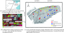
Fig.1
Study area"

Tab.1
Summary of the field measured data in June and October 2019"
| Data collected | Tree number | Height range/m | Mean height/m | DBH range/cm | Mean DBH/cm |
|---|---|---|---|---|---|
| June | 540 | 4.2—16.3 | 10.41 | 6.05—38.73 | 18.38 |
| October | 144 | 6.4—15.6 | 10.37 | 37.3—96.0 | 55.87 |
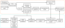
Fig.2
Standard study flowchart of the forest AGB prediction"

Tab.2
Summary of extracted LiDAR metrics from the UAV LiDAR data"
| Metrics | Description |
|---|---|
| Elev kurtosis | Kurtosis of the heights of all points above 2m |
| Elev AAD | The absolute average deviation of the heights of all points above 2m |
| Elev MAD median | Median absolute deviation of the median height |
| Elev percentile # | Height Percentile (01, 05, 10, 20, 25, 30, 40, 50, 60, 70, 75, 80, 90, 95, 99) |
| Elev maximum | Maximum height of all points above 2m |
| Elev mean | Mean height of all points above 2m |
| Elev stddev | The standard deviation of the heights of all points above 2m |
| Elev variance | A variance of the heights of all points above 2m |
| Elev CV | Coefficient of variation of the heights of all points above 2m |
| Elev IQ | An interquartile distance of the height of all points above 2m |
| Elev skewness | The skewness of the heights of all points above 2m |
| Elev L # | L-moments of height (L1, L2, L3, L4) |
| Elev MAD mode | Mode deviation of the median height |
| Elev L CV | L-moment Coefficient of Variation of height |
| Elev L skewness | L-moment Skewness of the height |
| Elev L kurtosis | L-moment Kurtosis of the height |
| Elev SQRT mean SQ | Height quadratic mean |
| Elev CURT means CUBE | Height cubic mean |
| LP | Percentage of last returns above ground |
| Canopy cover above 2m | Percentage first returns above 2.00 |
| Canopy relief ratio | The proportion of the Canopy and the relief |
Tab.3
Field-estimated AGB in the eight plots, based on the allometric equation for Robinia Pseudoacacia forest"
| Plot ID | 1 | 2 | 3 | 4 | 5 | 6 | 7 | 8 |
|---|---|---|---|---|---|---|---|---|
| Number of trees | 43 | 70 | 47 | 98 | 91 | 87 | 46 | 47 |
| H mean/m | 7.38 | 11.74 | 12.64 | 11.22 | 8.42 | 10.90 | 10.21 | 13.42 |
| SD | 1.13 | 3.29 | 1.66 | 2.25 | 1.47 | 1.75 | 1.49 | 2.22 |
| DBH mean/cm | 14.19 | 17.65 | 18.40 | 17.87 | 12.55 | 13.18 | 15.88 | 17.29 |
| SD | 3.85 | 4.80 | 5.03 | 7.68 | 5.39 | 4.21 | 5.51 | 6.67 |
| AGB mean/(mg/hm2) | 19.64 | 68.84 | 50.57 | 92.63 | 39.85 | 49.18 | 33.42 | 50.70 |
| SD | 7.49 | 23.18 | 20.47 | 43.55 | 14.26 | 18.24 | 11.71 | 25.03 |

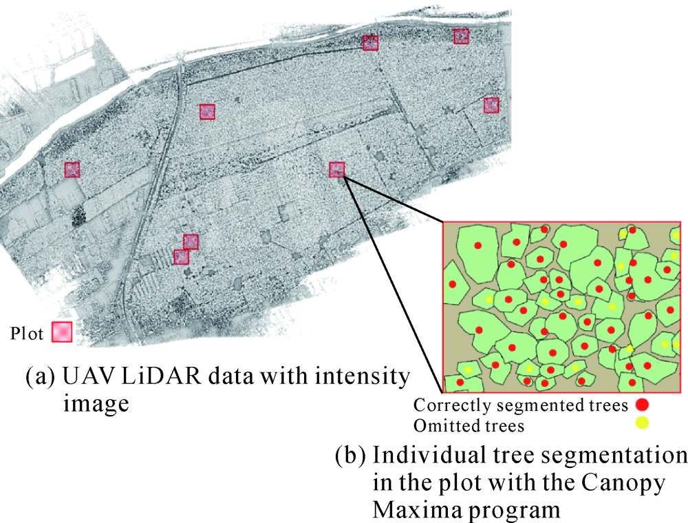
Fig.3
The ITS results (The extracted polygons represent individual tree crowns from the correctly segmented and omitted tress by the program)"
Tab.4
Accuracy results of the UAV LiDAR ITS method compared with field data in the eight plots"
| Plot ID | Trees per plot | Segmented trees | Omitted trees | r | p | F | Accuracy/(%) |
|---|---|---|---|---|---|---|---|
| 1 | 59 | 45 | 14 | 0.76 | 1 | 0.87 | 76 |
| 2 | 80 | 71 | 9 | 0.89 | 1 | 0.94 | 89 |
| 3 | 59 | 47 | 12 | 0.80 | 1 | 0.89 | 80 |
| 4 | 125 | 104 | 21 | 0.83 | 1 | 0.91 | 83 |
| 5 | 114 | 98 | 16 | 0.86 | 1 | 0.92 | 86 |
| 6 | 105 | 87 | 18 | 0.83 | 1 | 0.91 | 83 |
| 7 | 52 | 46 | 6 | 0.88 | 1 | 0.94 | 88 |
| 8 | 63 | 47 | 16 | 0.75 | 1 | 0.85 | 75 |
| Total | 657 | 545 | 112 | 0.83 | 1 | 0.91 | 83 |
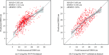
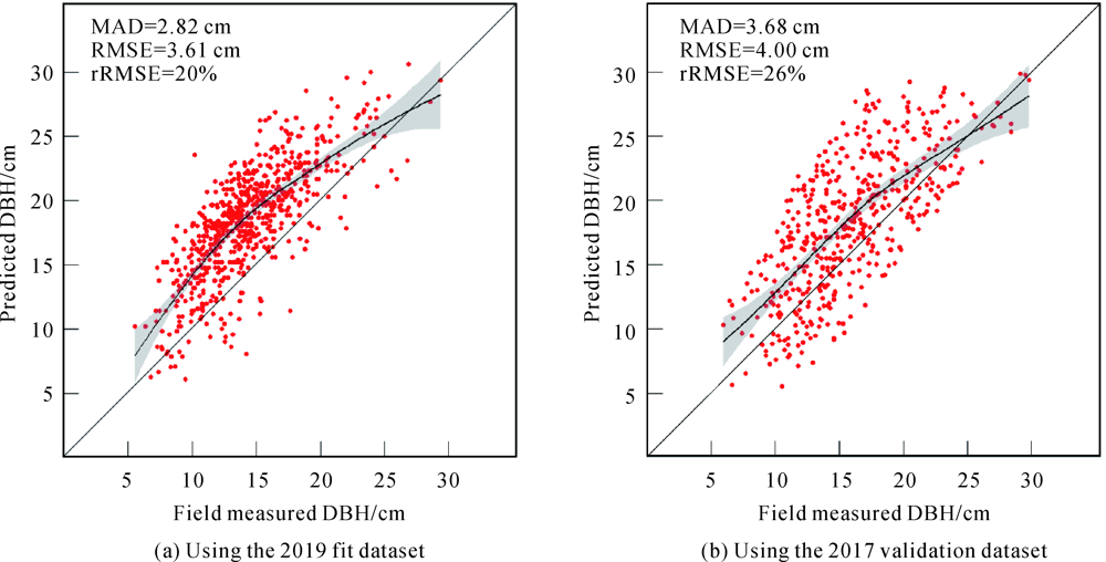
Fig.4
Compared field measured DBH and DBH predicted with the nonlinear estimation model"
Tab.5
Estimation accuracy statistics for the AGB prediction methods using the UAV LiDAR point cloud data derived metrics"
| Method | R2 | RMSE/(mg/hm2) | rRMSE/(%) |
|---|---|---|---|
| MLR | 0.70 | 17.73 | 37 |
| RF | 0.72 | 13.30 | 31 |
| SVR | 0.82 | 12.97 | 28 |
Fig.5
Field estimated AGB vs. predicted AGB values"
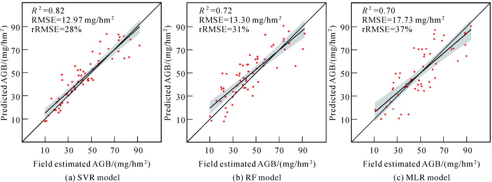
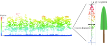
Fig.6
UAV LiDAR data tree height image, and ITS with the tree measurement tool from the LiDAR data viewer (LDV), from which we obtain tree height and crown information"

Tab.6
Evaluation statistics for the DBH prediction model"
| Dataset | Number of trees | MAD /cm | RMSE /cm | rRMSE /(%) | Error<10% /(%) |
|---|---|---|---|---|---|
| 2019 fit dataset | 684 | 2.82 | 3.61 | 20 | 92 |
| 2017 validation dataset | 488 | 3.68 | 4.00 | 26 | 72 |
Tab.7
Estimation error of the AGB prediction in the eight plots with the MLR, RF and the SVR method"
| Plot ID | 1 | 2 | 3 | 4 | 5 | 6 | 7 | 8 | Error≤20% /(%) |
|---|---|---|---|---|---|---|---|---|---|
| Number of trees | 43 | 70 | 47 | 98 | 91 | 87 | 46 | 47 | |
| MLR-AGB/(mg/hm2) mean | 17.44 | 85.71 | 61.62 | 94.58 | 47.71 | 68.91 | 38.81 | 69.63 | 53 |
| SD | 13.87 | 19.13 | 23.58 | 31.11 | 22.82 | 17.22 | 24.22 | 24.55 | |
| RF-AGB/(mg/hm2) mean | 18.09 | 81.96 | 60.98 | 90.58 | 47.08 | 68.16 | 39.59 | 63.30 | 60 |
| SD | 10.55 | 19.99 | 21.48 | 26.91 | 14.52 | 17.09 | 13.25 | 16.10 | |
| SVR-AGB/(mg/hm2) mean | 17.93 | 80.48 | 61.39 | 75.28 | 47.35 | 68.75 | 39.05 | 59.09 | 62 |
| SD | 7.04 | 21.81 | 21.09 | 19.93 | 13.34 | 17.82 | 11.93 | 13.48 |
| [1] |
URBAZAEV M, THIEL C, CREMER F, et al. Estimation of forest aboveground biomass and uncertainties by integration of field measurements, airborne LiDAR, and SAR and optical satellite data in Mexico[J]. Carbon Balance and Management, 2018,13(1):1-20.
doi: 10.1186/s13021-017-0089-6 |
| [2] |
CHEN Lin, REN Chunying, ZHANG Bai, et al. Estimation of forest above-ground biomass by geographically weighted regression and machine learning with sentinel imagery[J]. Forests, 2018,9(10):582-602.
doi: 10.3390/f9100582 |
| [3] | VASHUM K T, JAYAKUMAR S. Methods to estimate above-ground biomass and carbon stock in natural forests - a review[J]. Journal of Ecosystem & Ecography, 2012,2(4):1-7. |
| [4] | SMITH M L, ANDERSON J, FLADELAND M. Forest canopy structural properties[M]//HOOVER C M. Field Measurements for Forest Carbon Monitoring: A Landscape-Scale Approach. Dordrecht: Springer, 2008. |
| [5] | CONDIT R. Methods for estimating aboveground biomass of forest and replacement vegetation in the tropics[J]. Center for Tropical Forest Science Research Manual, 2008,73:1-73. |
| [6] | UYKUN C. Above-ground biomass and carbon estimations and recommendations for forests in turkey[D]. Michigan: Michigan Technological University, 2018. |
| [7] |
LARJAVAARA M, MULLER-LANDAU H C. Measuring tree height: a quantitative comparison of two common field methods in a moist tropical forest[J]. Methods in Ecology and Evolution, 2013,4(9):793-801.
doi: 10.1111/2041-210X.12071 |
| [8] | LATIFI H. Characterizing forest structure by means of remote sensing: a review[M]//ESCALANTE B. Remote Sensing - Advanced Techniques and Platforms. Shanghai: InTech, 2012: 13. |
| [9] | DUBE T. Optical remote sensing of aboveground forest biomass and carbon stocks in resource-constrained african environments[D]. Pietermaritzburg: University of Kwa Zulu-Natal, 2015. |
| [10] |
DONG Lixin, TANG Shihao, MIN Min, et al. Aboveground forest biomass based on OLSR and an ANN model integrating LiDAR and optical data in a mountainous region of China[J]. International Journal of Remote Sensing, 2019,40(15):6059-6083.
doi: 10.1080/01431161.2019.1587201 |
| [11] |
LI Yingchang, LI Mingyang, LI Chao, et al. Forest aboveground biomass estimation using Landsat 8 and Sentinel-1A data with machine learning algorithms[J]. Scientific Reports, 2020,10(1):1-12.
doi: 10.1038/s41598-019-56847-4 |
| [12] | LU Dengsheng, CHEN Qi, WANG Guangxing, et al. Aboveground forest biomass estimation with landsat and LiDAR data and uncertainty analysis of the estimates[J]. International Journal of Forestry Research, 2012,2012(4):436537. |
| [13] |
MASCARO J, ASNER G P, DAVIES S, et al. These are the days of lasers in the jungle[J]. Carbon Balance and Management, 2014,9(1):1-3.
doi: 10.1186/1750-0680-9-1 |
| [14] | LIM K, TREITZ P, WULDER M, et al. LiDAR remote sensing of forest structure[J]. Progress in Physical Geography, 2003,27(1):88-106. |
| [15] |
LU Dengsheng, CHEN Qi, WANG Guangxing, et al. A survey of remote sensing-based aboveground biomass estimation methods in forest ecosystems[J]. International Journal of Digital Earth, 2016,9(1):63-105.
doi: 10.1080/17538947.2014.990526 |
| [16] | IVANOVS J, LAZDINS A. Evaluation of tree height and number of trees using lidar data[J]. Engineering for Rural Development, 2018,05:23-25. |
| [17] |
KWAK D A, LEE W K, LEE J H, et al. Detection of individual trees and estimation of tree height using LiDAR data[J]. Journal of Forest Research, 2007,12(6):425-434.
doi: 10.1007/s10310-007-0041-9 |
| [18] |
NEUENSCHWANDER A, PITTS K. The ATL08 land and vegetation product for the ICESat-2 Mission[J]. Remote Sensing of Environment, 2019,221:247-259.
doi: 10.1016/j.rse.2018.11.005 |
| [19] |
EDSON C, WING M G. Airborne light detection and ranging (LiDAR) for individual tree stem location, height, and biomass measurements[J]. Remote Sensing, 2011,3(11):2494-2528.
doi: 10.3390/rs3112494 |
| [20] | SAČKOV I, SCHEER A, BUCHA T. Predicting forest stand variables from airborne LiDAR data using a tree detection method in Central European forests[J]. Central European Forestry Journal, 2019,66(3-4):191-197. |
| [21] |
HAN Liang, YANG Guijun, DAI Huayang, et al. Modeling maize above-ground biomass based on machine learning approaches using UAV remote-sensing data[J]. Plant Methods, 2019,15(1):1-19.
doi: 10.1186/s13007-018-0385-5 |
| [22] |
SWINFIELD T, LINDSELL J A, WILLIAMS J V, et al. Accurate measurment of tropical forest canopy heights and aboveground carbon using structure from motion[J]. Remote Sensing, 2019,11(8):928.
doi: 10.3390/rs11080928 |
| [23] |
SWINFIELD T, LINDSELL J A, WILLIAMS J V, et al. Accurate measurment of tropical forest canopy heights and aboveground carbon using structure from motion[J]. Remote Sensing, 2019,11(8):928.
doi: 10.3390/rs11080928 |
| [24] |
KARPINA M, JARZABEK-RYCHARD M, TYMKÓW P, et al. Uav-based automatic tree growth measurement for biomass estimation[J]. The International Archives of the Photogrammetry, Remote Sensing and Spatial Information Sciences, 2016, XLI-B8:685-688.
doi: 10.5194/isprs-archives-XLI-B8-685-2016 |
| [25] |
WIESER M, MANDLBURGER G, HOLLAUS M, et al. A case study of UAS borne laser scanning for measurement of tree stem diameter[J]. Remote Sensing, 2017,9(11):1154.
doi: 10.3390/rs9111154 |
| [26] |
MACPHEE C, KERSHAW J A, WEISKITTEL A R, et al. Comparison of approaches for estimating individual tree height-diameter relationships in the Acadian forest region[J]. Forestry: An International Journal of Forest Research, 2018,91(1):132-146.
doi: 10.1093/forestry/cpx039 |
| [27] |
LIU Mu, FENG Zhongke, ZHANG Zhixiang, et al. Development and evaluation of height diameter at breast models for native Chinese Metasequoia[J]. PLoS One, 2017,12(8):e0182170.
doi: 10.1371/journal.pone.0182170 |
| [28] | CAO Q V, DEAN T J. Predicting diameter at breast height from total height and crown length[C]//Proceedings of the 15th Biennial Southern Silvicultural Research Conference. Asheville: U.S. Department of Agriculture, Forest Service, Southern Research Station, 2013: 201-205. |
| [29] |
LU Jinbo, WANG Hong, QIN Shuhong, et al. Estimation of aboveground biomass of Robinia Pseudoacacia forest in the Yellow River Delta based on UAV and Backpack LiDAR point clouds[J]. International Journal of Applied Earth Observation and Geoinformation, 2020,86:102014.
doi: 10.1016/j.jag.2019.102014 |
| [30] | ZHANG Jianfeng. Strategies for reclaiming and ameliorating saline soil in the Yellow River Delta region[M]//ZHANG Jianfeng. Coastal Saline Soil Rehabilitation and Utilization Based on Forestry Approaches in China. Berlin, Heidelberg: Springer, 2013. |
| [31] |
WANG Hong, ZHAO Yu, PU Ruiliang, et al. Mapping Robinia pseudoacacia forest health conditions by using combined spectral, spatial, and textural information extracted from IKONOS imagery and random forest classifier[J]. Remote Sensing, 2015,7(7):9020-9044.
doi: 10.3390/rs70709020 |
| [32] |
WANG Hong, ZHONG Yi, PU Ruiliang, et al. Dynamic analysis of Robinia Pseudoacacia forest health levels from 1995 to 2013 in the Yellow River Delta, China using multitemporal landsat imagery[J]. International Journal of Remote Sensing, 2018,39(12):4232-4253.
doi: 10.1080/01431161.2018.1455236 |
| [33] |
BALSI M, ESPOSITO S, FALLAVOLLITA P, et al. Single-tree detection in high-density LiDAR data from UAV-based survey[J]. European Journal of Remote Sensing, 2018,51(1):679-692.
doi: 10.1080/22797254.2018.1474722 |
| [34] |
CORTE A P D, REX F E, DE ALMEIDA D R A, et al. Measuring individual tree diameter and height using GatorEye high-density UAV-lidar in an integrated crop-livestock-forest system[J]. Remote Sensing, 2020,12(5):863.
doi: 10.3390/rs12050863 |
| [35] |
JERONIMO S M A, KANE V R, CHURCHILL D J, et al. Applying LiDAR individual tree detection to management of structurally diverse forest landscapes[J]. Journal of Forestry, 2018,116(4):336-346.
doi: 10.1093/jofore/fvy023 |
| [36] | MCGAUGHEY R J. FUSION/LDV: Software for LiDAR data analysis and visualization[J]. US Department of Agriculture, Forest Service, Pacific Northwest Research Station: Seattle, WA, USA, 2009,123(2). 2018. |
| [37] | POPESCU S C, WYNNE R H. Seeing the trees in the forest[J]. Photogrammetric Engineering & Remote Sensing, 2004,70(5):589-604. |
| [38] |
POPESCU S C, WYNNE R H, NELSON R F. Estimating plot-level tree heights with lidar: Local filtering with a canopy-height based variable window size[J]. Computers and Electronics in Agriculture, 2002,37(1-3):71-95.
doi: 10.1016/S0168-1699(02)00121-7 |
| [39] | DEMIRASLAN T. Estimation of dbh using tree variables derived from aerial lidar for ford forest, Baraga, Michigan[D]. Michigan: Michigan Technological University, 2018. |
| [40] |
MALEK S, MIGLIETTA F, GOBAKKEN T, et al. Prediction of stem diameter and biomass at individual tree crown level with advanced machine learning techniques[J]. iForest-Biogeosciences and Forestry, 2019,12(3):323-329.
doi: 10.3832/ifor2980-012 |
| [41] |
IGE P O, AKINYEMI G O, SMITH A S. Nonlinear growth functions for modeling tree height-diameter relationships for Gmelina arborea (Roxb.) in South-West Nigeria[J]. Forest Science and Technology, 2013,9(1):20-24.
doi: 10.1080/21580103.2013.773662 |
| [42] |
SUN Xiaofang, LI Bai, DU Zhengping, et al. Surface modelling of forest aboveground biomass based on remote sensing and forest inventory data[J]. Geocarto International. 2021,36(14):1549-1564.
doi: 10.1080/10106049.2019.1655799 |
| [43] |
LI Aihua, DHAKAL S, GLENN N F, et al. Lidar aboveground vegetation biomass estimates in shrublands: prediction, uncertainties and application to coarser scales[J]. Remote Sensing, 2017,9(9):903.
doi: 10.3390/rs9090903 |
| [44] | SHARIFI A, AMINI J, TATEISHI R. Estimation of forest biomass using multivariate relevance vector regression[J]. Photogrammetric Engineering & Remote Sensing, 2016,82(1):41-49. |
| [45] | GOUTTE C, GAUSSIER E. A probabilistic interpretation of precision, recall and F-Score, with implication for evaluation[C]//Proceedings of the 27th European Conference on IR Research Advances in Information Retrieval. Santiago de Compostela, Spain: Springer, 2005: 345-359. |
| [46] |
SPIESS A N, NEUMEYER N. An evaluation of R2 as an inadequate measure for nonlinear models in pharmacological and biochemical research: a monte Carlo approach[J]. BMC Pharmacology, 2010,10(1):1-11.
doi: 10.1186/1471-2210-10-1 |
| [47] |
TIAN Jiarong, DAI Tingting, LI Haidong, et al. A novel tree height extraction approach for individual trees by combining TLS and UAV image-based point cloud integration[J]. Forests, 2019,10(7):537.
doi: 10.3390/f10070537 |
| No related articles found! |
| Viewed | ||||||
|
Full text |
|
|||||
|
Abstract |
|
|||||