
Journal of Geodesy and Geoinformation Science ›› 2022, Vol. 5 ›› Issue (2): 124-147.doi: 10.11947/j.JGGS.2022.0212
• Literature Review • Previous Articles Next Articles
Chengquan HUANG1( ),Weishu GONG1,Yong PANG2
Received:2022-02-24
Accepted:2022-05-07
Online:2022-06-20
Published:2022-07-22
About author:Chengquan HUANG, E-mail: Chengquan HUANG,Weishu GONG,Yong PANG. Remote Sensing and Forest Carbon Monitoring—a Review of Recent Progress, Challenges and Opportunities[J]. Journal of Geodesy and Geoinformation Science, 2022, 5(2): 124-147.
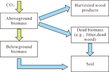
Fig.1
A conceptual diagram of carbon uptake through vegetation growth (green arrows) and carbon transfer (blue arrows) among major pools of forest ecosystems. Carbon can be released from each pool through abrupt (e.g., fire) or gradual (e.g., decay) processes. An inventory of forest carbon dynamics can be derived by summing up carbon changes in all pools (see Section 3.4)"

Tab.1
A partial list of process-based models for carbon studies (based on Literatures [39] and [52])"
| Model name | Developers/References |
|---|---|
| BEPS | Chen et al.[ |
| Biome-BGC | Bond-Lamberty et al.[ |
| Can-IBIS | Foley et al.[ |
| CASA | Randerson et al.[ |
| CASA GFEDv2 | van der Werf et al.[ |
| CENTURY | Parton et al.[ |
| CLM-CASA | Randerson et al.[ |
| CLM-CN | Thornton et al.[ |
| DLEM | Tian et al.[ |
| DNDC | Li et al.[ |
| ED | Hurtt et al.[ |
| EDCM | Liu et al.[ |
| FIRE-BGC | Keane et al.[ |
| FORCLIM | Bugmann[ |
| FOREST-BGC | Running and Gower[ |
| FVS | Dixon[ |
| HYBRID | Friend et al.[ |
| InTEC | Chen et al.[ |
| ISAM | Jain and Yang[ |
| LANDIS | Mladenoff[ |
| LINKAGES | Pastor and Post[ |
| LPJ-wsl | Sitch et al.[ |
| ORCHIDEE | Krinner et al.[ |
| SiB3 | Baker et al.[ |
| SORTIE | Pacala et al.[ |
| TEM | Raich et al.[ |
Tab.2
A partial list of variables/parameters important for estimating forest carbon dynamics that may be derivable using remote sensing technology"
| General category | Variable list |
|---|---|
| Plant characteristics | Foliar nitrogen, chlorophyll, lignin concentration, leaf area, leaf water content, stress/drought |
| Vegetation status | Stand age, species composition, canopy cover, height, volume, biomass |
| Vegetation dynamics | Land cover/use change, disturbance, management, harvested wood products, growth rates |
| Ecosystem fluxes | SIF, GPP, NPP, NEP, NBP/NEE, FAPAR, ER |
| Soil properties | Soil moisture, nutrient, soil organic carbon |
| Meteorological variables | Precipitation, temperature (including LST), ET, VPD, PAR |
| Atmospheric carbon | CO2, CH4 |
Tab.3
General methods and input data required for estimating major carbon pools of terrestrial ecosystems (based on IPCC[8])"
| Carbon pools | Estimation methods/input data |
|---|---|
| Aboveground biomass | Ground measurements, remote sensing, land use/disturbance |
| Belowground biomass | No change, or modeled based on aboveground biomass |
| Dead organic matter | No change, or modeled based on land use/disturbance data |
| Soil | No change, or modeled based on land use/disturbance data |
| Harvested wood products | FAO database, survey data, remote sensing based |
| [1] | IPCC. Climate change 2001: The scientific basis[M]. Cambridge: Cambridge University Press, 2001. |
| [2] | IPCC. Climate change 2007:synthesis report. Contribution of working groups Ⅰ, Ⅱ and Ⅲ to the fourth assessment report[M]. Geneva, Switzerland: IPCC, 2007. |
| [3] |
CHEN J M. Carbon neutrality: Toward a sustainable future[J]. The Innovation, 2021, 2(3): 100127.
doi: 10.1016/j.xinn.2021.100127 |
| [4] |
FAHEY T J, WOODBURY P B, BATTLES J J, et al. Forest carbon storage: ecology, management, and policy[J]. Frontiers in Ecology and the Environment, 2010, 8(5): 245-252.
doi: 10.1890/080169 |
| [5] |
AGRAWAL A, NEPSTAD D, CHHATRE A. Reducing emissions from deforestation and forest degradation[J]. Annual Review of Environment and Resources, 2011, 36: 373-396.
doi: 10.1146/annurev-environ-042009-094508 |
| [6] | CORBERA E, SCHROEDER H. Governing and implementing REDD+[J]. Environmental Science & Policy, 2011, 14(2): 89-99. |
| [7] |
KÖHL M, NEUPANE P R, MUNDHENK P. REDD+ measurement, reporting and verification—a cost trap? Implications for financing REDD+MRV costs by result-based payments[J]. Ecological Economics, 2020, 168: 106513.
doi: 10.1016/j.ecolecon.2019.106513 |
| [8] | IPCC. 2006 IPCC guidelines for national greenhouse gas inventories. volume 4: agriculture, forestry and other land use[Z]. Japan: IGES, 2006. |
| [9] | IPCC. 2019 Refinement to the 2006 IPCC Guidelines for National Greenhouse Gas Inventories. volume 4: agriculture, forestry and other land use[Z]. Switzerland: IPCC, 2019. |
| [10] |
JACKSON R B, BAKER J S. Opportunities and constraints for forest climate mitigation[J]. BioScience, 2010, 60(9): 698-707.
doi: 10.1525/bio.2010.60.9.7 |
| [11] |
RING I, DRECHSLER M, VAN TEEFFELEN A J, et al. Biodiversity conservation and climate mitigation: what role can economic instruments play?[J]. Current Opinion in Environmental Sustainability, 2010, 2(1-2): 50-58.
doi: 10.1016/j.cosust.2010.02.004 |
| [12] |
GRACE J. Understanding and managing the global carbon cycle[J]. Journal of Ecology, 2004, 92(2): 189-202.
doi: 10.1111/j.0022-0477.2004.00874.x |
| [13] |
SCHIMEL D S. Terrestrial ecosystems and the carbon cycle[J]. Global Change Biology, 1995, 1(1): 77-91.
doi: 10.1111/j.1365-2486.1995.tb00008.x |
| [14] |
SCHIMEL D, PAVLICK R, FISHER J B, et al. Observing terrestrial ecosystems and the carbon cycle from space[J]. Global Change Biology, 2015, 21(5): 1762-1776.
doi: 10.1111/gcb.12822 |
| [15] |
FRIEDLINGSTEIN P, O’SULLIVAN M, JONES M W, et al. Global carbon budget 2020[J]. Earth System Science Data, 2020, 12(4): 3269-3340.
doi: 10.5194/essd-12-3269-2020 |
| [16] |
LE QUÉRÉ C, ANDREW R M, FRIEDLINGSTEIN P, et al. Global carbon budget 2017[J]. Earth System Science Data, 2018, 10(1): 405-448.
doi: 10.5194/essd-10-405-2018 |
| [17] |
HOUGHTON R A. Balancing the global carbon budget[J]. Annual Review of Earth and Planetary Sciences, 2007, 35: 313-347.
doi: 10.1146/annurev.earth.35.031306.140057 |
| [18] |
BONAN G B. Forests and climate change: forcings, feedbacks, and the climate benefits of forests[J]. Science, 2008, 320(5882): 1444-1449.
doi: 10.1126/science.1155121 |
| [19] | HOUGHTON R A. Historic role of forests in the global carbon cycle[M]// KOHLMAIERG H, WEBERM, HOUGHTONR A. Carbon Dioxide Mitigation in Forestry and Wood Industry. Berlin: Springer, 1998: 1-24. |
| [20] |
LUYSSAERT S, INGLIMA I, JUNG M, et al. CO2 balance of boreal, temperate, and tropical forests derived from a global database[J]. Global Change Biology, 2007, 13(12): 2509-2537.
doi: 10.1111/j.1365-2486.2007.01439.x |
| [21] |
HOUGHTON R A, NASSIKAS A A. Global and regional fluxes of carbon from land use and land cover change 1850—2015[J]. Global Biogeochemical Cycles, 2017, 31(3): 456-472.
doi: 10.1002/2016GB005546 |
| [22] |
GOWARD S N, MASEK J G, COHEN W, et al. Forest disturbance and North American carbon flux[J]. Eos, Transactions American Geophysical Union, 2008, 89(11): 105-106.
doi: 10.1029/2008EO110001 |
| [23] |
IGBP Terrestrial Carbon Working Group, STEFFEN W, NOBLE I, et al. The terrestrial carbon cycle: implications for the Kyoto protocol[J]. Science, 1998, 280(5368): 1393-1394.
doi: 10.1126/science.280.5368.1393 |
| [24] | SKOG K E. Sequestration of carbon in harvested wood products for the United States[J]. Forest Products Journal, 2008, 58(6): 56-72. |
| [25] |
ZENG Ning. Carbon sequestration via wood burial[J]. Carbon Balance and Management, 2008, 3(1): 1.
doi: 10.1186/1750-0680-3-1 |
| [26] |
CANADELL J G, RAUPACH M R. Managing forests for climate change mitigation[J]. Science, 2008, 320(5882): 1456-1457.
doi: 10.1126/science.1155458 |
| [27] |
GOLDEN D, SMITH M A, COLOMBO S. Forest carbon management and carbon trading: a review of Canadian forest options for climate change mitigation[J]. The Forestry Chronicle, 2011, 87(5): 625-635.
doi: 10.5558/tfc2011-069 |
| [28] |
SCHULZE E D, VALENTINI R, SANZ M J. The long way from Kyoto to Marrakesh: implications of the Kyoto Protocol negotiations for global ecology[J]. Global Change Biology, 2002, 8(6): 505-518.
doi: 10.1046/j.1365-2486.2002.00523.x |
| [29] |
BIRDSEY R, PREGITZER K, LUCIER A. Forest carbon management in the United States[J]. Journal of Environmental Quality, 2006, 35(4): 1461-1469.
doi: 10.2134/jeq2005.0162 |
| [30] |
LAMB R L, HURTT G C, BOUDREAU T J, et al. Context and future directions for integrating forest carbon into sub-national climate mitigation planning in the RGGI region of the U.S.[J]. Environmental Research Letters, 2021, 16(6): 063001.
doi: 10.1088/1748-9326/abe6c2 |
| [31] |
BASTOS A, FRIEDLINGSTEIN P, SITCH S, et al. Impact of the 2015/2016 El Niño on the terrestrial carbon cycle constrained by bottom-up and top-down approaches[J]. Philosophical Transactions of the Royal Society B: Biological Sciences, 2018, 373(1760): 20170304.
doi: 10.1098/rstb.2017.0304 |
| [32] |
SCHIMEL D S, HOUSE J I, HIBBARD K A, et al. Recent patterns and mechanisms of carbon exchange by terrestrial ecosystems[J]. Nature, 2001, 414(6860): 169-172.
doi: 10.1038/35102500 |
| [33] |
HAYES D J, TURNER D P, STINSON G, et al. Reconciling estimates of the contemporary North American carbon balance among terrestrial biosphere models, atmospheric inversions, and a new approach for estimating net ecosystem exchange from inventory-based data[J]. Global Change Biology, 2012, 18(4): 1282-1299.
doi: 10.1111/j.1365-2486.2011.02627.x |
| [34] |
GURNEY K R, LAW R M, DENNING A S, et al. Towards robust regional estimates of CO2 sources and sinks using atmospheric transport models[J]. Nature, 2002, 415(6872): 626-630.
doi: 10.1038/415626a |
| [35] |
STEPHENS B B, GURNEY K R, TANS P P, et al. Weak northern and strong tropical land carbon uptake from vertical profiles of atmospheric CO2[J]. Science, 2007, 316(5832): 1732-1735.
doi: 10.1126/science.1137004 |
| [36] |
FAN S, GLOOR M, MAHLMAN J, et al. A large terrestrial carbon sink in North America implied by atmospheric and oceanic carbon dioxide data and models[J]. Science, 1998, 282(5388): 442-446.
doi: 10.1126/science.282.5388.442 |
| [37] |
PACALA S W, HURTT G C, BAKER D, et al. Consistent land- and atmosphere-based U.S. carbon sink estimates[J]. Science, 2001, 292(5525): 2316-2320.
doi: 10.1126/science.1057320 |
| [38] |
GURNEY K R, LAW R M, DENNING A S, et al. TransCom 3 CO2 inversion intercomparison: 1. annual mean control results and sensitivity to transport and prior flux information[J]. Tellus B: Chemical and Physical Meteorology, 2003, 55(2): 555-579.
doi: 10.3402/tellusb.v55i2.16728 |
| [39] |
HUNTZINGER D N, POST W M, WEI Y, et al. North American Carbon Program (NACP) regional interim synthesis: terrestrial biospheric model intercomparison[J]. Ecological Modelling, 2012, 232: 144-157.
doi: 10.1016/j.ecolmodel.2012.02.004 |
| [40] |
CHEN J M, LIU J, CIHLAR J, et al. Daily canopy photosynthesis model through temporal and spatial scaling for remote sensing applications[J]. Ecological Modelling, 1999, 124(2-3): 99-119.
doi: 10.1016/S0304-3800(99)00156-8 |
| [41] |
VAN DER WERF G R, RANDERSON J T, COLLATZ G J, et al. Continental-scale partitioning of fire emissions during the 1997 to 2001 El Nino/La Nina period[J]. Science, 2004, 303(5654): 73-76.
doi: 10.1126/science.1090753 |
| [42] | VAN DER WERF G R, RANDERSON J T, GIGLIO L, et al. Interannual variability in global biomass burning emissions from 1997 to 2004[J]. Atmospheric Chemistry and Physics, 2006, 6(11): 3423-3441. |
| [43] |
RANDERSON J T, THOMPSON M V, CONWAY T J, et al. The contribution of terrestrial sources and sinks to trends in the seasonal cycle of atmospheric carbon dioxide[J]. Global Biogeochemical Cycles, 1997, 11(4): 535-560.
doi: 10.1029/97GB02268 |
| [44] | JAIN A K, YANG Xiaojuan. Modeling the effects of two different land cover change data sets on the carbon stocks of plants and soils in concert with CO2 and climate change[J]. Global Biogeochemical Cycles, 2005, 19(2): GB2015. |
| [45] |
FOLEY J A, PRENTICE I C, RAMANKUTTY N, et al. An integrated biosphere model of land surface processes, terrestrial carbon balance, and vegetation dynamics[J]. Global Biogeochemical Cycles, 1996, 10(4): 603-628.
doi: 10.1029/96GB02692 |
| [46] |
THORNTON P E, DONEY S C, LINDSAY K, et al. Carbon-nitrogen interactions regulate climate-carbon cycle feedbacks: results from an atmosphere-ocean general circulation model[J]. Biogeosciences, 2009, 6(10): 2099-2120.
doi: 10.5194/bg-6-2099-2009 |
| [47] |
TIAN Hanqin, CHEN Guangsheng, LIU Mingliang, et al. Model estimates of net primary productivity, evapotranspiration, and water use efficiency in the terrestrial ecosystems of the southern United States during 1895—2007[J]. Forest Ecology and Management, 2010, 259(7): 1311-1327.
doi: 10.1016/j.foreco.2009.10.009 |
| [48] |
SITCH S, SMITH B, PRENTICE I C, et al. Evaluation of ecosystem dynamics, plant geography and terrestrial carbon cycling in the LPJ dynamic global vegetation model[J]. Global Change Biology, 2003, 9(2): 161-185.
doi: 10.1046/j.1365-2486.2003.00569.x |
| [49] | KRINNER G, VIOVY N, DE NOBLET-DUCOUDRÉN, et al. A dynamic global vegetation model for studies of the coupled atmosphere-biosphere system[J]. Global Biogeochemical Cycles, 2005, 19(1): GB1015. |
| [50] | BAKER I T, PRIHODKO L, DENNING A S, et al. Seasonal drought stress in the Amazon: reconciling models and observations[J]. Journal of Geophysical Research: Biogeosciences, 2008, 113(G1): G00B01. |
| [51] |
RAICH J W, RASTETTER E B, MELILLO J M, et al. Potential net primary productivity in South America: application of a global model[J]. Ecological Applications, 1991, 1(4): 399-429.
doi: 10.2307/1941899 |
| [52] | LIU Shuguang, BOND-LAMBERTY B, HICKE J A, et al. Simulating the impacts of disturbances on forest carbon cycling in North America: processes, data, models, and challenges[J]. Journal of Geophysical Research: Biogeosciences, 2011, 116(G4): G00K08. |
| [53] |
JU Weimin, CHEN J M, BLACK T A, et al. Modelling multi-year coupled carbon and water fluxes in a boreal aspen forest[J]. Agricultural and Forest Meteorology, 2006, 140(1-4): 136-151.
doi: 10.1016/j.agrformet.2006.08.008 |
| [54] |
BOND-LAMBERTY B, GOWER S T, AHL D E, et al. Reimplementation of the Biome-BGC model to simulate successional change[J]. Tree Physiology, 2005, 25(4): 413-424.
doi: 10.1093/treephys/25.4.413 |
| [55] |
KUCHARIK C J, FOLEY J A, DELIRE C, et al. Testing the performance of a dynamic global ecosystem model: water balance, carbon balance, and vegetation structure[J]. Global Biogeochemical Cycles, 2000, 14(3): 795-825.
doi: 10.1029/1999GB001138 |
| [56] | PARTON W J, OJIMA D S, COLE C V, et al. A general model for soil organic matter dynamics: sensitivity to litter chemistry, texture and management[M]// BRYANTR B, ARNOLDR W. Quantitative Modeling of Soil Forming Processes.Soil Science Society of America, 1994, 39: 147-167. |
| [57] |
RANDERSON J T, HOFFMAN F M, THORNTON P E, et al. Systematic assessment of terrestrial biogeochemistry in coupled climate-carbon models[J]. Global Change Biology, 2009, 15(10): 2462-2484.
doi: 10.1111/j.1365-2486.2009.01912.x |
| [58] |
LI Changsheng, FROLKING S, CROCKER G J, et al. Simulating trends in soil organic carbon in long-term experiments using the DNDC model[J]. Geoderma, 1997, 81(1-2): 45-60.
doi: 10.1016/S0016-7061(97)00080-3 |
| [59] |
HURTT G C, MOORCROFT P R, AND S W P, et al. Terrestrial models and global change: challenges for the future[J]. Global Change Biology, 1998, 4(5): 581-590.
doi: 10.1046/j.1365-2486.1998.t01-1-00203.x |
| [60] |
MOORCROFT P R, HURTT G C, PACALA S W. A method for scaling vegetation dynamics: the ecosystem demography model[J]. Ecological Monographs, 2001, 71(4): 557-586.
doi: 10.1890/0012-9615(2001)071[0557:AMFSVD]2.0.CO;2 |
| [61] | LIU Shuguang, BLISS N, SUNDQUIST E, et al. Modeling carbon dynamics in vegetation and soil under the impact of soil erosion and deposition[J]. Global Biogeochemical Cycles, 2003, 17(2): 1074. |
| [62] |
KEANE R E, RYAN K C, RUNNING S W. Simulating effects of fire on northern Rocky Mountain landscapes with the ecological process model FIRE-BGC[J]. Tree Physiology, 1996, 16(3): 319-331.
doi: 10.1093/treephys/16.3.319 |
| [63] | BUGMANN H. On the ecology of mountainous forests in a changing climate: a simulation study[D]. Zurich: ETH Zurich, 1994. |
| [64] |
RUNNING S W, GOWER S T. FOREST-BGC, A general model of forest ecosystem processes for regional applications. II. Dynamic carbon allocation and nitrogen budgets[J]. Tree Physiology, 1991, 9(1-2): 147-160.
doi: 10.1093/treephys/9.1-2.147 |
| [65] | DIXON G E. Essential FVS: A user’s guide to the forest vegetation simulator[R]. Fort Collins, CO: US Department of Agriculture, Forest Service, Forest Management Service Center, 2002. |
| [66] |
FRIEND A D, STEVENS A K, KNOX R G, et al. A process-based, terrestrial biosphere model of ecosystem dynamics (Hybrid v3.0)[J]. Ecological Modelling, 1997, 95(2-3): 249-287.
doi: 10.1016/S0304-3800(96)00034-8 |
| [67] |
CHEN Wenjun, CHEN Jing, CIHLAR J. An integrated terrestrial ecosystem carbon-budget model based on changes in disturbance, climate, and atmospheric chemistry[J]. Ecological Modelling, 2000, 135(1): 55-79.
doi: 10.1016/S0304-3800(00)00371-9 |
| [68] |
MLADENOFF D J. LANDIS and forest landscape models[J]. Ecological Modelling, 2004, 180(1): 7-19.
doi: 10.1016/j.ecolmodel.2004.03.016 |
| [69] |
PASTOR J, POST W M. Influence of climate, soil moisture, and succession on forest carbon and nitrogen cycles[J]. Biogeochemistry, 1986, 2(1): 3-27.
doi: 10.1007/BF02186962 |
| [70] |
BONDEAU A, SMITH P C, ZAEHLE S, et al. Modelling the role of agriculture for the 20th century global terrestrial carbon balance[J]. Global Change Biology, 2007, 13(3): 679-706.
doi: 10.1111/j.1365-2486.2006.01305.x |
| [71] |
PACALA S W, CANHAM C D, SAPONARA J, et al. Forest models defined by field measurements: estimation, error analysis and dynamics[J]. Ecological Monographs, 1996, 66(1): 1-43.
doi: 10.2307/2963479 |
| [72] |
MCGUIRE A D, MELILLO J M, JOYCE L A, et al. Interactions between carbon and nitrogen dynamics in estimating net primary productivity for potential vegetation in North America[J]. Global Biogeochemical Cycles, 1992, 6(2): 101-124.
doi: 10.1029/92GB00219 |
| [73] | PAN Y, CHEN J M, BIRDSEY R, et al. Age structure and disturbance legacy of North American forests[J]. Biogeosciences Discussions, 2010, 7(1): 979-1020. |
| [74] |
NORBY R J, OGLE K, CURTIS P S, et al. Aboveground growth and competition in forest gap models: an analysis for studies of climatic change[J]. Climatic Change, 2001, 51(3): 415-447.
doi: 10.1023/A:1012510619424 |
| [75] |
LAW B E, TURNER D, CAMPBELL J, et al. Disturbance and climate effects on carbon stocks and fluxes across Western Oregon USA[J]. Global Change Biology, 2004, 10(9): 1429-1444.
doi: 10.1111/j.1365-2486.2004.00822.x |
| [76] |
WANG Weile, ICHII K, HASHIMOTO H, et al. A hierarchical analysis of terrestrial ecosystem model Biome-BGC: equilibrium analysis and model calibration[J]. Ecological Modelling, 2009, 220(17): 2009-2023.
doi: 10.1016/j.ecolmodel.2009.04.051 |
| [77] |
BUGMANN H. A review of forest gap models[J]. Climatic Change, 2001, 51(3-4): 259-305.
doi: 10.1023/A:1012525626267 |
| [78] |
WULLSCHLEGER S D, JACKSON R B, CURRIE W S, et al. Below-ground processes in gap models for simulating forest response to global change[J]. Climatic Change, 2001, 51(3-4): 449-473.
doi: 10.1023/A:1012570821241 |
| [79] | HURTT G C, PACALA S W, MOORCROFT P R, et al. Projecting the future of the U.S. carbon sink[J]. Proceedings of the National Academy of Sciences of the United States of America, 2002, 99(3): 1389-1394. |
| [80] |
CROOKSTON N L, REHFELDT G E, DIXON G E, et al. Addressing climate change in the forest vegetation simulator to assess impacts on landscape forest dynamics[J]. Forest Ecology and Management, 2010, 260(7): 1198-1211.
doi: 10.1016/j.foreco.2010.07.013 |
| [81] |
HOUGHTON R A. Land-use change and the carbon cycle[J]. Global Change Biology, 1995, 1(4): 275-287.
doi: 10.1111/j.1365-2486.1995.tb00026.x |
| [82] |
HOUGHTON R A. How well do we know the flux of CO2 from land-use change?[J]. Tellus B: Chemical and Physical Meteorology, 2010, 62(5): 337-351.
doi: 10.1111/j.1600-0889.2010.00473.x |
| [83] |
HOUGHTON R A, HOBBIE J E, MELILLO J M, et al. Changes in the carbon content of terrestrial biota and soils between 1860 and 1980: A net release of CO2 to the atmosphere[J]. Ecological Monographs, 1983, 53(3): 235-262.
doi: 10.2307/1942531 |
| [84] |
HOUGHTON R A. The annual net flux of carbon to the atmosphere from changes in land use 1850—1990[J]. Tellus B: Chemical and Physical Meteorology, 1999, 51(2): 298-313.
doi: 10.3402/tellusb.v51i2.16288 |
| [85] | HOUGHTON R A. Revised estimates of the annual net flux of carbon to the atmosphere from changes in land use and land management 1850—2000[J]. Tellus B: Chemical and Physical Meteorology, 2003, 55(2): 378-390. |
| [86] |
HOUGHTON R A, HACKLER J L, LAWRENCE K T. The U.S. carbon budget: contributions from land-use change[J]. Science, 1999, 285(5427): 574-578.
doi: 10.1126/science.285.5427.574 |
| [87] | HOUGHTON R A, HACKLER J L. Sources and sinks of carbon from land-use change in China[J]. Global Biogeochemical Cycles, 2003, 17(2): 1034. |
| [88] |
HOUGHTON R A, SKOLE D L, NOBRE C A, et al. Annual fluxes of carbon from deforestation and regrowth in the Brazilian Amazon[J]. Nature, 2000, 403(6767): 301-304.
doi: 10.1038/35002062 |
| [89] |
HARRIS N L, BROWN S, HAGEN S C, et al. Baseline map of carbon emissions from deforestation in tropical regions[J]. Science, 2012, 336(6088): 1573-1576.
doi: 10.1126/science.1217962 |
| [90] |
ANDERSEN L E, DOYLE A S, GRANADO S D, et al. Net carbon emissions from deforestation in Bolivia during 1990—2000 and 2000—2010: Results from a Carbon Bookkeeping Model[J]. PLoS One, 2016, 11(3): e0151241.
doi: 10.1371/journal.pone.0151241 |
| [91] |
BACCINI A, GOETZ S J, WALKER W S, et al. Estimated carbon dioxide emissions from tropical deforestation improved by carbon-density maps[J]. Nature Climate Change, 2012, 2(3): 182-185.
doi: 10.1038/nclimate1354 |
| [92] | ACHARD F, EVA H D, MAYAUX P, et al. Improved estimates of net carbon emissions from land cover change in the tropics for the 1990s[J]. Global Biogeochemical Cycles, 2004, 18(2): GB2008. |
| [93] |
HANSIS E, DAVIS S J, PONGRATZ J. Relevance of methodological choices for accounting of land use change carbon fluxes[J]. Global Biogeochemical Cycles, 2015, 29(8): 1230-1246.
doi: 10.1002/2014GB004997 |
| [94] |
GASSER T, CIAIS P. A theoretical framework for the net land-to-atmosphere CO2 flux and its implications in the definition of “emissions from land-use change”[J]. Earth System Dynamics, 2013, 4(1): 171-186.
doi: 10.5194/esd-4-171-2013 |
| [95] |
REICK C, RADDATZ T, PONGRATZ J, et al. Contribution of anthropogenic land cover change emissions to pre-industrial atmospheric CO2[J]. Tellus B: Chemical and Physical Meteorology, 2010, 62(5): 329-336.
doi: 10.1111/j.1600-0889.2010.00479.x |
| [96] | SHEVLIAKOVA E, STOUFFER R J, MALYSHEV S, et al. Historical warming reduced due to enhanced land carbon uptake[C]//Proceedings of the National Academy of Sciences of the United States of America, 2013, 110(42): 16730-16735. |
| [97] |
STOCKER B D, FEISSLI F, STRASSMANN K M, et al. Past and future carbon fluxes from land use change, shifting cultivation and wood harvest[J]. Tellus B: Chemical and Physical Meteorology, 2014, 66(1): 23188.
doi: 10.3402/tellusb.v66.23188 |
| [98] |
WILKENSKJELD S, KLOSTER S, PONGRATZ J, et al. Comparing the influence of net and gross anthropogenic land-use and land-cover changes on the carbon cycle in the MPI-ESM[J]. Biogeosciences, 2014, 11(17): 4817-4828.
doi: 10.5194/bg-11-4817-2014 |
| [99] |
TANG Xiaojing, HUTYRA L R, ARÉVALO P, et al. Spatiotemporal tracking of carbon emissions and uptake using time series analysis of Landsat data: a spatially explicit carbon bookkeeping model[J]. Science of the Total Environment, 2020, 720: 137409.
doi: 10.1016/j.scitotenv.2020.137409 |
| [100] |
TANG Xiaojing, WOODCOCK C E, OLOFSSON P, et al. Spatiotemporal assessment of land use/land cover change and associated carbon emissions and uptake in the Mekong River Basin[J]. Remote Sensing of Environment, 2021, 256: 112336.
doi: 10.1016/j.rse.2021.112336 |
| [101] |
GILLIS M D, OMULE A Y, BRIERLEY T. Monitoring Canada’s forests: the national forest inventory[J]. The Forestry Chronicle, 2005, 81(2): 214-221.
doi: 10.5558/tfc81214-2 |
| [102] | NELSON M, MOISEN G, FINCO M, et al. Forest inventory and analysis in the United States: remote sensing and geospatial activities[J]. Photogrammetric Engineering and Remote Sensing, 2007, 73(7): 729-732. |
| [103] | SMITH W B. Forest inventory and analysis: a national inventory and monitoring program[J]. Environmental Pollution, 2002, 116(S1): S233-S242. |
| [104] |
JENKINS J C, BIRDSEY R A, PAN Yude. Biomass and NPP estimation for the mid-Atlantic region (USA) using plot-level forest inventory data[J]. Ecological Applications, 2001, 11(4): 1174-1193.
doi: 10.1890/1051-0761(2001)011[1174:BANEFT]2.0.CO;2 |
| [105] | JENKINS J C, CHOJNACKY D C, HEATH L S, et al. National scale biomass estimators for United States tree species[J]. Forest Science, 2003, 49(1): 12-35. |
| [106] | BIRDSEY R A. Carbon storage and accumulation in United States forest ecosystems[R]. Washington, DC: U.S. Department of Agriculture, Forest Service, 1992. |
| [107] | BIRDSEY R A, HEATH L S. Carbon changes in U.S. forests[M]// JOYCEL A. Productivity of America’s Forests and Climate Change. Fort Collins, Colorado: USDA, Forest Service: 1995: 56-70. |
| [108] |
TURNER D P, KOERPER G J, HARMON M E, et al. A carbon budget for forests of the conterminous United States[J]. Ecological Applications, 1995, 5(2): 421-436.
doi: 10.2307/1942033 |
| [109] | HEATH L S, SMITH J E, SKOG K E, et al. Managed forest carbon estimates for the US greenhouse gas inventory, 1990-2008[J]. Journal of Forestry, 2011, 109(3): 167-173. |
| [110] | SMITH J E, HEATH L S, SKOG K E, et al. Methods for calculating forest ecosystem and harvested carbon with standard estimates for forest types of the United States[R]. Newtown Square, PA: USDA, Forest Service, 2006. |
| [111] |
STINSON G, KURZ W A, SMYTH C E, et al. An inventory-based analysis of Canada’s managed forest carbon dynamics, 1990 to 2008[J]. Global Change Biology, 2011, 17(6): 2227-2244.
doi: 10.1111/j.1365-2486.2010.02369.x |
| [112] |
SHVIDENKO A, NILSSON S. Dynamics of Russian forests and the carbon budget in 1961—1998: An assessment based on long-term forest inventory data[J]. Climatic Change, 2002, 55(1-2): 5-37.
doi: 10.1023/A:1020243304744 |
| [113] |
JANSSENS I A, FREIBAUER A, CIAIS P, et al. Europe’s terrestrial biosphere absorbs 7% to 12% of European anthropogenic CO2 emissions[J]. Science, 2003, 300(5625): 1538-1542.
doi: 10.1126/science.1083592 |
| [114] |
NABUURS G J, SCHELHAAS M J, MOHREN G F M J, et al. Temporal evolution of the European forest sector carbon sink from 1950 to 1999[J]. Global Change Biology, 2003, 9(2): 152-160.
doi: 10.1046/j.1365-2486.2003.00570.x |
| [115] | BIRDSEY R. Data gaps for monitoring forest carbon in the United States: an inventory perspective[J]. Environmental Management, 2004, 33(1): S1-S8. |
| [116] |
ŤUPEK B, ZANCHI G, VERKERK P J. et al. A comparison of alternative modelling approaches to evaluate the European forest carbon fluxes[J]. Forest Ecology and Management, 2010, 260(3): 241-251.
doi: 10.1016/j.foreco.2010.01.045 |
| [117] | WOODALL C W, COULSTON J W, DOMKE G M, et al. The U.S. forest carbon accounting framework: stocks and stock change, 1990—2016[R]. Newtown Square, PA: U.S. Department of Agriculture, Forest Service, Northern Research Station, 2015. |
| [118] |
KURZ W A, DYMOND C C, WHITE T M, et al. CBM-CFS3: A model of carbon-dynamics in forestry and land-use change implementing IPCC standards[J]. Ecological Modelling, 2009, 220(4): 480-504.
doi: 10.1016/j.ecolmodel.2008.10.018 |
| [119] |
RICHARDS G P, EVANS D M W. Development of a carbon accounting model (FullCAM Vers. 1. 0) for the Australian continent[J]. Australian Forestry, 2004, 67(4): 277-283.
doi: 10.1080/00049158.2004.10674947 |
| [120] |
PETRESCU A M R, PETERS G P, JANSSENS-MAENHOUT G, et al. European anthropogenic AFOLU greenhouse gas emissions: a review and benchmark data[J]. Earth System Science Data, 2020, 12(2): 961-1001.
doi: 10.5194/essd-12-961-2020 |
| [121] | UMEMIYA C, WHITE M, AMELLINA A, et al. National greenhouse gas inventory capacity: an assessment of Asian developing countries[J]. Environmental Science & Policy, 2017, 78: 66-73. |
| [122] |
XIAO Jingfeng, CHEVALLIER F, GOMEZ C, et al. Remote sensing of the terrestrial carbon cycle: a review of advances over 50 years[J]. Remote Sensing of Environment, 2019, 233: 111383.
doi: 10.1016/j.rse.2019.111383 |
| [123] |
HILKER T, COOPS N C, WULDER M A, et al. The use of remote sensing in light use efficiency based models of gross primary production: a review of current status and future requirements[J]. Science of the Total Environment, 2008, 404(2-3): 411-423.
doi: 10.1016/j.scitotenv.2007.11.007 |
| [124] |
LADONI M, BAHRAMI H A, ALAVIPANAH S K, et al. Estimating soil organic carbon from soil reflectance: a review[J]. Precision Agriculture, 2010, 11(1): 82-99.
doi: 10.1007/s11119-009-9123-3 |
| [125] |
GOETZ S, DUBAYAH R. Advances in remote sensing technology and implications for measuring and monitoring forest carbon stocks and change[J]. Carbon Management, 2011, 2(3): 231-244.
doi: 10.4155/cmt.11.18 |
| [126] |
RYU Y, BERRY J A, BALDOCCHI D D. What is global photosynthesis? History, uncertainties and opportunities[J]. Remote Sensing of Environment, 2019, 223: 95-114.
doi: 10.1016/j.rse.2019.01.016 |
| [127] |
GONG Weishu, HUANG Chengquan, HOUGHTON R A, et al. Carbon fluxes from contemporary forest disturbances in North Carolina evaluated using a grid-based carbon accounting model and fine resolution remote sensing products[J]. Science of Remote Sensing, 2022, 5: 100042.
doi: 10.1016/j.srs.2022.100042 |
| [128] |
WULDER M A, LOVELAND T R, ROY D P, et al. Current status of Landsat program, science, and applications[J]. Remote Sensing of Environment, 2019, 225: 127-147.
doi: 10.1016/j.rse.2019.02.015 |
| [129] |
LOVELAND T R, DWYER J L. Landsat: bilding a strong future[J]. Remote Sensing of Environment, 2012, 122: 22-29.
doi: 10.1016/j.rse.2011.09.022 |
| [130] |
DABBOOR M, OLTHOF I, MAHDIANPARI M, et al. The RADARSAT constellation mission core applications: first results[J]. Remote Sensing, 2022, 14(2): 301.
doi: 10.3390/rs14020301 |
| [131] |
ROSENQVIST A, SHIMADA M, SUZUKI S, et al. Operational performance of the ALOS global systematic acquisition strategy and observation plans for ALOS-2 PALSAR-2[J]. Remote Sensing of Environment, 2014, 155: 3-12.
doi: 10.1016/j.rse.2014.04.011 |
| [132] | WOODCOCK C E, ALLEN R, ANDERSON M, et al. Free access to landsat imagery[J]. Science, 2008, 320(5879): 1011. |
| [133] |
DRUSCH M, DEL BELLO U, CARLIER S, et al. Sentinel-2: ESA’s optical high-resolution mission for GMES operational services[J]. Remote Sensing of Environment, 2012, 120: 25-36.
doi: 10.1016/j.rse.2011.11.026 |
| [134] |
POTIN P, ROSICH B, MIRANDA N, et al. Sentinel-1 mission status[J]. Procedia Computer Science, 2016, 100: 1297-1304.
doi: 10.1016/j.procs.2016.09.245 |
| [135] |
NEUENSCHWANDER A, PITTS K. The ATL08 land and vegetation product for the ICESat-2 Mission[J]. Remote Sensing of Environment, 2019, 221: 247-259.
doi: 10.1016/j.rse.2018.11.005 |
| [136] |
DUBAYAH R, BLAIR J B, GOETZ S, et al. The global ecosystem dynamics investigation: high-resolution laser ranging of the Earth’s forests and topography[J]. Science of Remote Sensing, 2020, 1: 100002.
doi: 10.1016/j.srs.2020.100002 |
| [137] |
HOUGHTON R A. Aboveground forest biomass and the global carbon balance[J]. Global Change Biology, 2005, 11(6): 945-958.
doi: 10.1111/j.1365-2486.2005.00955.x |
| [138] | HOUGHTON R A, HALL F, GOETZ S J. Importance of biomass in the global carbon cycle[J]. Journal of Geophysical Research: Biogeosciences, 2009, 114(G2): G00E03. |
| [139] | DUBAYAH R O, DRAKE J B. Lidar remote sensing for forestry[J]. Journal of Forestry, 2000, 98(6): 44-46. |
| [140] |
LEFSKY M A, COHEN W B, ACKER S A, et al. Lidar remote sensing of the canopy structure and biophysical properties of douglas-fir western hemlock forests[J]. Remote Sensing of Environment, 1999, 70(3): 339-361.
doi: 10.1016/S0034-4257(99)00052-8 |
| [141] |
LEFSKY M A, COHEN W B, HARDING D J, et al. Lidar remote sensing of above-ground biomass in three biomes[J]. Global Ecology and Biogeography, 2002, 11(5): 393-399.
doi: 10.1046/j.1466-822x.2002.00303.x |
| [142] |
NELSON R, MARGOLIS H, MONTESANO P, et al. Lidar-based estimates of aboveground biomass in the continental US and Mexico using ground, airborne, and satellite observations[J]. Remote Sensing of Environment, 2017, 188: 127-140.
doi: 10.1016/j.rse.2016.10.038 |
| [143] |
PANG Yong, WANG Weiwei, DU Liming, et al. Nyström-based spectral clustering using airborne LiDAR point cloud data for individual tree segmentation[J]. International Journal of Digital Earth, 2021, 14(10): 1452-1476.
doi: 10.1080/17538947.2021.1943018 |
| [144] |
WANG Qiang, PANG Yong, CHEN Dongsheng, et al. Lidar biomass index: a novel solution for tree-level biomass estimation using 3D crown information[J]. Forest Ecology and Management, 2021, 499: 119542.
doi: 10.1016/j.foreco.2021.119542 |
| [145] |
PANG Yong, LI Zengyuan. Inversion of biomass components of the temperate forest using airborne Lidar technology in Xiaoxing’an Mountains, Northeastern of China[J]. Chinese Journal of Plant Ecology, 2012, 36(10): 1095-1105.
doi: 10.3724/SP.J.1258.2012.01095 |
| [146] | PANG Yong, LI Zengyuan, MENG Shili, et al. China typical forest aboveground biomass estimation by fusion of multi-platform data[C]//Proceedings of the 2016 IEEE International Geoscience and Remote Sensing Symposium (IGARSS). Beijing: IEEE, 2016: 3557-3560. |
| [147] |
PANG Yong, LI Zengyuan. Subtropical forest biomass estimation using airborne LiDAR and Hyperspectral data[J]. The International Archives of the Photogrammetry, Remote Sensing and Spatial Information Sciences, 2016, XLI-B8: 747-749.
doi: 10.5194/isprs-archives-XLI-B8-747-2016 |
| [148] |
RIGNOT E, WAY J B, MCDONALD K, et al. Monitoring of environmental conditions in Taiga forests using ERS-1 SAR[J]. Remote Sensing of Environment, 1994, 49(2): 145-154.
doi: 10.1016/0034-4257(94)90051-5 |
| [149] |
NEEFF T, DE ALENCASTRO GRAÇA P M, DUTRA L V, et al. Carbon budget estimation in Central Amazonia: Successional forest modeling from remote sensing data[J]. Remote Sensing of Environment, 2005, 94(4): 508-522.
doi: 10.1016/j.rse.2004.12.002 |
| [150] |
RAUSTE Y. Multi-temporal JERS SAR data in boreal forest biomass mapping[J]. Remote Sensing of Environment, 2005, 97(2): 263-275.
doi: 10.1016/j.rse.2005.05.002 |
| [151] |
PULLIAINEN J, ENGDAHL M, HALLIKAINEN M. Feasibility of multi-temporal interferometric SAR data for stand-level estimation of boreal forest stem volume[J]. Remote Sensing of Environment, 2003, 85(4): 397-409.
doi: 10.1016/S0034-4257(03)00016-6 |
| [152] | PATENAUDE G, MILNE R, DAWSON T P. Synthesis of remote sensing approaches for forest carbon estimation: reporting to the Kyoto Protocol[J]. Environmental Science & Policy, 2005, 8(2): 161-178. |
| [153] |
AUSTIN J M, MACKEY B G, VAN NIEL K P. Estimating forest biomass using satellite radar: an exploratory study in a temperate Australian Eucalyptus forest[J]. Forest Ecology and Management, 2003, 176(1-3): 575-583.
doi: 10.1016/S0378-1127(02)00314-6 |
| [154] |
BALZTER H, SKINNER L, LUCKMAN A, et al. Estimation of tree growth in a conifer plantation over 19 years from multi-satellite L-band SAR[J]. Remote Sensing of Environment, 2003, 84(2): 184-191.
doi: 10.1016/S0034-4257(02)00106-2 |
| [155] |
SANTOS J R, FREITAS C C, ARAUJO L S, et al. Airborne P-band SAR applied to the aboveground biomass studies in the Brazilian tropical rainforest[J]. Remote Sensing of Environment, 2003, 87(4): 482-493.
doi: 10.1016/j.rse.2002.12.001 |
| [156] | RAUSTE Y. Multi-temporal JERS SAR data in boreal forest biomass mapping[J]. Remote Sensing of Environment, 2005, 97(2): 263-275. |
| [157] |
FRANSSON J E S, WALTER F, ULANDER L M H. Estimation of forest parameters using CARABAS-II VHF SAR data[J]. IEEE Transactions on Geoscience and Remote Sensing, 2000, 38(2): 720-727.
doi: 10.1109/36.842001 |
| [158] |
SANTOS J R, FREITAS C C, ARAUJO L S, et al. Airborne P-band SAR applied to the aboveground biomass studies in the Brazilian tropical rainforest[J]. Remote Sensing of Environment, 2003, 87(4): 482-493.
doi: 10.1016/j.rse.2002.12.001 |
| [159] |
SCHRÖDER R, PULS J, HAJNSEK I, et al. MAPSAR: a small L-band SAR mission for land observation[J]. Acta Astronautica, 2005, 56(1-2): 35-43.
doi: 10.1016/j.actaastro.2004.09.007 |
| [160] |
BALZTER H, SKINNER L, LUCKMAN A, et al. Estimation of tree growth in a conifer plantation over 19 years from multi-satellite L-band SAR[J]. Remote Sensing of Environment, 2003, 84(2): 184-191.
doi: 10.1016/S0034-4257(02)00106-2 |
| [161] |
CASTEL T, GUERRA F, CARAGLIO Y, et al. Retrieval biomass of a large Venezuelan pine plantation using JERS-1 SAR data. Analysis of forest structure impact on radar signature[J]. Remote Sensing of Environment, 2002, 79(1): 30-41.
doi: 10.1016/S0034-4257(01)00236-X |
| [162] |
DONOGHUE D N M, WATT P J. Using LiDAR to compare forest height estimates from IKONOS and Landsat ETM+ data in Sitka spruce plantation forests[J]. International Journal of Remote Sensing, 2006, 27(11): 2161-2175.
doi: 10.1080/01431160500396493 |
| [163] |
HYYPPÄ J, HYYPPÄ H, INKINEN M, et al. Accuracy comparison of various remote sensing data sources in the retrieval of forest stand attributes[J]. Forest Ecology and Management, 2000, 128(1-2): 109-120.
doi: 10.1016/S0378-1127(99)00278-9 |
| [164] |
MENG Shili, PANG Yong, ZHANG Zhongjun, et al. Mapping aboveground biomass using texture indices from aerial photos in a temperate forest of northeastern China[J]. Remote Sensing, 2016, 8(3): 230.
doi: 10.3390/rs8030230 |
| [165] |
POWELL S L, COHEN W B, HEALEY S P, et al. Quantification of live aboveground forest biomass dynamics with Landsat time-series and field inventory data: a comparison of empirical modeling approaches[J]. Remote Sensing of Environment, 2010, 114(5): 1053-1068.
doi: 10.1016/j.rse.2009.12.018 |
| [166] |
JI Lei, WYLIE B K, NOSSOV D R, et al. Estimating aboveground biomass in interior Alaska with Landsat data and field measurements[J]. International Journal of Applied Earth Observation and Geoinformation, 2012, 18: 451-461.
doi: 10.1016/j.jag.2012.03.019 |
| [167] |
MATASCI G, HERMOSILLA T, WULDER M A, et al. Large-area mapping of Canadian boreal forest cover, height, biomass and other structural attributes using Landsat composites and lidar plots[J]. Remote Sensing of Environment, 2018, 209: 90-106.
doi: 10.1016/j.rse.2017.12.020 |
| [168] | KELLNDORFER J, WALKER W, KIRSCH K, et al. NACP aboveground biomass and carbon baseline data, V. 2 (NBCD 2000), U.S.A., 2000[R]. Oak Ridge, Tennessee: ORNL Distributed Active Archive Center, 2013. |
| [169] |
BLACKARD J A, FINCO M V, HELMER E H, et al. Mapping U.S. forest biomass using nationwide forest inventory data and moderate resolution information[J]. Remote Sensing of Environment, 2008, 112(4): 1658-1677.
doi: 10.1016/j.rse.2007.08.021 |
| [170] |
WILSON B T, WOODALL C W, GRIFFITH D M. Imputing forest carbon stock estimates from inventory plots to a nationally continuous coverage[J]. Carbon Balance and Management, 2013, 8(1): 1.
doi: 10.1186/1750-0680-8-1 |
| [171] | ZHANG Xiaoyang, KONDRAGUNTA S. Estimating forest biomass in the USA using generalized allometric models and MODIS land products[J]. Geophysical Research Letters, 2006, 33(9): L09402. |
| [172] |
CHI Hong, SUN Guoqing, HUANG Jinliang, et al. National forest aboveground biomass mapping from ICESat/GLAS data and MODIS imagery in China[J]. Remote Sensing, 2015, 7(5): 5534-5564.
doi: 10.3390/rs70505534 |
| [173] |
SU Yanjun, GUO Qinghua, XUE Baolin, et al. Spatial distribution of forest aboveground biomass in China: estimation through combination of spaceborne lidar, optical imagery, and forest inventory data[J]. Remote Sensing of Environment, 2016, 173: 187-199.
doi: 10.1016/j.rse.2015.12.002 |
| [174] |
BACCINI A, LAPORTE N, GOETZ S J, et al. A first map of tropical Africa’s above-ground biomass derived from satellite imagery[J]. Environmental Research Letters, 2008, 3(4): 045011.
doi: 10.1088/1748-9326/3/4/045011 |
| [175] | SAATCHI S S, HARRIS N L, BROWN S, et al. Benchmark map of forest carbon stocks in tropical regions across three continents[J]. Proceedings of the National Academy of Sciences of the United States of America, 2011, 108(24): 9899-9904. |
| [176] |
HUANG Huabing, LIU Caixia, WANG Xiaoyi, et al. Integration of multi-resource remotely sensed data and allometric models for forest aboveground biomass estimation in China[J]. Remote Sensing of Environment, 2019, 221: 225-234.
doi: 10.1016/j.rse.2018.11.017 |
| [177] |
HEALEY S P, YANG Zhiqiang, GORELICK N, et al. Highly local model calibration with a new GEDI LiDAR asset on google earth engine reduces landsat forest height signal saturation[J]. Remote Sensing, 2020, 12(17): 2840.
doi: 10.3390/rs12172840 |
| [178] |
DUNCANSON L, KELLNER J R, ARMSTON J, et al. Aboveground biomass density models for NASA’s Global Ecosystem Dynamics Investigation (GEDI) lidar mission[J]. Remote Sensing of Environment, 2022, 270: 112845.
doi: 10.1016/j.rse.2021.112845 |
| [179] |
SAARELA S, HOLM S, HEALEY S P, et al. Generalized hierarchical model-based estimation for aboveground biomass assessment using GEDI and landsat data[J]. Remote Sensing, 2018, 10(11): 1832.
doi: 10.3390/rs10111832 |
| [180] |
DUNCANSON L, NEUENSCHWANDER A, HANCOCK S, et al. Biomass estimation from simulated GEDI, ICESat-2 and NISAR across environmental gradients in Sonoma County, California[J]. Remote Sensing of Environment, 2020, 242: 111779.
doi: 10.1016/j.rse.2020.111779 |
| [181] |
SILVA C A, DUNCANSON L, HANCOCK S, et al. Fusing simulated GEDI, ICESat-2 and NISAR data for regional aboveground biomass mapping[J]. Remote Sensing of Environment, 2021, 253: 112234.
doi: 10.1016/j.rse.2020.112234 |
| [182] |
ALBINET C, WHITEHURST A S, JEWELL L A, et al. A joint ESA-NASA Multi-mission Algorithm and Analysis Platform (MAAP) for biomass, NISAR, and GEDI[J]. Surveys in Geophysics, 2019, 40(4): 1017-1027.
doi: 10.1007/s10712-019-09541-z |
| [183] | LI A, et al. Mapping forest height for Mississippi using long-term landsat observations and GLAS data[EB/OL]. [2022-04-12] https://cce.nasa.gov/meeting_te_2010/abs_and_discussions/te2010_ab_searchab_id108.html |
| [184] |
NEIGH C S R, MASEK J G, BOURGET P, et al. Deciphering the precision of stereo IKONOS canopy height models for US forests with G-LiHT airborne LiDAR[J]. Remote Sensing, 2014, 6(3): 1762-1782.
doi: 10.3390/rs6031762 |
| [185] |
POTAPOV P, LI Xinyuan, HERNANDEZ-SERNA A, et al. Mapping global forest canopy height through integration of GEDI and Landsat data[J]. Remote Sensing of Environment, 2021, 253: 112165.
doi: 10.1016/j.rse.2020.112165 |
| [186] |
RISHMAWI K, HUANG Chengquan, ZHAN Xiwu. Monitoring key forest structure attributes across the conterminous united states by integrating GEDI LiDAR measurements and VIIRS data[J]. Remote Sensing, 2021, 13(3): 442.
doi: 10.3390/rs13030442 |
| [187] |
FELDPAUSCH T R, LLOYD J, LEWIS S L, et al. Tree height integrated into pantropical forest biomass estimates[J]. Biogeosciences, 2012, 9(8): 3381-3403.
doi: 10.5194/bg-9-3381-2012 |
| [188] |
LI Haikui, ZHAO Pengxiang. Improving the accuracy of tree-level aboveground biomass equations with height classification at a large regional scale[J]. Forest Ecology and Management, 2013, 289: 153-163.
doi: 10.1016/j.foreco.2012.10.002 |
| [189] |
HUANG Chengquan, GOWARD S N, MASEK J G, et al. Development of time series stacks of Landsat images for reconstructing forest disturbance history[J]. International Journal of Digital Earth, 2009, 2(3): 195-218.
doi: 10.1080/17538940902801614 |
| [190] |
HUANG Chengquan, GOWARD S N, MASEK J G, et al. An automated approach for reconstructing recent forest disturbance history using dense Landsat time series stacks[J]. Remote Sensing of Environment, 2010, 114(1): 183-198.
doi: 10.1016/j.rse.2009.08.017 |
| [191] |
HUANG Chengquan, GOWARD S N, SCHLEEWEIS K, et al. Dynamics of national forests assessed using the Landsat record: case studies in eastern United States[J]. Remote Sensing of Environment, 2009, 113(7): 1430-1442.
doi: 10.1016/j.rse.2008.06.016 |
| [192] |
THOMAS N E, HUANG Chengquan, GOWARD S N, et al. Validation of North American Forest Disturbance dynamics derived from Landsat time series stacks[J]. Remote Sensing of Environment, 2011, 115(1): 19-32.
doi: 10.1016/j.rse.2010.07.009 |
| [193] | GOWARD S N, HUANG C, ZHAO F, et al. NACP NAFD project: forest disturbance history from Landsat, 1986-2010[Z]. Oak Ridge, Tennessee: ORNL DAAC, 2016. |
| [194] |
ZHAO Feng, HUANG Chengquan, GOWARD S N, et al. Development of Landsat-based annual US forest disturbance history maps (1986—2010) in support of the North American Carbon Program (NACP)[J]. Remote Sensing of Environment, 2018, 209: 312-326.
doi: 10.1016/j.rse.2018.02.035 |
| [195] |
HEALEY S P, COHEN W B, YANG Zhiqiang, et al. Mapping forest change using stacked generalization: an ensemble approach[J]. Remote Sensing of Environment, 2018, 204: 717-728.
doi: 10.1016/j.rse.2017.09.029 |
| [196] |
HUANG Chengquan, LING P Y, ZHU Zhiliang. North Carolina’s forest disturbance and timber production assessed using time series Landsat observations[J]. International Journal of Digital Earth, 2015, 8(12): 947-969.
doi: 10.1080/17538947.2015.1034200 |
| [197] | HUANG C, SCHLEEWEIS K, THOMAS N, et al. Forest dynamics within and around the Olympic National Park assessed using time series Landsat observations[M]//WANG Y. Remote Sensing of Protected Lands. London: Taylor & Francis, 2011: 71-93. |
| [198] | EIDENSHINK J, SCHWIND B, BREWER K, et al. A project for monitoring trends in burn severity[J]. Fire Ecology, 2007, 3(1): 3-21. |
| [199] | WILLIAMS D W, BIRDSEY R A. Historical patterns of spruce budworm defoliation and bark beetle outbreaks in North American conifer forests: an atlas and description of digital maps[R]. Newtown Square, PA: USDS, Forest Service, Northeastern Research Station, 2003. |
| [200] |
MEDDENS A J H, HICKE J A, FERGUSON C A. Spatiotemporal patterns of observed bark beetle-caused tree mortality in British Columbia and the western United States[J]. Ecological Applications, 2012, 22(7): 1876-1891.
doi: 10.1890/11-1785.1 |
| [201] |
ZENG Hongcheng, CHAMBERS J Q, NEGRÓN-JUÁREZ R I, et al. Impacts of tropical cyclones on U.S. forest tree mortality and carbon flux from 1851 to 2000[J]. Proceedings of the National Academy of Sciences of the United States of America, 2009, 106(19): 7888-7892.
doi: 10.1073/pnas.0808914106 pmid: 19416842 |
| [202] |
KENNEDY R E, COHEN W B, SCHROEDER T A. Trajectory-based change detection for automated characterization of forest disturbance dynamics[J]. Remote Sensing of Environment, 2007, 110(3): 370-386.
doi: 10.1016/j.rse.2007.03.010 |
| [203] |
KENNEDY R E, YANG Zhiqiang, COHEN W B. Detecting trends in forest disturbance and recovery using yearly Landsat time series: 1. Land Trendr-Temporal segmentation algorithms[J]. Remote Sensing of Environment, 2010, 114(12): 2897-2910.
doi: 10.1016/j.rse.2010.07.008 |
| [204] |
ZHU Zhe, WOODCOCK C E. Continuous change detection and classification of land cover using all available Landsat data[J]. Remote Sensing of Environment, 2014, 144: 152-171.
doi: 10.1016/j.rse.2014.01.011 |
| [205] |
HERMOSILLA T, WULDER M A, WHITE J C, et al. An integrated Landsat time series protocol for change detection and generation of annual gap-free surface reflectance composites[J]. Remote Sensing of Environment, 2015, 158: 220-234.
doi: 10.1016/j.rse.2014.11.005 |
| [206] |
HERMOSILLA T, WULDER M A, WHITE J C, et al. Mass data processing of time series Landsat imagery: pixels to data products for forest monitoring[J]. International Journal of Digital Earth, 2016, 9(11): 1035-1054.
doi: 10.1080/17538947.2016.1187673 |
| [207] |
BROOKS E B, WYNNE R H, THOMAS V A, et al. On-the-fly massively multitemporal change detection using statistical quality control charts and landsat data[J]. IEEE Transactions on Geoscience and Remote Sensing, 2014, 52(6): 3316-3332.
doi: 10.1109/TGRS.2013.2272545 |
| [208] |
HUGHES M J, KAYLOR S D, HAYES D J. Patch-based forest change detection from landsat time series[J]. Forests, 2017, 8(5): 166.
doi: 10.3390/f8050166 |
| [209] |
VOGELMANN J E, XIAN G, HOMER C, et al. Monitoring gradual ecosystem change using Landsat time series analyses: case studies in selected forest and rangeland ecosystems[J]. Remote Sensing of Environment, 2012, 122: 92-105.
doi: 10.1016/j.rse.2011.06.027 |
| [210] |
BROWN J F, TOLLERUD H J, BARBER C P, et al. Lessons learned implementing an operational continuous United States national land change monitoring capability: the Land Change Monitoring, Assessment, and Projection (LCMAP) approach[J]. Remote Sensing of Environment, 2020, 238: 111356.
doi: 10.1016/j.rse.2019.111356 |
| [211] |
STEHMAN S V, PENGRA B W, HORTON J A, et al. Validation of the U.S. geological survey’s land change monitoring, assessment and projection collection 1.0 annual land cover products 1985—2017[J]. Remote Sensing of Environment, 2021, 265: 112646.
doi: 10.1016/j.rse.2021.112646 |
| [212] | HANSEN M C, DEFRIES R S, TOWNSHEND J R G, et al. Global percent tree cover at a spatial resolution of 500 meters: first results of the MODIS vegetation continuous fields algorithm[J]. Earth Interactions, 2003, 7(10): 1-15. |
| [213] |
SEXTON J O, NOOJIPADY P, ANAND A, et al. A model for the propagation of uncertainty from continuous estimates of tree cover to categorical forest cover and change[J]. Remote Sensing of Environment, 2015, 156: 418-425.
doi: 10.1016/j.rse.2014.08.038 |
| [214] |
HIRSCHMUGL M, DEUTSCHER J, SOBE C, et al. Use of SAR and optical time series for tropical forest disturbance mapping[J]. Remote Sensing, 2020, 12(4): 727.
doi: 10.3390/rs12040727 |
| [215] |
SHIMIZU K, OTA T, MIZOUE N. Detecting forest changes using dense landsat 8 and Sentinel-1 time series data in tropical seasonal forests[J]. Remote Sensing, 2019, 11(16): 1899.
doi: 10.3390/rs11161899 |
| [216] |
REICHE J, DE BRUIN S, HOEKMAN D, et al. A Bayesian approach to combine landsat and ALOS PALSAR time series for near real-time deforestation detection[J]. Remote Sensing, 2015, 7(5): 4973-4996.
doi: 10.3390/rs70504973 |
| [217] |
REICHE J, VERBESSELT J, HOEKMAN D, et al. Fusing Landsat and SAR time series to detect deforestation in the tropics[J]. Remote Sensing of Environment, 2015, 156: 276-293.
doi: 10.1016/j.rse.2014.10.001 |
| [218] |
SHEN Wenjuan, LI Mingshi, HUANG Chengquan, et al. Mapping annual forest change due to afforestation in Guangdong province of China using active and passive remote sensing data[J]. Remote Sensing, 2019, 11(5): 490.
doi: 10.3390/rs11050490 |
| [219] |
SHEN Wenjuan, LI Mingshi, HUANG Chengquan, et al. Annual forest aboveground biomass changes mapped using ICESat/GLAS measurements, historical inventory data, and time-series optical and radar imagery for Guangdong province, China[J]. Agricultural and Forest Meteorology, 2018, 259: 23-38.
doi: 10.1016/j.agrformet.2018.04.005 |
| [220] |
SHEN Wenjuan, LI Mingshi, HUANG Chengquan, et al. Quantifying live aboveground biomass and forest disturbance of mountainous natural and plantation forests in Northern Guangdong, China, based on multi-temporal landsat, PALSAR and field plot data[J]. Remote Sensing, 2016, 8(7): 595.
doi: 10.3390/rs8070595 |
| [221] |
HAYASHI M, MOTOHKA T, SAWADA Y. Aboveground biomass mapping using ALOS-2/PALSAR-2 time-series images for Borneo’s Forest[J]. IEEE Journal of Selected Topics in Applied Earth Observations and Remote Sensing, 2019, 12(12): 5167-5177.
doi: 10.1109/JSTARS.2019.2957549 |
| [222] |
ZHAO Feng, SUN Rui, ZHONG Liheng, et al. Monthly mapping of forest harvesting using dense time series Sentinel-1 SAR imagery and deep learning[J]. Remote Sensing of Environment, 2022, 269: 112822.
doi: 10.1016/j.rse.2021.112822 |
| [223] |
REICHE J, MULLISSA A, SLAGTER B, et al. Forest disturbance alerts for the Congo Basin using Sentinel-1[J]. Environmental Research Letters, 2021, 16(2): 024005.
doi: 10.1088/1748-9326/abd0a8 |
| [224] |
SCHROEDER T A, WULDER M A, HEALEY S P, et al. Mapping wildfire and clearcut harvest disturbances in boreal forests with Landsat time series data[J]. Remote Sensing of Environment, 2011, 115(6): 1421-1433.
doi: 10.1016/j.rse.2011.01.022 |
| [225] |
ZHAO Feng, HUANG Chengquan, ZHU Zhiliang. Use of vegetation change tracker and support vector machine to map disturbance types in greater yellowstone ecosystems in a 1984—2010 landsat time series[J]. IEEE Geoscience and Remote Sensing Letters, 2015, 12(8): 1650-1654.
doi: 10.1109/LGRS.2015.2418159 |
| [226] |
SCHROEDER T A, SCHLEEWEIS K G, MOISEN G G, et al. Testing a Landsat-based approach for mapping disturbance causality in U.S. forests[J]. Remote Sensing of Environment, 2017, 195: 230-243.
doi: 10.1016/j.rse.2017.03.033 |
| [227] |
SCHLEEWEIS K G, MOISEN G G, SCHROEDER T A, et al. US national maps attributing forest change: 1986—2010[J]. Forests, 2020, 11(6): 653.
doi: 10.3390/f11060653 |
| [228] |
HERMOSILLA T, WULDER M A, WHITE J C, et al. Regional detection, characterization, and attribution of annual forest change from 1984 to 2012 using Landsat-derived time-series metrics[J]. Remote Sensing of Environment, 2015, 170: 121-132.
doi: 10.1016/j.rse.2015.09.004 |
| [229] |
WHITE J C, WULDER M A, HERMOSILLA T, et al. A nationwide annual characterization of 25 years of forest disturbance and recovery for Canada using Landsat time series[J]. Remote Sensing of Environment, 2017, 194: 303-321.
doi: 10.1016/j.rse.2017.03.035 |
| [230] |
SENF C, SEIDL R. Mapping the forest disturbance regimes of Europe[J]. Nature Sustainability, 2021, 4(1): 63-70.
doi: 10.1038/s41893-020-00609-y |
| [231] |
CHEN Xuexia, VOGELMANN J E, ROLLINS M, et al. Detecting post-fire burn severity and vegetation recovery using multitemporal remote sensing spectral indices and field-collected composite burn index data in a ponderosa pine forest[J]. International Journal of Remote Sensing, 2011, 32(23): 7905-7927.
doi: 10.1080/01431161.2010.524678 |
| [232] |
SOVEREL N O, PERRAKIS D D B, COOPS N C. Estimating burn severity from Landsat dNBR and RdNBR indices across western Canada[J]. Remote Sensing of Environment, 2010, 114(9): 1896-1909.
doi: 10.1016/j.rse.2010.03.013 |
| [233] |
TAO Xin, HUANG Chengquan, ZHAO Feng, et al. Mapping forest disturbance intensity in North and South Carolina using annual Landsat observations and field inventory data[J]. Remote Sensing of Environment, 2019, 221: 351-362.
doi: 10.1016/j.rse.2018.11.029 |
| [234] | SKOG K E, NICHOLSON G A. Carbon cycling through wood products: the role of wood and paper products in carbon sequestration[J]. Forest Products Journal, 1998, 48(7-8): 75-83. |
| [235] |
WOODBURY P B, SMITH J E, HEATH L S. Carbon sequestration in the U.S. forest sector from 1990 to 2010[J]. Forest Ecology and Management, 2007, 241(1-3): 14-27.
doi: 10.1016/j.foreco.2006.12.008 |
| [236] | JOHNSON T G. United States timber industry—an assessment of timber product output and use, 1996[R]. Asheville, NC: U.S. Department of Agriculture, Forest Service, Southern Research Station, 2001. |
| [237] | ZHU Zhiliang, BERGAMASCHI B, BERNKNOPF R, et al. A method for assessing carbon stocks, carbon sequestration, and greenhouse-gas fluxes in ecosystems of the United States under present conditions and future scenarios[R]. Reston, VA: US Geological Survey, 2010. |
| [238] |
LING P Y, BAIOCCHI G, HUANG Chengquan. Estimating annual influx of carbon to harvested wood products linked to forest management activities using remote sensing[J]. Climatic Change, 2016, 134(1-2): 45-58.
doi: 10.1007/s10584-015-1510-3 |
| [239] | ROSEN A, KUMAR R. NASA-ISRO SAR (NISAR) Mission Status[C]//Proceedings of the 2021 IEEE Radar Conference (RadarConf21). Atlanta,USA:IEEE. 2021. |
| [240] |
QUEGAN S, LE TOAN T, CHAVE J, et al. The European Space Agency BIOMASS mission: measuring forest above-ground biomass from space[J]. Remote Sensing of Environment, 2019, 227: 44-60.
doi: 10.1016/j.rse.2019.03.032 |
| [241] |
LE TOAN T, QUEGAN S, DAVIDSON M W J, et al. The BIOMASS mission: mapping global forest biomass to better understand the terrestrial carbon cycle[J]. Remote Sensing of Environment, 2011, 115(11): 2850-2860.
doi: 10.1016/j.rse.2011.03.020 |
| [242] |
PULLIAINEN J T, KURVONEN L, HALLIKAINEN M T. Multitemporal behavior of L- and C-band SAR observations of boreal forests[J]. IEEE Transactions on Geoscience and Remote Sensing, 1999, 37(2): 927-937.
doi: 10.1109/36.752211 |
| [243] |
MAHDIANPARI M, SALEHI B, MOHAMMADIMANESH F, et al. Random forest wetland classification using ALOS-2 L-band, RADARSAT-2 C-band, and TerraSAR-X imagery[J]. ISPRS Journal of Photogrammetry and Remote Sensing, 2017, 130: 13-31.
doi: 10.1016/j.isprsjprs.2017.05.010 |
| [244] |
HUANG Xiaodong, ZINITI B, TORBICK N, et al. Assessment of forest above ground biomass estimation using multi-temporal C-band Sentinel-1 and polarimetric L-band PALSAR-2 data[J]. Remote Sensing, 2018, 10(9): 1424.
doi: 10.3390/rs10091424 |
| [245] |
MITCHELL A L, TAPLEY I, MILNE A K, et al. C- and L-band SAR interoperability: filling the gaps in continuous forest cover mapping in Tasmania[J]. Remote Sensing of Environment, 2014, 155: 58-68.
doi: 10.1016/j.rse.2014.02.020 |
| [246] |
CHAVE J, RÉJOU-MÉCHAIN M, BÚRQUEZ A, et al. Improved allometric models to estimate the aboveground biomass of tropical trees[J]. Global Change Biology, 2014, 20(10): 3177-3190.
doi: 10.1111/gcb.12629 |
| [247] |
HO TONG MINH D, NGO Y N, LÊ T T. Potential of P-Band SAR tomography in forest type classification[J]. Remote Sensing, 2021, 13(4): 696.
doi: 10.3390/rs13040696 |
| [248] |
RANSON K J, SUN Guoqing. Northern forest classification using temporal multifrequency and multipolarimetric SAR images[J]. Remote Sensing of Environment, 1994, 47(2): 142-153.
doi: 10.1016/0034-4257(94)90151-1 |
| [249] |
WOLTER P T, TOWNSEND P A. Multi-sensor data fusion for estimating forest species composition and abundance in northern Minnesota[J]. Remote Sensing of Environment, 2011, 115(2): 671-691.
doi: 10.1016/j.rse.2010.10.010 |
| [250] |
ERINJERY J J, SINGH M, KENT T. Mapping and assessment of vegetation types in the tropical rainforests of the Western Ghats using multispectral Sentinel-2 and SAR Sentinel-1 satellite imagery[J]. Remote Sensing of Environment, 2018, 216: 345-354.
doi: 10.1016/j.rse.2018.07.006 |
| [251] |
LIU Yanan, GONG Weishu, HU Xiangyun, et al. Forest type identification with random forest using Sentinel-1A, Sentinel-2A, multi-temporal Landsat-8 and DEM data[J]. Remote Sensing, 2018, 10(6): 946.
doi: 10.3390/rs10060946 |
| [252] |
YU Ying, LI Mingzw, FU Yu. Forest type identification by random forest classification combined with SPOT and multitemporal SAR data[J]. Journal of Forestry Research, 2018, 29(5): 1407-1414.
doi: 10.1007/s11676-017-0530-4 |
| [253] |
MERONI M, D’ANDRIMONT R, VRIELING A, et al. Comparing land surface phenology of major European crops as derived from SAR and multispectral data of Sentinel-1 and -2[J]. Remote Sensing of Environment, 2021, 253: 112232.
doi: 10.1016/j.rse.2020.112232 |
| [254] |
WANG Hongquan, MAGAGI R, GOÏTA K, et al. Crop phenology retrieval via polarimetric SAR decomposition and random forest algorithm[J]. Remote Sensing of Environment, 2019, 231: 111234.
doi: 10.1016/j.rse.2019.111234 |
| [255] |
TRAN A T, NGUYEN K A, LIOU Y A, et al. Classification and observed seasonal phenology of broadleaf deciduous forests in a tropical region by using multitemporal Sentinel-1A and Landsat 8 data[J]. Forests, 2021, 12(2): 235.
doi: 10.3390/f12020235 |
| [256] |
FRISON P L, FRUNEAU B, KMIHA S, et al. Potential of Sentinel-1 data for monitoring temperate mixed forest phenology[J]. Remote Sensing, 2018, 10(12): 2049.
doi: 10.3390/rs10122049 |
| [257] |
LEFSKY M A, HUDAK A T, COHEN W B, et al. Geographic variability in lidar predictions of forest stand structure in the Pacific Northwest[J]. Remote Sensing of Environment, 2005, 95(4): 532-548.
doi: 10.1016/j.rse.2005.01.010 |
| [258] |
SUN G, RANSON K J, KIMES D S, et al. Forest vertical structure from GLAS: an evaluation using LVIS and SRTM data[J]. Remote Sensing of Environment, 2008, 112(1): 107-117.
doi: 10.1016/j.rse.2006.09.036 |
| [259] |
TANG H, GANGULY S, ZHANG G, et al. Characterizing leaf area index (LAI) and vertical foliage profile (VFP) over the United States[J]. Biogeosciences, 2016, 13(1): 239-252.
doi: 10.5194/bg-13-239-2016 |
| [260] |
ZOLKOS S G, GOETZ S J, DUBAYAH R. A meta-analysis of terrestrial aboveground biomass estimation using lidar remote sensing[J]. Remote Sensing of Environment, 2013, 128: 289-298.
doi: 10.1016/j.rse.2012.10.017 |
| [261] |
PANG Yong, LI Zengyuan, JU Hongbo, et al. LiCHy: The CAF’s LiDAR, CCD and hyperspectral integrated airborne observation system[J]. Remote Sensing, 2016, 8(5): 398.
doi: 10.3390/rs8050398 |
| [262] |
LU Jiaming, HUANG Chengquan, TAO Xin, et al. Annual forest disturbance intensity mapped using Landsat time series and field inventory data for the conterminous United States (1986—2015)[J]. Remote Sensing of Environment, 2022, 275: 113003.
doi: 10.1016/j.rse.2022.113003 |
| [263] | SHEFFIELD R M, THOMPSON M T. Hurricane Hugo effects on South Carolina’s forest resource[R]. Asheville, NC: U.S. Department of Agriculture, Forest Service, Southeastern Forest Experiment Station, 1992. |
| [264] |
CHAMBERS J Q, FISHER J I, ZENG Hongcheng, et al. Hurricane Katrina’s carbon footprint on U.S. gulf coast forests[J]. Science, 2007, 318(5853): 1107.
doi: 10.1126/science.1148913 |
| [265] |
HURTT G, ZHAO M, SAHAJPAL R, et al. Beyond MRV: high-resolution forest carbon modeling for climate mitigation planning over Maryland, USA[J]. Environmental Research Letters, 2019, 14(4): 045013.
doi: 10.1088/1748-9326/ab0bbe |
| No related articles found! |
| Viewed | ||||||
|
Full text |
|
|||||
|
Abstract |
|
|||||