
Journal of Geodesy and Geoinformation Science ›› 2023, Vol. 6 ›› Issue (1): 31-46.doi: 10.11947/j.JGGS.2023.0103
Previous Articles Next Articles
Juanjuan YU1,3( ),Xiufeng HE1(),Jia XU1,Zhuang GAO1,Peng YANG1,Yuanyuan CHEN2,Jiacheng XIONG1
Received:2022-01-07
Accepted:2022-09-30
Online:2023-03-20
Published:2023-05-04
Contact:
Xiufeng HE
E-mail:yujuanjuan@hhu.edu.cn;xfhe@hhu.edu.cn
About author:Juanjuan YU, research interests include high-resdution remote sensing data processing and application.E-mail: Supported by:Juanjuan YU,Xiufeng HE,Jia XU,Zhuang GAO,Peng YANG,Yuanyuan CHEN,Jiacheng XIONG. An Edge-assisted, Object-oriented Random Forest Approach for Refined Extraction of Tea Plantations Using Multi-temporal Sentinel-2 and High-resolution Gaofen-2 Imagery[J]. Journal of Geodesy and Geoinformation Science, 2023, 6(1): 31-46.
Add to citation manager EndNote|Reference Manager|ProCite|BibTeX|RefWorks
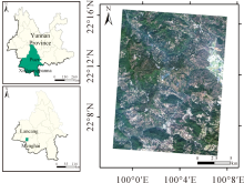
Fig.1
Location of the study area (GF-2 image on February 2, 2020)"

Tab.1
Satellite parameters"
| Satellite | Multispectral band | Resolution | Central wavelength /um |
|---|---|---|---|
| Sentinel-2 MultiSpectral Images (S2-MSI) | Band 1- Coastal aerosol | 60 | 0.443 |
| Band 2- Blue | 10 | 0.490 | |
| Band 3- Green | 10 | 0.560 | |
| Band 4- Red | 10 | 0.665 | |
| Band 5- Vegetation red edge | 20 | 0.705 | |
| Band 6- Vegetation red edge | 20 | 0.740 | |
| Band 7- Vegetation red edge | 20 | 0.783 | |
| Band 8- NIR | 10 | 0.842 | |
| Band 8A- Vegetation red edge | 20 | 0.865 | |
| Band 9- Water vapor | 60 | 0.945 | |
| Band 10- SWIR- Cirrus | 60 | 1.375 | |
| Band 11- SWIR | 20 | 1.610 | |
| Band 12- SWIR | 20 | 2.190 | |
| GF-2 Panchromatic and MultiSpectral (PMS) | Band 1- Blue | 4 | 0.45~0.52 |
| Band 2- Green | 4 | 0.52~0.59 | |
| Band 3- Red | 4 | 0.63~0.69 | |
| Band 4- NIR | 4 | 0.77~0.89 | |
| Panchromatic | 1 | 0.45~0.90 |
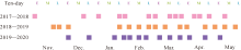
Fig.2
Acquisition dates of the multitemporal Sentinel-2 data used in this study. (“E” is the first 10-day period of a month; “M” is the middle 10-day period of a month; and “L” is the last 10-day period of a month)"


Fig.3
Methodological flowchart"
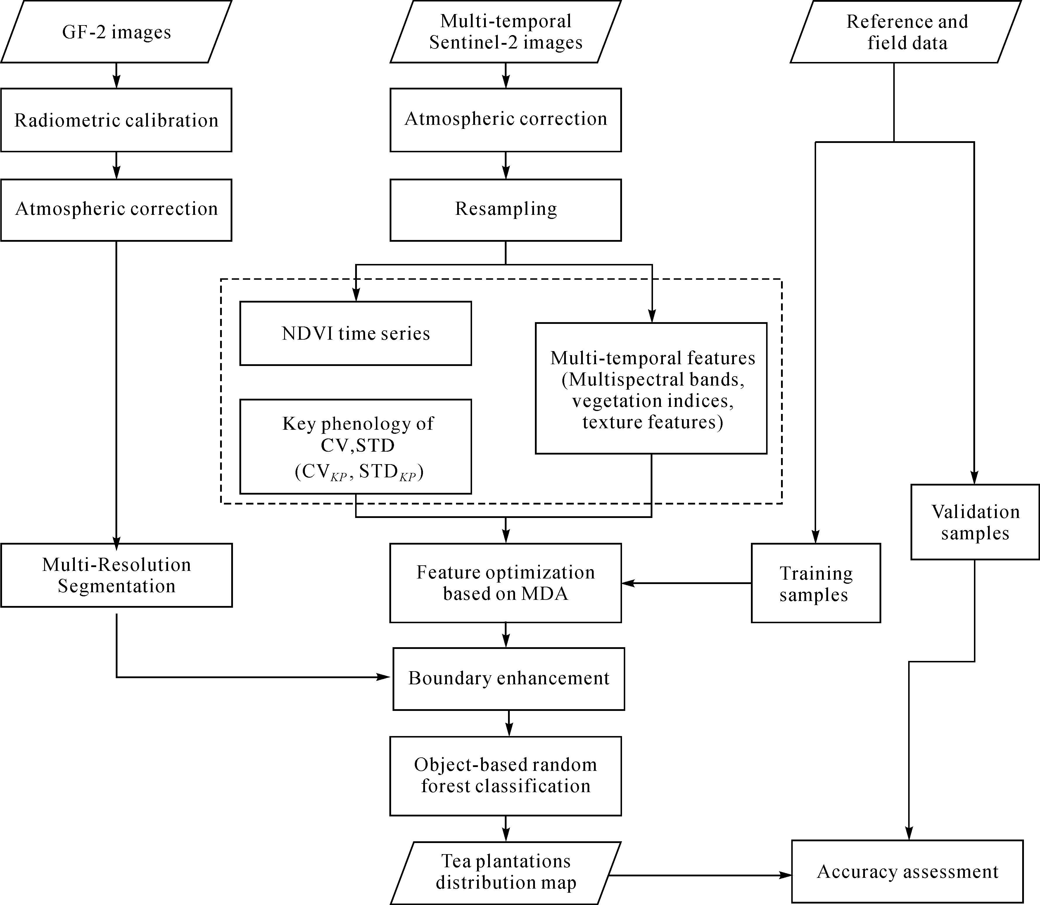
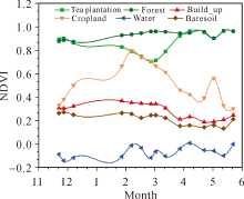
Fig.4
The NDVI time series variation diagram of various ground objects"

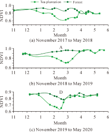
Fig.5
Changes in NDVI values of tea plantations and forests in three time periods"
Tab.2
Features extracted from multitemporal Sentinel-2 images"
| Feature | Description | Equation |
|---|---|---|
| Spectral bands | There are 12 spectral bands in the Sentinel-2 | B1, B2, B3, B4, B5, B6, B7, B8, B8A, B9, B11, B12 |
| Spectral indices | Normalized Difference Vegetation Index (NDVI) | NDVI= |
| Modified Normalized Difference Water Index (MNDWI) | MNDWI= | |
| S-2 Red-Edge Position index (S2REP) | S2REP=705+35×((((NIR+R)/2)-RE1)/(RE2-RE1))= 705+35×((((B7+B4)/2)-B5)/(B6-B5)) | |
| Brightness Index2 (BI2) | BI2= | |
| Texture features | Contrast | |
| Dissimilarity | ||
| Homogeneity | ||
| Angular Second Moment (ASM) | ||
| Energy | Energy= | |
| Maximum probability (Max) | Max=Maxi,j(Pi,j) | |
| Entropy | ||
| Mean | ||
| Variance | ||
| Correlation | ||
| NDVI time variation characteristics | σ | |
| CV | CV=σ/μ |
Fig.6
The result of the ESP2 calculation"
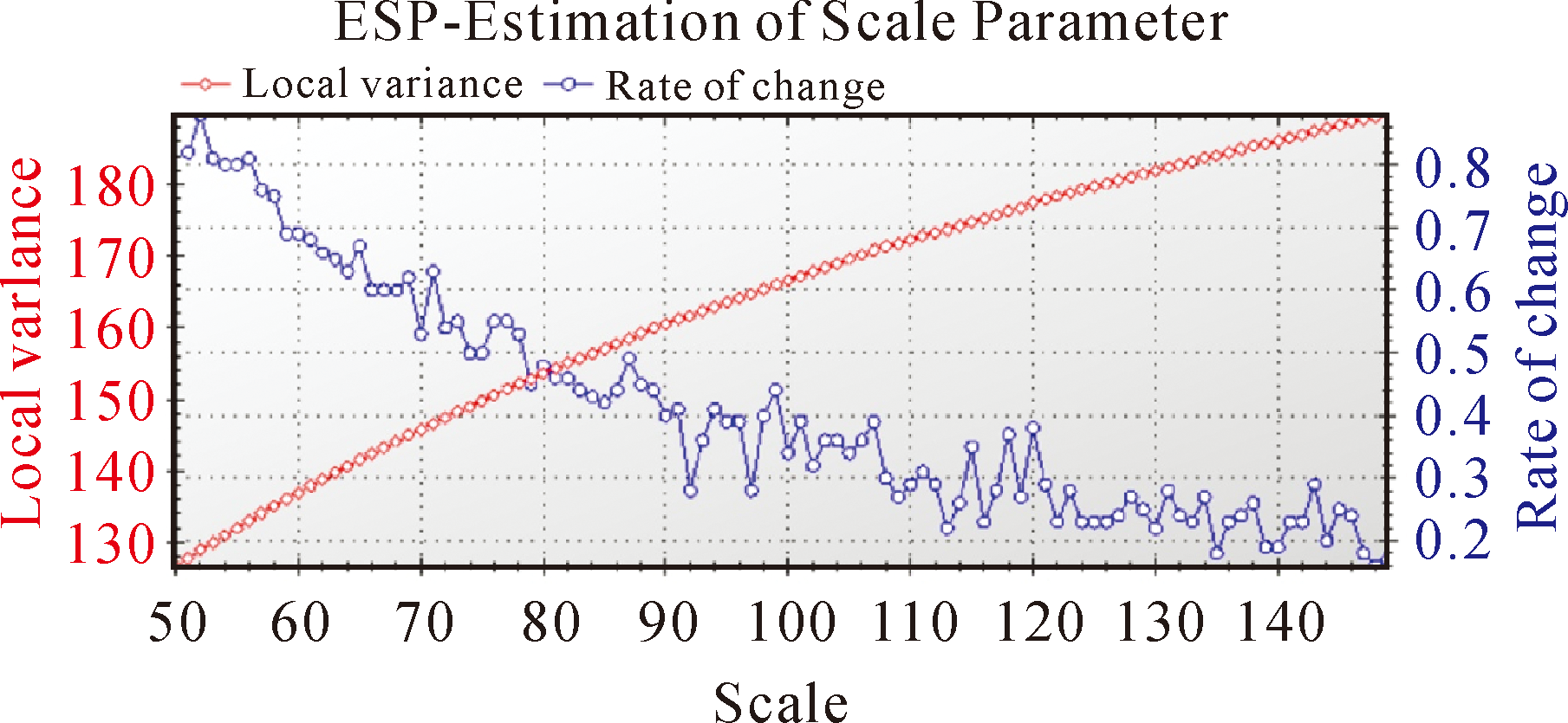
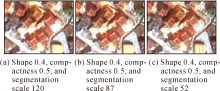
Fig.7
The segmentation effect at different scales"
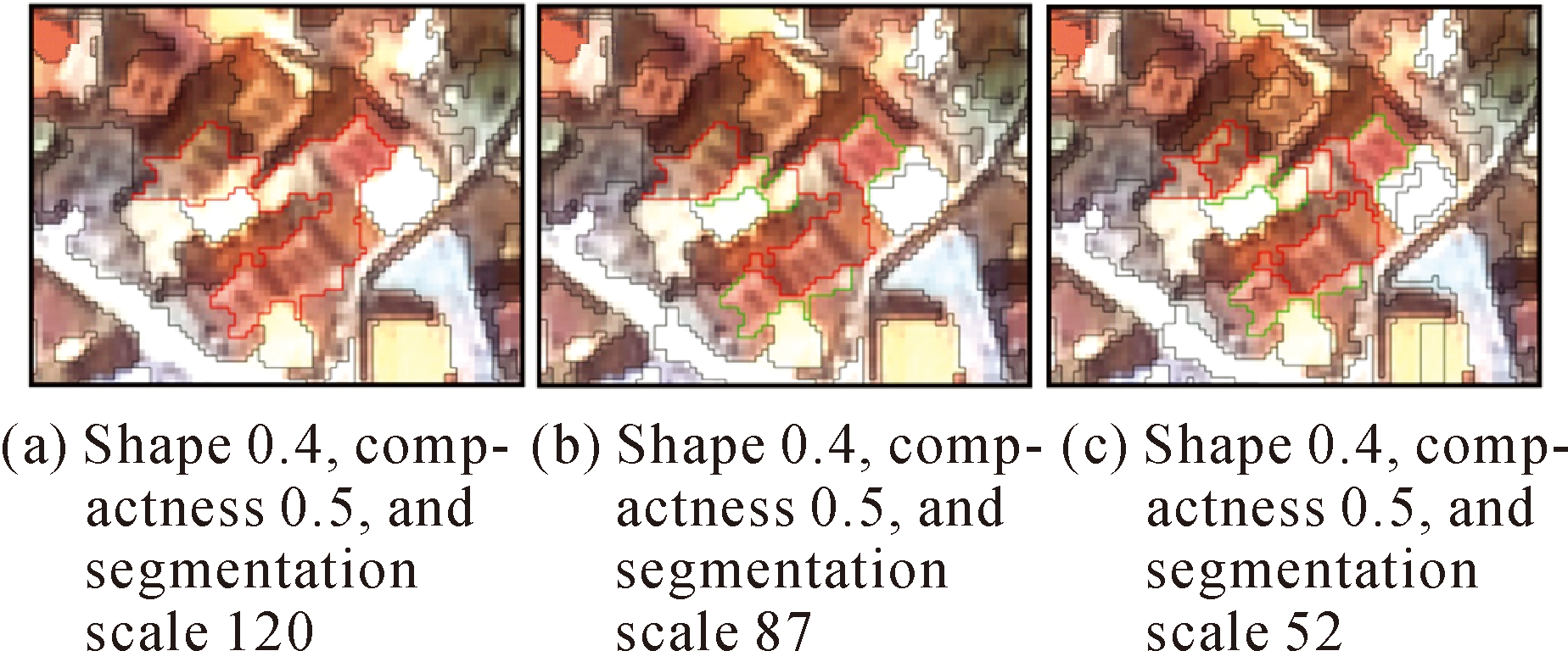

Fig.8
Variable importance based on MDA"
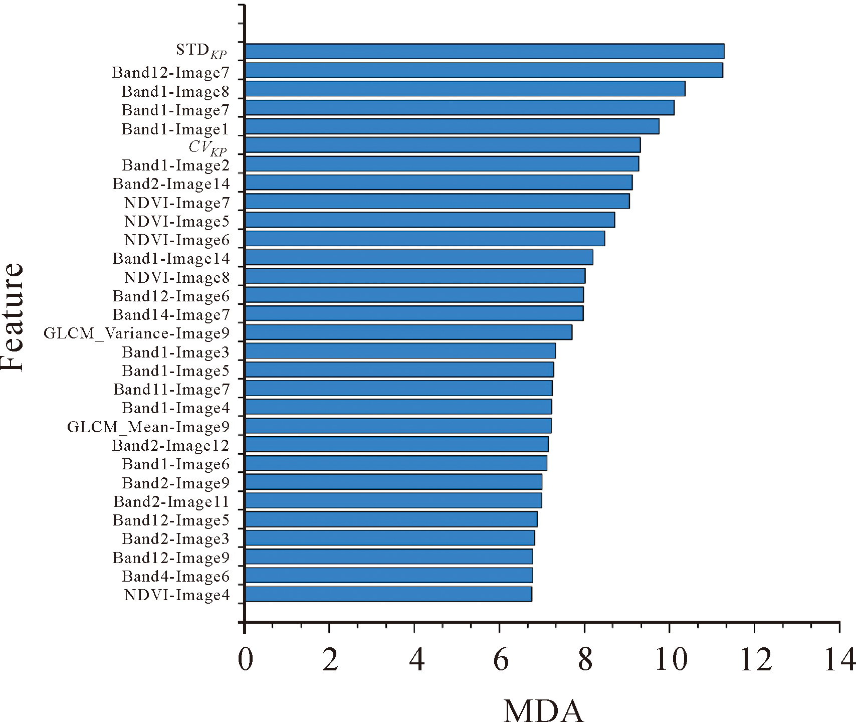
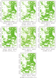
Fig.9
The classification results of the proposed method and six comparative experiments"

Tab.3
Classification accuracy of different methods"
| Classification method | Class | PA /(%) | UA /(%) | OA /(%) | Kappa coefficient |
|---|---|---|---|---|---|
| PBRF_S2 | Tea plantations | 82.35 | 97.11 | 88.93 | 0.78 |
| Others | 97.00 | 81.78 | |||
| PBRF_S2 (STDkp, CVkp) | Tea plantations | 83.54 | 97.44 | 89.84 | 0.80 |
| Others | 97.37 | 83.20 | |||
| OBRF_S2 | Tea plantations | 84.75 | 96.74 | 90.35 | 0.81 |
| Others | 96.74 | 84.76 | |||
| OBRF_S2 (STDkp, CVkp) | Tea plantations | 85.36 | 98.21 | 91.30 | 0.83 |
| Others | 98.20 | 85.25 | |||
| OBRF_GF2 | Tea plantations | 87.98 | 84.65 | 87.48 | 0.75 |
| Others | 87.08 | 89.95 | |||
| OBRF_S2_GF2 | Tea plantations | 92.14 | 95.42 | 94.08 | 0.88 |
| Others | 95.89 | 92.93 | |||
| OBRF_S2_GF2 (STDkp, CVkp) | Tea plantations | 93.32 | 96.99 | 95.38 | 0.91 |
| Others | 97.29 | 93.97 |

Fig.10
Tea plantation extraction results of three study typical regions ((a), (b), and (c)) in the study area using the proposed method and six comparative experiments"

| [1] |
ZHU Jun, PAN Ziwu, WANG Hang, et al. An improved multi-temporal and multi-feature tea plantation identification method using sentinel-2 imagery[J]. Sensors, 2019, 19(9): 2087.
doi: 10.3390/s19092087 |
| [2] |
HUANG Chengquan, GONG Weishu, PANG Yong. Remote sensing and forest carbon monitoring—a review of recent progress, challenges and opportunities[J]. Journal of Geodesy and Geoinformation Science, 2022, 5(2): 124-147. DOI: 10.11947/j.JGGS.2022.0212.
doi: 10.11947/j.JGGS.2022.0212 |
| [3] |
DONG Taifeng, LIU Jiangui, QIAN Budong, et al. Estimating crop biomass using leaf area index derived from Landsat 8 and Sentinel-2 data[J]. ISPRS Journal of Photogrammetry and Remote Sensing, 2020, 168: 236-250.
doi: 10.1016/j.isprsjprs.2020.08.003 |
| [4] |
COLOMBO R, BELLINGERI D, FASOLINI D, et al. Retrieval of leaf area index in different vegetation types using high resolution satellite data[J]. Remote Sensing of Environment, 2003, 86(1): 120-131.
doi: 10.1016/S0034-4257(03)00094-4 |
| [5] |
FAUZIANA F, DANOEDORO P, HERU MURTI S. Linear spectral mixture analysis of SPOT-7 for tea yield estimation in Pagilaran Estate, Batang Central Java[J]. IOP Conference Series: Earth and Environmental Science, 2016, 47: 012034.
doi: 10.1088/1755-1315/47/1/012034 |
| [6] |
YANG Chenghai, EVERITT J H, MURDEN D. Evaluating high resolution SPOT 5 satellite imagery for crop identification[J]. Computers and Electronics in Agriculture, 2011, 75(2): 347-354.
doi: 10.1016/j.compag.2010.12.012 |
| [7] |
ZHANG Chongyuan, MARZOUGUI A, SANKARAN S. High-resolution satellite imagery applications in crop phenotyping: an overview[J]. Computers and Electronics in Agriculture, 2020, 175: 105584.
doi: 10.1016/j.compag.2020.105584 |
| [8] |
LUCAS R, ROWLANDS A, BROWN A, et al. Rule-based classification of multi-temporal satellite imagery for habitat and agricultural land cover mapping[J]. ISPRS Journal of Photogrammetry and Remote Sensing, 2007, 62(3): 165-185.
doi: 10.1016/j.isprsjprs.2007.03.003 |
| [9] |
ZHANG Huanxue, LI Qiangzi, LIU Jiangui, et al. Object-based crop classification using multi-temporal SPOT-5 imagery and textural features with a Random Forest classifier[J]. Geocarto International, 2018, 33(10): 1017-1035.
doi: 10.1080/10106049.2017.1333533 |
| [10] |
XU Feng, LI Zhaofu, ZHANG Shuyu, et al. Mapping winter wheat with combinations of temporally aggregated Sentinel-2 and Landsat-8 data in Shandong Province, China[J]. Remote Sensing, 2020, 12(12): 2065.
doi: 10.3390/rs12122065 |
| [11] |
YAO Fangfang, WANG Jida, WANG Chao, et al. Constructing long-term high-frequency time series of global lake and reservoir areas using Landsat imagery[J]. Remote Sensing of Environment, 2019, 232: 111210.
doi: 10.1016/j.rse.2019.111210 |
| [12] |
VASILAKOS C, TSEKOURAS G E, KAVROUDAKIS D. LSTM-based prediction of mediterranean vegetation dynamics using NDVI time-series data[J]. Land, 2022, 11(6): 923.
doi: 10.3390/land11060923 |
| [13] |
CHEN Bangqian, XIAO Xiangming, LI Xiangping, et al. A mangrove forest map of China in 2015: analysis of time series Landsat 7/8 and Sentinel-1A imagery in Google Earth Engine cloud computing platform[J]. ISPRS Journal of Photogrammetry and Remote Sensing, 2017, 131: 104-120.
doi: 10.1016/j.isprsjprs.2017.07.011 |
| [14] |
ZHU Xiufang, XIAO Guofeng, ZHANG Dujuan, et al. Mapping abandoned farmland in China using time series MODIS NDVI[J]. Science of the Total Environment, 2021, 755: 142651.
doi: 10.1016/j.scitotenv.2020.142651 |
| [15] |
SUN Chao, FAGHERAZZI S, LIU Yongxue. Classification mapping of salt marsh vegetation by flexible monthly NDVI time-series using Landsat imagery[J]. Estuarine, Coastal and Shelf Science, 2018, 213: 61-80.
doi: 10.1016/j.ecss.2018.08.007 |
| [16] |
WANG Xinxin, XIAO Xiangming, ZOU Zhenhua, et al. Mapping coastal wetlands of China using time series Landsat images in 2018 and Google Earth Engine[J]. ISPRS Journal of Photogrammetry and Remote Sensing, 2020, 163: 312-326.
doi: 10.1016/j.isprsjprs.2020.03.014 |
| [17] |
YANG Yingying, WU Taixia, WANG Shudong, et al. Fractional evergreen forest cover mapping by MODIS time-series FEVC-CV methods at sub-pixel scales[J]. ISPRS Journal of Photogrammetry and Remote Sensing, 2020, 163: 272-283.
doi: 10.1016/j.isprsjprs.2020.03.012 |
| [18] |
HUANG Chong, ZHANG Chenchen, HE Yun, et al. Land cover mapping in cloud-prone tropical areas using Sentinel-2 data: integrating spectral features with NDVI temporal dynamics[J]. Remote Sensing, 2020, 12(7): 1163.
doi: 10.3390/rs12071163 |
| [19] |
CHAUHAN S, DARVISHZADEH R, LU Yi, et al. Understanding wheat lodging using multi-temporal Sentinel-1 and Sentinel-2 data[J]. Remote Sensing of Environment, 2020, 243: 111804.
doi: 10.1016/j.rse.2020.111804 |
| [20] |
ZHANG Weichun, LIU Hongbin, WU Wei, et al. Mapping rice paddy based on machine learning with sentinel-2 multi-temporal data: model comparison and transferability[J]. Remote Sensing, 2020, 12(10): 1620.
doi: 10.3390/rs12101620 |
| [21] |
BELGIU M, CSILLIK O. Sentinel-2 cropland mapping using pixel-based and object-based time-weighted dynamic time warping analysis[J]. Remote Sensing of Environment, 2018, 204: 509-523.
doi: 10.1016/j.rse.2017.10.005 |
| [22] |
BLASCHKE T. Object based image analysis for remote sensing[J]. ISPRS Journal of Photogrammetry and Remote Sensing, 2010, 65(1): 2-16.
doi: 10.1016/j.isprsjprs.2009.06.004 |
| [23] | CHEN Y, TIAN S. Comparison of pixel- and object-based image analysis for tea plantation mapping using hyperspectral Gaofen-5 and synthetic aperture radar data[J]. Journal of Applied Remote Sensing, 2020, 14(4): 1-21. |
| [24] |
CAI Y, LI X, ZHANG M, et al. Mapping wetland using the object-based stacked generalization method based on multi-temporal optical and SAR data[J]. International Journal of Applied Earth Observation and Geoinformation, 2020, 92(5): 102164.
doi: 10.1016/j.jag.2020.102164 |
| [25] |
BLASCHKE T, FEIZIZADEH B, HÖLBLING D. Object-based image analysis and digital terrain analysis for locating landslides in the Urmia Lake Basin, Iran[J]. IEEE Journal of Selected Topics in Applied Earth Observations and Remote Sensing, 2014, 7(12): 4806-4817.
doi: 10.1109/JSTARS.4609443 |
| [26] |
BEKTAS BALCIK F, SENEL G, GOKSEL C. Object-based classification of greenhouses using sentinel-2 MSI and SPOT-7 images: a case study from anamur (Mersin), Turkey[J]. IEEE Journal of Selected Topics in Applied Earth Observations and Remote Sensing, 2020, 13: 2769-2777.
doi: 10.1109/JSTARS.4609443 |
| [27] |
TANG Zixia, LI Mengmeng, WANG Xiaoqin. Mapping tea plantations from VHR images using OBIA and convolutional neural networks[J]. Remote Sensing, 2020, 12(18): 2935.
doi: 10.3390/rs12182935 |
| [28] |
BELGIU M, DRǍGUŢ L. Random forest in remote sensing: a review of applications and future directions[J]. ISPRS Journal of Photogrammetry and Remote Sensing, 2016, 114: 24-31.
doi: 10.1016/j.isprsjprs.2016.01.011 |
| [29] |
MAHDIANPARI M, SALEHI B, MOHAMMADIMANESH F, et al. Random forest wetland classification using ALOS-2 L-band, RADARSAT-2 C-band, and TerraSAR-X imagery[J]. ISPRS Journal of Photogrammetry and Remote Sensing, 2017, 130: 13-31.
doi: 10.1016/j.isprsjprs.2017.05.010 |
| [30] |
STUMPF A, KERLE N. Object-oriented mapping of landslides using random forests[J]. Remote Sensing of Environment, 2011, 115(10): 2564-2577.
doi: 10.1016/j.rse.2011.05.013 |
| [31] |
PUISSANT A, ROUGIER S, STUMPF A. Object-oriented mapping of urban trees using random forest classifiers[J]. International Journal of Applied Earth Observation and Geoinformation, 2014, 26: 235-245.
doi: 10.1016/j.jag.2013.07.002 |
| [32] |
CAI Yaotong, LIN Hui, ZHANG Meng. Mapping paddy rice by the object-based random forest method using time series Sentinel-1/Sentinel-2 data[J]. Advances in Space Research, 2019, 64(11): 2233-2244.
doi: 10.1016/j.asr.2019.08.042 |
| [33] |
HUNG P Y. Tea forest in the making: tea production and the ambiguity of modernity on China’s southwest frontier[J]. Geoforum, 2013, 47: 178-188.
doi: 10.1016/j.geoforum.2013.01.007 |
| [34] | LI Rui. The value of Asian tea culture from the perspective of integration of tea and tourism industry—a case study of Jingmai Mountain, Yunnan[C]//Proceedings of the 2nd Asia-Pacific Social Science and Modern Education Conference(SSME 2019). Shanghai:[s.n.], 2019. |
| [35] |
WANG Qunming, ATKINSON P M. Spatio-temporal fusion for daily Sentinel-2 images[J]. Remote Sensing of Environment, 2018, 204: 31-42.
doi: 10.1016/j.rse.2017.10.046 |
| [36] |
WANG Mi, ZHANG Zhiqi, DONG Zhipeng, et al. Stream-computing of high accuracy on-board real-time cloud detection for high resolution optical satellite imagery[J]. Journal of Geodesy and Geoinformation Science, 2019, 2(2): 50-59. DOI: 10.11947/j.JGGS.2019.0206.
doi: 10.11947/j.JGGS.2019.0206 |
| [37] | ROUSE JR J W, HAAS R H, SCHELL J A, et al. Monitoring vegetation systems in the great plains with ERTS[R]. Washington, DC: NASA, 1974. |
| [38] |
XU Hanqiu. Modification of Normalised Difference Water Index (NDWI) to enhance open water features in remotely sensed imagery[J]. International Journal of Remote Sensing, 2006, 27(14): 3025-3033.
doi: 10.1080/01431160600589179 |
| [39] | ESCADAFAL R. Remote sensing of arid soil surface color with Landsat thematic mapper[J]. Advances in Space Research, 1989, 9(1): 159-163. |
| [40] | GUYOT G, BARET F. Utilisation de la haute resolution spectrale pour suivre l’etat des couverts vegetaux[C]//Proceedings of the 4th International Colloquium “Spectral Signatures of Objects in Remote Sensing. Paris: ESA, 1988: 279-286. |
| [41] |
LUO Hongxia, DAI Shengpei, LI Maofen, et al. Comparison of machine learning algorithms for mapping mango plantations based on Gaofen-1 imagery[J]. Journal of Integrative Agriculture, 2020, 19(11): 2815-2828.
doi: 10.1016/S2095-3119(20)63208-7 |
| [42] |
YANG Zhi, SHAO Yun, LI Kun, et al. An improved scheme for rice phenology estimation based on time-series multispectral HJ-1A/B and polarimetric RADARSAT-2 data[J]. Remote Sensing of Environment, 2017, 195: 184-201.
doi: 10.1016/j.rse.2017.04.016 |
| [43] |
BOONPRONG S, CAO Chunxiang, CHEN Wei, et al. Random forest variable importance spectral indices scheme for burnt forest recovery monitoring-multilevel RF-VIMP[J]. Remote Sensing, 2018, 10(6): 807.
doi: 10.3390/rs10060807 |
| [44] |
BREIMAN L. Random forests[J]. Machine Learning, 2001, 45(1): 5-32.
doi: 10.1023/A:1010933404324 |
| [45] |
KARLSON M, GÅLFALK M, CRILL P, et al. Delineating northern peatlands using Sentinel-1 time series and terrain indices from local and regional digital elevation models[J]. Remote Sensing of Environment, 2019, 231: 111252.
doi: 10.1016/j.rse.2019.111252 |
| [46] |
NGUYEN H T T, DOAN T M, TOMPPO E, et al. Land use/land cover mapping using multitemporal sentinel-2 imagery and four classification methods—a case study from Dak Nong, Vietnam[J]. Remote Sensing, 2020, 12(9): 1367.
doi: 10.3390/rs12091367 |
| [47] |
CHEN Yunhao, CHEN Qiang, JING Changfeng. Multi-resolution segmentation parameters optimization and evaluation for VHR remote sensing image based on mean NSQI and discrepancy measure[J]. Journal of Spatial Science, 2021, 66(2): 253-278.
doi: 10.1080/14498596.2019.1615011 |
| [48] |
MOHAMMADIMANESH F, SALEHI B, MAHDIANPARI M, et al. Multi-temporal, multi-frequency, and multi-polarization coherence and SAR backscatter analysis of wetlands[J]. ISPRS Journal of Photogrammetry and Remote Sensing, 2018, 142: 78-93.
doi: 10.1016/j.isprsjprs.2018.05.009 |
| [49] |
MOHAMMADIMANESH F, SALEHI B, MAHDIANPARI M, et al. An efficient feature optimization for wetland mapping by synergistic use of sar intensity, interferometry, and polarimetry data[J]. International Journal of Applied Earth Observation and Geoinformation, 2018, 73: 450-462.
doi: 10.1016/j.jag.2018.06.005 |
| [50] |
MA Lei, LI Manchun, MA Xiaoxue, et al. A review of supervised object-based land-cover image classification[J]. ISPRS Journal of Photogrammetry and Remote Sensing, 2017, 130: 277-293.
doi: 10.1016/j.isprsjprs.2017.06.001 |
| [51] |
DRǍGUŢ L, TIEDE D, LEVICK S R. ESP: a tool to estimate scale parameter for multiresolution image segmentation of remotely sensed data[J]. International Journal of Geographical Information Science, 2010, 24(6): 859-871.
doi: 10.1080/13658810903174803 |
| [52] |
DRǍGUŢ L, CSILLIK O, EISANK C, et al. Automated parameterisation for multi-scale image segmentation on multiple layers[J]. ISPRS Journal of Photogrammetry and Remote Sensing, 2014, 88: 119-127.
doi: 10.1016/j.isprsjprs.2013.11.018 |
| [53] |
HAY G J, BLASCHKE T, MARCEAU D J, et al. A comparison of three image-object methods for the multiscale analysis of landscape structure[J]. ISPRS Journal of Photogrammetry and Remote Sensing, 2003, 57(5-6): 327-345.
doi: 10.1016/S0924-2716(02)00162-4 |
| [54] |
MARTHA T R, KERLE N, VAN WESTEN C J, et al. Segment optimization and data-driven thresholding for knowledge-based landslide detection by object-based image analysis[J]. IEEE Transactions on Geoscience and Remote Sensing, 2011, 49(12): 4928-4943.
doi: 10.1109/TGRS.2011.2151866 |
| [55] |
PAL M. Random forest classifier for remote sensing classification[J]. International Journal of Remote Sensing, 2005, 26(1): 217-222.
doi: 10.1080/01431160412331269698 |
| [56] |
ZHAO Yi, JIANG Mi, MA Zhangfeng. Integration of SAR polarimetric features and multi-spectral data for object-based land cover classification[J]. Journal of Geodesy and Geoinformation Science, 2019, 2(4): 64-72. DOI: 10.11947/j.JGGS.2019.0407.
doi: 10.11947/j.JGGS.2019.0407 |
| [57] |
STEHMAN S V, FOODY G M. Key issues in rigorous accuracy assessment of land cover products[J]. Remote Sensing of Environment, 2019, 231: 111199.
doi: 10.1016/j.rse.2019.05.018 |
| [1] | Julien BRIANT,Huber CLAIRE,Studer MATHIAS,Lei CAO,Kunpeng YI,Yésou HERVÉ. Water Resource Monitoring Exploiting Sentinel-2 Satellite and Sentinel-2 Satellite Like Time Series; Application in Yangtze River Water Bodies [J]. Journal of Geodesy and Geoinformation Science, 2020, 3(4): 41-49. |
| Viewed | ||||||
|
Full text |
|
|||||
|
Abstract |
|
|||||