
Journal of Geodesy and Geoinformation Science ›› 2022, Vol. 5 ›› Issue (2): 75-84.doi: 10.11947/j.JGGS.2022.0208
• Special Issue • Previous Articles Next Articles
Kseniia SERGEEVA1,2( ),Hui LIN1,2()
Received:2021-10-03
Accepted:2022-03-21
Online:2022-06-20
Published:2022-07-22
Contact:
Hui LIN
E-mail:xsergeeva90@gmail.com;huilin@cuhk.edu.hk
About author:Kseniia SERGEEVA (1990—), female, majors in application of remote sensing tools for geographic solutions. E-mail: Supported by:Kseniia SERGEEVA,Hui LIN. The Extent and Effectiveness of Protected Areas in the Russian Federation[J]. Journal of Geodesy and Geoinformation Science, 2022, 5(2): 75-84.
Add to citation manager EndNote|Reference Manager|ProCite|BibTeX|RefWorks

Fig.1
Significance dynamics for SPNAs in the Russian Federation throughout 2014—2019"

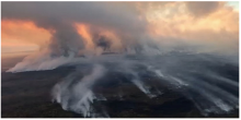
Fig.2
Areal footage of massive forest fires in Olekminsky Nature Reserve, Yakutia, June 2021"

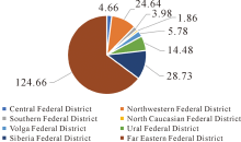
Fig.3
Total area of specially protected natural areas by territorial entities of the Russian Federation for 2019"


Fig.4
Total area of specially protected natural areas by significance in the Russian federation for 2019"
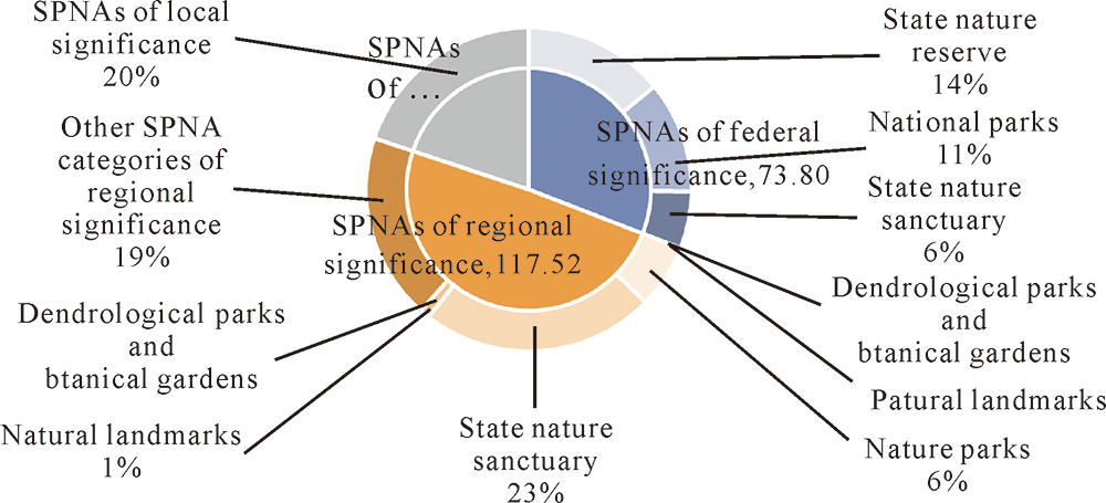
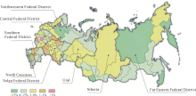
Fig.5
Visual scheme of relative area of SPNAs in the Russian Federation[15]"
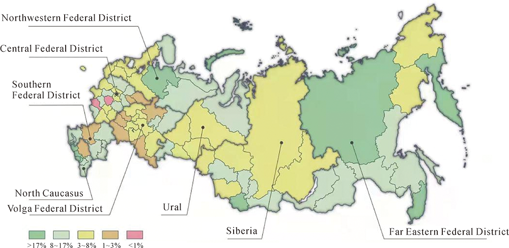

Fig.6
Number of visitors of SPNAs in the Russian Federation"
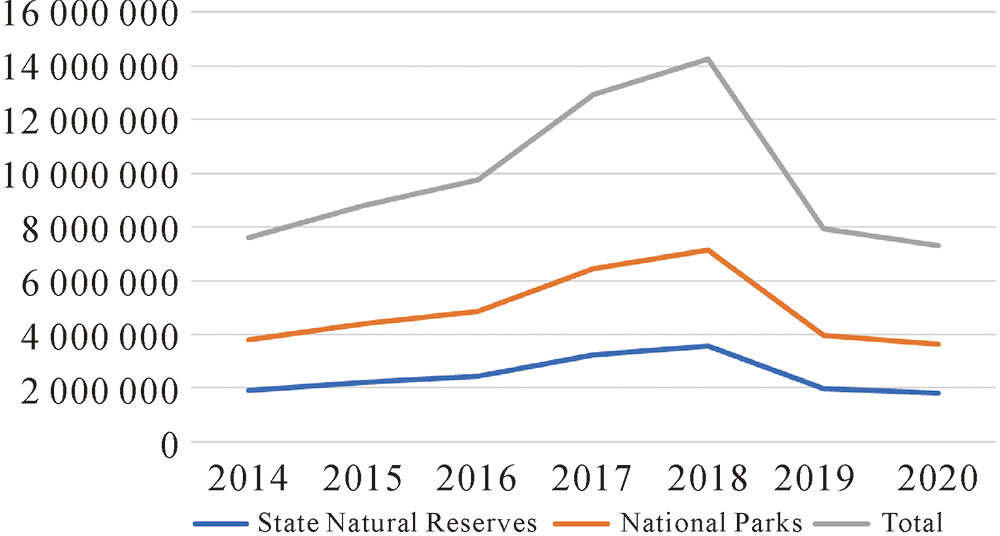
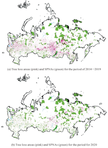
Fig.7
Visual scheme of tree loss in SPNAs in the Russian Federation[16⇓-18]"

| [1] | IVANOV A N, CHIZHOVA V P. Protected natural areas studyguide[M]. 2nd ed.. Department of Geography, Moscow State University: [s.n.], 2009. |
| [2] | ZIMIN A A, YUSHKOV S V. Monuments of Russian law: Kievan state in Ⅹ-Ⅻ centuries[M]. Moscow, Gosurizdat: [s.n.], 1952. |
| [3] | DEMCHENKO O N. The syncretism of the indigenous ethnic cults of the far north[C]// Proceedings of the Traditional Culture of Nomadic Peoples in the System of Art Education. Yakutsk: [s.n.], 2014. |
| [4] | GAVRILOV D A, NAGOVITSYN A E. Gods of the Slavs.paganism. tradition[M]. Moscow: Refl-Book, 2002. |
| [5] |
MÜLLER M. From sacred cow to cash cow: The shifting political ecologies of protected areas in Russia[J]. Zeitschrift für Wirtschaftsgeographie, 2014, 58(2-3): 127-143.
doi: 10.1515/zfw.2014.0009 |
| [6] |
SLEPNEV M, MARSHALKOVICH A, PAPUSH P. Creating protected areas in the urban environment, corresponding to the “smart city” formation concept. The way to sustainable development of urban ecosystems[J]. IOP Conference Series: Materials Science and Engineering, 2018, 365(2): 022034.
doi: 10.1088/1757-899X/365/2/022034 |
| [7] | YORKE O. Deforestation in Russia: depleting the lungs of theworld[EB/OL]. [2021-07-08]. https://earth.org/deforestation-in-russia . |
| [8] | Federal Law Dated 14 March 1995 No.33-FZ. On especially protected natural territories[DB/OL]. [2021-07-01]. https://www.global-regulation.com/translation/russia/2941292/on-especially-protected-natural-territories.html . |
| [9] | ROSSTAT: Federal State Statistics Service. About SDGs[DB/OL]. [2021-07-01]. https://eng.rosstat.gov.ru/sdg . |
| [10] | Decree of the President of the Russian Federation of April 19, 2017 No. 176. On the strategy of ecological safety of the Russian Federation for the period up to 2025[DB/OL]. [2021-07-01]. http://kremlin.ru/acts/bank/41879 . |
| [11] | ROSSTAT: Federal State Statistics Service. Total area of SPNAs[DB/OL]. [2021-07-01]. https://rosstat.gov.ru/storage/mediabank/qlhISygW/os_oxr_ter.xlsx . |
| [12] |
GATTI R C, VELICHEVSKAYA A, DUDKO A, et al. The smoke screen of Russian protected areas[J]. Science of the Total Environment, 2021, 785: 147372.
doi: 10.1016/j.scitotenv.2021.147372 |
| [13] | HOCKINGS M, STOLTON S, LEVERINGTON F, et al. Evaluating effectiveness: a framework for assessing management effectiveness of protected areas[EB/OL]. [2021-07-08]. https://portals.iucn.org/library/sites/library/files/documents/PAG-014.pdf . |
| [14] | DAVEY A G. National system planning for protected areas[EB/OL]. [2021-07-02]. https://portals.iucn.org/library/sites/library/files/documents/PAG-001.pdf . |
| [15] | ROSSTAT: Federal State Statistics Service. Scanned documents and reports on SPNAs from each territorial entity of the Russian Federation[DB/OL]. [2021-07-01]. https://rosstat.gov.ru/monitoring?document=96634 . |
| [16] | Ministry of Natural Resources and Environment of the Russian Federation. Russia’s specially protected natural areas and sites (SPNA)[DB/OL]. [2021-07-01]. https://www.mnr.gov.ru/activity/oopt . |
| [17] | UNEP-WCMC. Protected area profile for Russian Federation from the world database of protected areas[DB/OL]. [2021-08-20]. https://www.protectedplanet.net . |
| [18] |
HANSEN M C, POTAPOV P V, MOORE R, et al. High-resolution global maps of 21st-century forest cover change[J]. Science, 2013, 342(6160): 850-853.
doi: 10.1126/science.1244693 |
| [19] | Decree of the President of the Russian Federation Dated 13 May 2000 No.849. On the Plenipotentiary representative of the president of the Russian federation in the federal district[DB/OL]. [2021-07-01]. http://www.kremlin.ru/acts/bank/15492 . |
| [20] | Order of the Government of the Russian Federation of 22.12.2011 No.2322-p. On approval of the concept of development of specially protected natural areas of federal importance for the period until 2020” (together with “action plan for implementation of the concept of development of specially protected natural areas of federal importance for the period until 2020”)[DB/OL]. [2021-07-01]. http://www.consultant.ru/document/cons_doc_LAW_124870 . |
| [21] |
EAGLES P F J, CASCAGNETTE J W. Canadian ecotourists. Who are they?[J]. Tourism Recreation Research, 1995, 20(1): 22-28. DOI: 10.1080/02508281.1995.11014729.
doi: 10.1080/02508281.1995.11014729 |
| [22] | HIGGINS B R. Decolonizing ecotourism in North America[EB/OL]. [2021-07-02]. https://www.researchgate.net/publication/336535762_Decolonizing_Ecotourism_in_North_America . |
| [23] |
NEBESNAYA A, GARSHINA A, ORUSOV A. The development of ecotourism in China[J]. Actual Directions of Scientific Researches of the XXI Century Theory and Practice, 2015, 3(4): 14-18. DOI: 10.12737/14206.
doi: 10.12737/14206 |
| [24] |
YE Wen, XUE Ximing. The differences in ecotourism between China and the West[J]. Current Issues in Tourism, 2008, 11(6): 567-586. DOI: 10.1080/13683500802475927.
doi: 10.1080/13683500802475927 |
| [25] | SUNRui. On stakeholders of ecotourism: with China as an example[J]. China Population, Resources and Environment, 2005, 15(1): 36-41. |
| [26] |
LI Yanpeng, ZHANG Lixiang, GAO Ying, et al. Ecotourism in China, misuse or genuine development? An analysis based on map browser results[J]. Sustainability, 2019, 11(18): 4997. DOI: 10.3390/su11184997.
doi: 10.3390/su11184997 |
| [27] | GEORGE P R, WELLINGTON B V. Ecotourism and conservation-review[M]// SAILAJAV. Biodiversity and Ecotourism. Chennai: Jupitor Publications, 2021: 39-42. |
| [28] |
JENKINS J, WEARING S. Ecotourism and protected areas inAustralia[M]// FENNELLD A, DOWLINGR K. Ecotourism Policy and Planning. Cambridge: CABI Pub, 2003. DOI: 10.1079/9780851996097.0205.
doi: 10.1079/9780851996097.0205 |
| [29] |
HIGHAM J E S, CARR A. Profiling tourists to ecotourism operations[J]. Annals of Tourism Research, 2002, 29(4): 1168-1171. DOI: 10.1016/S0160-7383(02)00037-3.
doi: 10.1016/S0160-7383(02)00037-3 |
| [30] |
JOHNSON A F, GONZALES C, TOWNSEL A, et al. Marine ecotourism in the gulf of California and the Baja California peninsula: research trends and information gaps[J]. Scientia Marina, 2019, 83(2): 177. DOI: 10.3989/scimar.04880.14A.
doi: 10.3989/scimar.04880.14A |
| [31] | MARIAPAN M, AI LIN E L, BIDIN S, et al. Ecotourism in Malaysia: current scenario[C]//Proceedings of the 3rd International Conference on Adventure and Ecotourism. Puchong, Selangor, Malaysia: [s.n.], 2019. |
| [32] | Australian Government: Department of Agriculture, Water and the Environment. The limits of acceptable change[DB/OL]. [2021-07-07]. https://www.environment.gov.au/water/wetlands/publications/factsheet-limits-acceptable-change . |
| [33] | World Travel & Tourism Council. Global wildlife tourism generates five times more revenue than illegal wildlife trade annually[DB/OL]. [2021-07-07]. https://wttc.org/News-Article/Global-wildlife-tourism-generates-five-times-more-revenue-than-illegal-wildlife-trade-annually . |
| [34] |
BALMFORD A, GREEN J M H, ANDERSON M, et al. Walk on the wild side: estimating the global magnitude of visits to protected areas[J]. PLoS Biology, 2015, 13(2): e1002074. DOI: 10.1371/journal.pbio.1002074.
doi: 10.1371/journal.pbio.1002074 |
| [1] | Yu Ning Hazel ANG,; Kai CAO. GIS Based FLMP Solving in Densely Populated City Areas: a Case Study in Singapore [J]. Journal of Geodesy and Geoinformation Science, 2022, 5(2): 111-123. |
| [2] | Yusheng XU,Rong HUANG,Xiaohua TONG,Uwe STILLA. Exploiting Robust Estimators in Phase Correlation of 3D Point Clouds for 6 DoF Pose Estimation [J]. Journal of Geodesy and Geoinformation Science, 2021, 4(3): 72-90. |
| [3] | Hartmut BOESCH,Yi LIU,Paul I PALMER,Johanna TAMMINEN,Jasdeep S ANAND,Zhaonan CAI,Ke CHE,Huilin CHEN,Xi CHEN,Liang FENG,Janne HAKKARAINEN,Pauli HEIKKINEN,Nikoleta KALAITZI,Rigel KIVI,Robert PARKER,Peter SOMKUTI,Jing WANG,Alex WEBB,Dongxu YANG,Lu YAO,You YI. Monitoring Greenhouses Gases over China Using Space-Based Observations [J]. Journal of Geodesy and Geoinformation Science, 2020, 3(4): 14-24. |
| [4] | Zongcheng ZUO, Wen ZHANG, Dongying ZHANG. A Remote Sensing Image Semantic Segmentation Method by Combining Deformable Convolution with Conditional Random Fields [J]. Journal of Geodesy and Geoinformation Science, 2020, 3(3): 39-49. |
| [5] | Hao HE,Shuyang WANG,Shicheng WANG,Dongfang YANG,Xing LIU. A Road Extraction Method for Remote Sensing Image Based on Encoder-Decoder Network [J]. Journal of Geodesy and Geoinformation Science, 2020, 3(2): 16-25. |
| [6] | Lihua ZHANG,Lulu TANG,Shuaidong JIA,Zeyuan DAI. A Collaborative Simplification Method for Multiple Coastlines Based on the Hierarchical Triangulation Network Partition [J]. Journal of Geodesy and Geoinformation Science, 2020, 3(2): 93-104. |
| [7] | Wenjie LIN,Yu LI,Quanhua ZHAO. High-resolution Remote Sensing Image Segmentation Using Minimum Spanning Tree Tessellation and RHMRF-FCM Algorithm [J]. Journal of Geodesy and Geoinformation Science, 2020, 3(1): 52-63. |
| [8] | Yuchao DAI,Jing ZHANG,Mingyi HE,Fatih PORIKLI,Bowen LIU. Salient Object Detection from Multi-spectral Remote Sensing Images with Deep Residual Network [J]. Journal of Geodesy and Geoinformation Science, 2019, 2(2): 101-110. |
| [9] | Yun ZHANG. Smart Photogrammetric and Remote Sensing Image Processing for Very High Resolution Optical Images— Examples from the CRC-AGIP Lab at UNB [J]. Journal of Geodesy and Geoinformation Science, 2019, 2(2): 17-26. |
| Viewed | ||||||
|
Full text |
|
|||||
|
Abstract |
|
|||||