
Journal of Geodesy and Geoinformation Science ›› 2024, Vol. 7 ›› Issue (3): 1-23.doi: 10.11947/j.JGGS.2024.0301
ZHANG Xinchang1,2( ), SHI Qian3, SUN Ying3, HUANG Jianfeng4, HE Da3
Published:2024-09-25
Online:2024-09-23
About author:ZHANG Xinchang, professor, PhD supervisor, majors in urban geographic information system.E-mail zhangxc@gzhu.edu.cn.
Supported by:ZHANG Xinchang, SHI Qian, SUN Ying, HUANG Jianfeng, HE Da. The Review of Land Use/Land Cover Mapping AI Methodology and Application in the Era of Remote Sensing Big Data[J]. Journal of Geodesy and Geoinformation Science, 2024, 7(3): 1-23.
Add to citation manager EndNote|Reference Manager|ProCite|BibTeX|RefWorks
Table 1
Comparison of the land use and land cover in terms of definition, methodology and application"
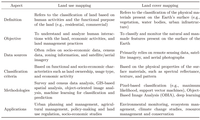 |
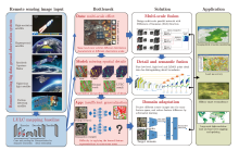
Figure 1
Overview of remote sensing big data in land use/land cover mapping research field, including bottleneck, methodology and application"


Figure 2
General structure of semantic segmentation for LULC mapping, and the three geographical problems in this process"
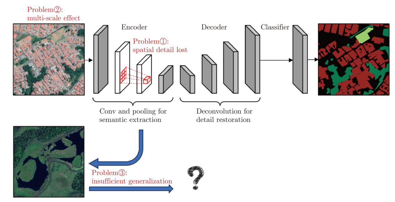
Table 2
The ResNet101 architecture for feature extraction in encoder"
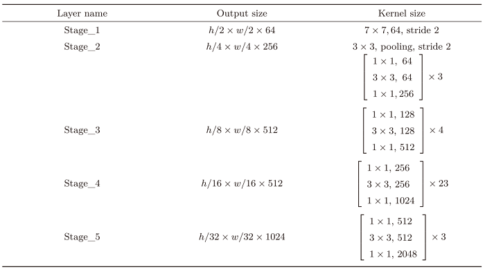 |
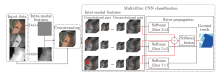
Figure 3
Flowchart of the multi-scale filter parallel semantic segmentation model"

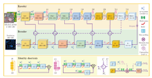
Figure 4
The framework of a multi-level feature fusion gated residual refinement semantic segmentation model"
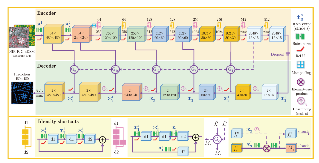
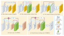
Figure 5
Schematic diagram of the gated feature labeling unit"

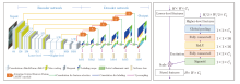
Figure 6
Flowchart of visual attention-guided refinement for semantic segmentation model"

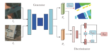
Figure 7
Flowchart of adversarial discriminative domain adaptation semantic segmentation model constrained by Kullback-Leibler divergence"

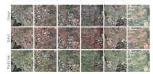
Figure 8
The result of the parcel-level cropland extraction"
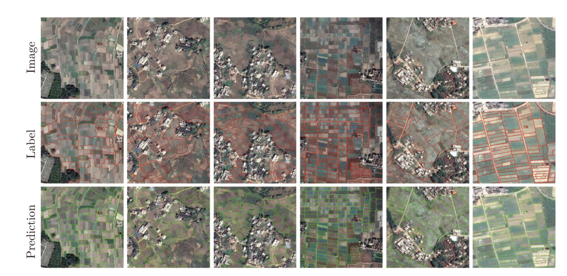
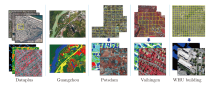
Figure 9
The public building extraction dataset"
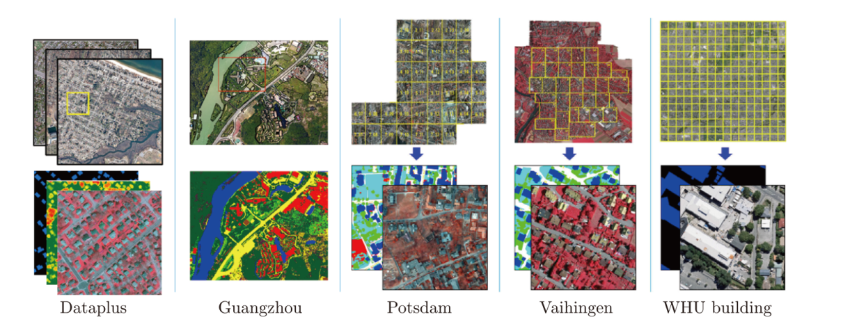

Figure 10
The building extraction result of each algorithm"

Table 3
The basic information of the public dataset for building extraction"
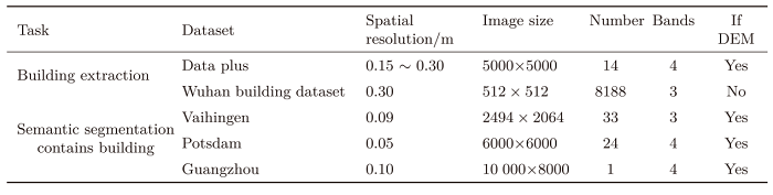 |
Table 4
Quantitative evaluation of each compared network on building extraction dataset"
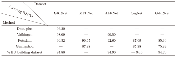 |

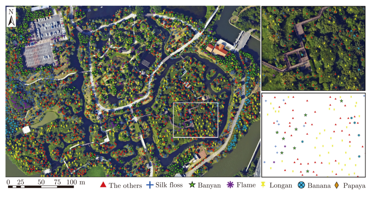
Figure 11
The result of tree extraction and inter-species classification"
| [1] |
OVERPECK J T, MEEHL G A, BONY S, et al. Climate data challenges in the 21st century[J]. Science, 2011, 331(6018): 700-702.
doi: 10.1126/science.1197869 pmid: 21311006 |
| [2] | YANG Jun, GONG Peng, FU Rong, et al. The role of satellite remote sensing in climate change studies[J]. Nature Climate Change, 2013, 3(10): 875-883. |
| [3] |
GONG Peng, LIU Han, ZHANG Meinan, et al. Stable classification with limited sample: transferring a 30-m resolution sample set collected in 2015 to mapping 10-m resolution global land cover in 2017[J]. Science Bulletin, 2019, 64(6): 370-373.
doi: 10.1016/j.scib.2019.03.002 pmid: 36659725 |
| [4] | KARRA K, KONTGIS C, STATMAN-WEIL Z, et al. Global land use / land cover with Sentinel 2 and deep learning[C]// Proceedings of 2021 IEEE International Geoscience and Remote Sensing Symposium IGARSS. Brussels: IEEE, 2021: 4704-4707. |
| [5] | ZANAGA D, VAN DE KERCHOVE R, DAEMS D, et al. ESA WorldCover 10 m 2021 v200[EB/OL]. [2024-06-29]. https://developers.google.com/earth/engine/datasets/catalog/ESA_WorldCover_v200. |
| [6] | YANG J, HUANG X. The 30 m annual land cover dataset and its dynamics in China from 1990 to 2019[J]. Earth System Science Data, 2021, 13(8): 3907-3925. |
| [7] | ZHANG Ce, SARGENT I, PAN Xin, et al. An object-based convolutional neural network for urban land use classification[J]. Remote Sensing of Environment, 2018, 216: 57-70. |
| [8] | VOLPI M, TUIA D. Dense semantic labeling of subdecimeter resolution images with convolutional neural networks[J]. IEEE Transactions on Geoscience and Remote Sensing, 2017, 55(2): 881-893. |
| [9] | DENG Zhipeng, SUN Hao, ZHOU Shilin, et al. Multi-scale object detection in remote sensing imagery with convolutional neural networks[J]. ISPRS Journal of Photogrammetry and Remote Sensing, 2018, 145: 3-22. |
| [10] | BLASCHKE T. Object based image analysis for remote sensing[J]. ISPRS Journal of Photogrammetry and Remote Sensing, 2010, 65(1): 2-16. |
| [11] | DURO D C, FRANKLIN S E, DUBÉ M G. A comparison of pixel-based and object-based image analysis with selected machine learning algorithms for the classification of agricultural landscapes using SPOT-5 HRG imagery[J]. Remote Sensing of Environment, 2012, 118: 259-272. |
| [12] | FOODY G M. Land cover classification by an artificial neural network with ancillary information[J]. International Journal of Geographical Information Systems, 1995, 9(5): 527-542. |
| [13] | HU Ting, HUANG Xin, LI Jiayi, et al. A novel co-training approach for urban land cover mapping with unclear Landsat time series imagery[J]. Remote Sensing of Environment, 2018, 217: 144-157. |
| [14] | MYINT S W, GOBER P, BRAZEL A, et al. Per-pixel vs. object-based classification of urban land cover extraction using high spatial resolution imagery[J]. Remote Sensing of Environment, 2011, 115(5): 1145-1161. |
| [15] | YAN Gao, MAS J F, MAATHUIS B H P, et al. Comparison of pixel‐based and object‐oriented image classification approaches—a case study in a coal fire area, Wuda, Nei Mongol, China[J]. International Journal of Remote Sensing, 2006, 27(18): 4039-4055. |
| [16] | EL-MAGD I A, TANTON T W. Improvements in land use mapping for irrigated agriculture from satellite sensor data using a multi-stage maximum likelihood classification[J]. International Journal of Remote Sensing, 2003, 24(21): 4197-4206. |
| [17] | PEÑA J M, GUTIÉRREZ P A, HERVÁS-MARTÍNEZ C, et al. Object-based image classification of summer crops with machine learning methods[J]. Remote Sensing, 2014, 6(6): 5019-5041. |
| [18] | LÖW F, MICHEL U, DECH S, et al. Impact of feature selection on the accuracy and spatial uncertainty of per-field crop classification using support vector machines[J]. ISPRS Journal of Photogrammetry and Remote Sensing, 2013, 85: 102-119. |
| [19] | PEÑA-BARRAGÁN J M, NGUGI M K, PLANT R E, et al. Object-based crop identification using multiple vegetation indices, textural features and crop phenology[J]. Remote Sensing of Environment, 2011, 115(6): 1301-1316. |
| [20] | WATTS J D, LAWRENCE R L. Merging random forest classification with an object-oriented approach for analysis of agricultural lands[C]// Proceedings of International Archives of the Photogrammetry, Remote Sensing and Spatial Information Sciences. Beijing: Chinese Society for Geodesy Photogrammetry and Cartography, 2008: 579-582. |
| [21] | CRUZ-RAMÍREZ M, HERVÁS-MARTÍNEZ C, JURADO-EXPÓSITO M, et al. A multi-objective neural network based method for cover crop identification from remote sensed data[J]. Expert Systems with Applications, 2012, 39(11): 10038-10048. |
| [22] | LIN C H, HUANG S H, LIN T H, et al. Metasurface-empowered snapshot hyperspectral imaging with convex/deep small-data learning theory[J]. Nature Communications, 2023, 14(1): 6979. |
| [23] | KEMKER R, SALVAGGIO C, KANAN C. Algorithms for semantic segmentation of multispectral remote sensing imagery using deep learning[J]. ISPRS Journal of Photogrammetry and Remote Sensing, 2018, 145: 60-77. |
| [24] | BALL J E, ANDERSON D T, CHAN C S. Comprehensive survey of deep learning in remote sensing: theories, tools, and challenges for the community[J]. Journal of Applied Remote Sensing, 2017, 11(4): 042609. |
| [25] |
MA Lei, LIU Yu, ZHANG Xueliang, et al. Deep learning in remote sensing applications: a meta-analysis and review[J]. ISPRS Journal of Photogrammetry and Remote Sensing, 2019, 152: 166-177.
doi: 10.1016/j.isprsjprs.2019.04.015 |
| [26] | ZHANG Liangpei, ZHANG Lefei, DU Bo. Deep learning for remote sensing data: a technical tutorial on the state of the art[J]. IEEE Geoscience and Remote Sensing Magazine, 2016, 4(2): 22-40. |
| [27] | ZHU Xiaoxiang, TUIA D, MOU Lichao, et al. Deep learning in remote sensing: a comprehensive review and list of resources[J]. IEEE Geoscience and Remote Sensing Magazine, 2017, 5(4): 8-36. |
| [28] | LECUN Y, BENGIO Y, HINTON G. Deep learning[J]. Nature, 2015, 521(7553): 436-444. |
| [29] | KRIZHEVSKY A, SUTSKEVER I, HINTON G E. Imagenet classification with deep convolutional neural networks[C]// Proceedings of the 25th International Conference on Neural Information Processing Systems. Lake Tahoe: Curran Associates Inc., 2012: 1097-1105. |
| [30] | DOSOVITSKIY A, BEYER L, KOLESNIKOV A, et al. An image is worth 16x16 words: transformers for image recognition at scale[C]// Proceedings of the 9th International Conference on Learning Representations. Appleton: ICLR, 2021. |
| [31] | XIE Enze, WANG Wenhai, YU Zhiding, et al. SegFormer: simple and efficient design for semantic segmentation with transformers[C]// Proceedings of the 34th Annual Conference on Red Hook. NY: Neural Information Processing Systems. 2021: 12077-12090. |
| [32] | WANG Libo, LI Rui, ZHANG Ce, et al. UNetFormer: a UNet-like transformer for efficient semantic segmentation of remote sensing urban scene imagery[J]. ISPRS Journal of Photogrammetry and Remote Sensing, 2022, 190: 196-214. |
| [33] | CAO Hu, WANG Yueyue, CHEN J, et al. Swin-unet: Unet-like pure transformer for medical image segmentation[C]// Proceedings of the European Conference on Computer Vision. Tel Aviv: Springer, 2022: 205-218. |
| [34] | LONG J, SHELHAMER E, DARRELL T. Fully convolutional networks for semantic segmentation[C]// Proceedings of 2015 IEEE Conference on Computer Vision and Pattern Recognition. Boston: IEEE, 2015: 3431-3440. |
| [35] | ZHANG Jing, LIN Shaofu, DING Lei, et al. Multi-scale context aggregation for semantic segmentation of remote sensing images[J]. Remote Sensing, 2020, 12(4): 701. |
| [36] | ZHU Qiqi, GUO Xi, DENG Weihuan, et al. Land-use/land-cover change detection based on a Siamese global learning framework for high spatial resolution remote sensing imagery[J]. ISPRS Journal of Photogrammetry and Remote Sensing, 2022, 184: 63-78. |
| [37] | KIRILLOV A, WU Yuxin, HE Kaiming, et al. PointRend: image segmentation as rendering[C]// Proceedings of the 2020 IEEE/CVF Conference on Computer Vision and Pattern Recognition. Seattle: IEEE, 2020: 9796-9805. |
| [38] | TUIA D, PERSELLO C, BRUZZONE L. Domain adaptation for the classification of remote sensing data: an overview of recent advances[J]. IEEE Geoscience and Remote Sensing Magazine, 2016, 4(2): 41-57. |
| [39] | KOUW W M, LOOG M. An introduction to domain adaptation and transfer learning[EB/OL]. [2024-06-29]. https://arxiv.org/abs/1812.11806. |
| [40] | JI Shunping, WEI Shiqing, LU Meng. Fully convolutional networks for multisource building extraction from an open aerial and satellite imagery data set[J]. IEEE Transactions on Geoscience and Remote Sensing, 2019, 57(1): 574-586. |
| [41] | LIU Yongcheng, FAN Bin, WANG Lingfeng, et al. Semantic labeling in very high resolution images via a self-cascaded convolutional neural network[J]. ISPRS Journal of Photogrammetry and Remote Sensing, 2018, 145: 78-95. |
| [42] | LIU Penghua, LIU Xiaoping, LIU Mengxi, et al. Building footprint extraction from high-resolution images via spatial residual inception convolutional neural network[J]. Remote Sensing, 2019, 11(7): 830. |
| [43] | JI Shunping, WEI Shiqing, LU Meng. A scale robust convolutional neural network for automatic building extraction from aerial and satellite imagery[J]. International Journal of Remote Sensing, 2019, 40(9): 3308-3322. |
| [44] | CHEN L C, ZHU Yukun, PAPANDREOU G, et al. Encoder-decoder with atrous separable convolution for semantic image segmentation[C]// Proceedings of the 15th European Conference on Computer Vision. Munich: Springer, 2018: 833-851. |
| [45] | MOU Lichao, ZHU Xiaoxiang. RiFCN: recurrent network in fully convolutional network for semantic segmentation of high resolution remote sensing images[EB/OL]. [2024-06-29]. https://arxiv.org/abs/1805.02091 |
| [46] | LIN T Y, DOLLÁR P, GIRSHICK R, et al. Feature pyramid networks for object detection[C]// Proceedings of the 2017 IEEE Conference on Computer Vision and Pattern Recognition. Honolulu: IEEE, 2017: 936-944. |
| [47] | ZHAO Hengshuang, SHI Jianping, QI Xiaojuan, et al. Pyramid scene parsing network[C]// Proceedings of 2017 IEEE Conference on Computer Vision and Pattern Recognition. Honolulu: IEEE, 2017: 6230-6239. |
| [48] | WANG Jingdong, SUN Ke, CHENG Tianheng, et al. Deep high-resolution representation learning for visual recognition[J]. IEEE Transactions on Pattern Analysis and Machine Intelligence, 2021, 43(10): 3349-3364. |
| [49] | SUN Ying, ZHANG Xinchang, XIN Qinchuan, et al. Developing a multi-filter convolutional neural network for semantic segmentation using high-resolution aerial imagery and LiDAR data[J]. ISPRS Journal of Photogrammetry and Remote Sensing, 2018, 143: 3-14. |
| [50] |
YUAN Jiangye. Learning building extraction in aerial scenes with convolutional networks[J]. IEEE Transactions on Pattern Analysis and Machine Intelligence, 2018, 40(11): 2793-2798.
doi: 10.1109/TPAMI.2017.2750680 pmid: 28910757 |
| [51] | BISCHKE B, HELBER P, FOLZ J, et al. Multi-task learning for segmentation of building footprints with deep neural networks[C]// Proceedings of 2019 IEEE International Conference on Image Processing (ICIP). Taipei, China: IEEE, 2019: 1480-1484. |
| [52] | MARMANIS D, SCHINDLER K, WEGNER J D, et al. Classification with an edge: improving semantic image segmentation with boundary detection[J]. ISPRS Journal of Photogrammetry and Remote Sensing, 2018, 135: 158-172. |
| [53] | SHI Qian, ZHU Jiajun, LIU Zhengyu, et al. The last puzzle of global building footprints—mapping 280 million buildings in east Asia based on VHR images[J]. Journal of Remote Sensing, 2024, 4: 0138. |
| [54] | HUANG Jianfeng, ZHANG Xinchang, SUN Ying, et al. Attention-guided label refinement network for semantic segmentation of very high resolution aerial orthoimages[J]. IEEE Journal of Selected Topics in Applied Earth Observations and Remote Sensing, 2021, 14: 4490-4503. |
| [55] | DAI Wenyuan, YANG Qiang, XUE Guirong, et al. Boosting for transfer learning[C]// Proceedings of the 24th International Conference on Machine Learning. Corvalis: ACM, 2007: 193-200. |
| [56] | PERSELLO C, BRUZZONE L. A novel active learning strategy for domain adaptation in the classification of remote sensing images[C]// Proceedings of 2011 IEEE International Geoscience and Remote Sensing Symposium. Vancouver: IEEE, 2011: 3720-3723. |
| [57] | MATASCI G, TUIA D, KANEVSKI M. SVM-based boosting of active learning strategies for efficient domain adaptation[J]. IEEE Journal of Selected Topics in Applied Earth Observations and Remote Sensing, 2012, 5(5): 1335-1343. |
| [58] | MATASCI G, VOLPI M, KANEVSKI M, et al. Semisupervised transfer component analysis for domain adaptation in remote sensing image classification[J]. IEEE Transactions on Geoscience and Remote Sensing, 2015, 53(7): 3550-3564. |
| [59] |
PAN S J, TSANG I W, KWOK J T, et al. Domain adaptation via transfer component analysis[J]. IEEE Transactions on Neural Networks, 2011, 22(2): 199-210.
doi: 10.1109/TNN.2010.2091281 pmid: 21095864 |
| [60] | BRUZZONE L, MARCONCINI M. Toward the automatic updating of land-cover maps by a domain-adaptation SVM classifier and a circular validation strategy[J]. IEEE Transactions on Geoscience and Remote Sensing, 2009, 47(4): 1108-1122. |
| [61] |
LI Jingjing, JING Mengmeng, LU Ke, et al. Locality preserving joint transfer for domain adaptation[J]. IEEE Transactions on Image Processing, 2019, 28(12): 6103-6115, doi: 10.1109/TIP.2019.2924174.
pmid: 31251190 |
| [62] | HAN Chengxi, WU Chen, GUO Haonan, et al. HANet: a hierarchical attention network for change detection with bitemporal very-high-resolution remote sensing images[J]. IEEE Journal of Selected Topics in Applied Earth Observations and Remote Sensing, 2023, 16: 3867-3878. |
| [63] | DONG Lijia, GENG Jie, JIANG Wen. Spectral-spatial enhancement and causal constraint for hyperspectral image cross-scene classification[J]. IEEE Transactions on Geoscience and Remote Sensing, 2024, 62: 5507013. |
| [64] | LIU Mengxi, ZHANG Pengyuan, SHI Qian, et al. An adversarial domain adaptation framework with KL-constraint for remote sensing land cover classification[J]. IEEE Geoscience and Remote Sensing Letters, 2022, 19: 3002305. |
| [65] | MÜLLER H, RUFIN P, GRIFFITHS P, et al. Mining dense Landsat time series for separating cropland and pasture in a heterogeneous Brazilian savanna landscape[J]. Remote Sensing of Environment, 2015, 156: 490-499. |
| [66] | VUOLO F, NEUWIRTH M, IMMITZER M, et al. How much does multi-temporal Sentinel-2 data improve crop type classification?[J]. International Journal of Applied Earth Observation and Geoinformation, 2018, 72: 122-130. |
| [67] | WARDLOW B D, EGBERT S L. Large-area crop mapping using time-series MODIS 250 m NDVI data: an assessment for the U.S. Central Great Plains[J]. Remote Sensing of Environment, 2008, 112(3): 1096-1116. |
| [68] | JOSHI N, BAUMANN M, EHAMMER A, et al. A review of the application of optical and radar remote sensing data fusion to land use mapping and monitoring[J]. Remote Sensing, 2016, 8(1): 70. |
| [69] | BOUVET A, LE TOAN T. Use of ENVISAT/ASAR wide-swath data for timely rice fields mapping in the Mekong River Delta[J]. Remote Sensing of Environment, 2011, 115(4): 1090-1101. |
| [70] | ZHOU Lichen, ZHANG Chuang, WU Ming. D-LinkNet: LinkNet with pretrained encoder and dilated convolution for high resolution satellite imagery road extraction[C]// Proceedings of 2018 IEEE/CVF Conference on Computer Vision and Pattern Recognition Workshops. Salt Lake City: IEEE, 2018: 192-1924. |
| [71] | GRADOS D, REYNARFAJE X, SCHREVENS E. A methodological approach to assess canopy NDVI-based tomato dynamics under irrigation treatments[J]. Agricultural Water Management, 2020, 240: 106208. |
| [72] | LI Jintao, CHENG Xiaojun, XIAO Zhihua. A branch-trunk-constrained hierarchical clustering method for street trees individual extraction from mobile laser scanning point clouds[J]. Measurement, 2022, 189: 110440. |
| [73] | FAN Zhun, LU Jiewei, GONG Maoguo, et al. Automatic tobacco plant detection in UAV images via deep neural networks[J]. IEEE Journal of Selected Topics in Applied Earth Observations and Remote Sensing, 2018, 11(3): 876-887. |
| [74] | BAYRAKTAR E, BASARKAN M E, CELEBI N. A low-cost UAV framework towards ornamental plant detection and counting in the wild[J]. ISPRS Journal of Photogrammetry and Remote Sensing, 2020, 167: 1-11. |
| [75] | VALENTE J, SARI B, KOOISTRA L, et al. Automated crop plant counting from very high-resolution aerial imagery[J]. Precision Agriculture, 2020, 21(6): 1366-1384. |
| [76] | HARTLING S, SAGAN V, SIDIKE P, et al. Urban tree species classification using a WorldView-2/3 and LiDAR data fusion approach and deep learning[J]. Sensors, 2019, 19(6): 1284. |
| [1] | LUO Shaohua, DING Linfang, TEKLE Gebretsadik Mulubirhan, BRULAND Oddbjørn, FAN Hongchao. Flood Velocity Prediction Using Deep Learning Approach [J]. Journal of Geodesy and Geoinformation Science, 2024, 7(1): 59-73. |
| [2] | Mengyu WANG, Zhiyuan YAN, Yingchao FENG, Wenhui DIAO, Xian SUN. Multi-task Learning of Semantic Segmentation and Height Estimation for Multi-modal Remote Sensing Images [J]. Journal of Geodesy and Geoinformation Science, 2023, 6(4): 27-39. |
| [3] | Min WANG, Peidong WANG. CFM-UNet: A Joint CNN and Transformer Network via Cross Feature Modulation for Remote Sensing Images Segmentation [J]. Journal of Geodesy and Geoinformation Science, 2023, 6(4): 40-47. |
| [4] | Ying AO, Penglong LI, Li WEN, Tao ZHANG, Yanwen WANG. Fully Convolutional Networks for Street Furniture Identification in Panorama Images [J]. Journal of Geodesy and Geoinformation Science, 2022, 5(4): 59-71. |
| [5] | Tao CHENG,Yang ZHANG,James HAWORTH. Network SpaceTime AI: Concepts, Methods and Applications [J]. Journal of Geodesy and Geoinformation Science, 2022, 5(3): 78-92. |
| [6] | Kexian WANG,Shunyi ZHENG,Rui LI,Li GUI. A Deep Double-Channel Dense Network for Hyperspectral Image Classification [J]. Journal of Geodesy and Geoinformation Science, 2021, 4(4): 46-62. |
| [7] | Yanjun WANG,Shaochun LI,Mengjie WANG,Yunhao LIN. A Simple Deep Learning Network for Classification of 3D Mobile LiDAR Point Clouds [J]. Journal of Geodesy and Geoinformation Science, 2021, 4(3): 49-59. |
| [8] | Long SUN, Tao WU, Guangcai SUN, Dazheng FENG, Lieshu TONG, Mengdao XING. Object Detection Research of SAR Image Using Improved Faster Region-Based Convolutional Neural Network [J]. Journal of Geodesy and Geoinformation Science, 2020, 3(3): 18-28. |
| [9] | Zongcheng ZUO, Wen ZHANG, Dongying ZHANG. A Remote Sensing Image Semantic Segmentation Method by Combining Deformable Convolution with Conditional Random Fields [J]. Journal of Geodesy and Geoinformation Science, 2020, 3(3): 39-49. |
| [10] | Hao HE,Shuyang WANG,Shicheng WANG,Dongfang YANG,Xing LIU. A Road Extraction Method for Remote Sensing Image Based on Encoder-Decoder Network [J]. Journal of Geodesy and Geoinformation Science, 2020, 3(2): 16-25. |
| [11] | Dazhao FAN,Yang DONG,Yongsheng ZHANG. Satellite Image Matching Method Based on Deep Convolutional Neural Network [J]. Journal of Geodesy and Geoinformation Science, 2019, 2(2): 90-100. |
| [12] | Jianya GONG,Shunping JI. Photogrammetry and Deep Learning [J]. Journal of Geodesy and Geoinformation Science, 2018, 1(1): 1-15. |
| Viewed | ||||||
|
Full text |
|
|||||
|
Abstract |
|
|||||