
Journal of Geodesy and Geoinformation Science ›› 2019, Vol. 2 ›› Issue (2): 90-100.doi: 10.11947/j.JGGS.2019.0210
Previous Articles Next Articles
Dazhao FAN,Yang DONG,Yongsheng ZHANG
Received:2018-12-05
Accepted:2019-03-20
Online:2019-06-20
Published:2020-03-20
About author:Dazhao FAN(1973—), male, PhD, professor, majors in digital photogrammetry.E-mail: fdzcehui@163.com
Supported by:Dazhao FAN,Yang DONG,Yongsheng ZHANG. Satellite Image Matching Method Based on Deep Convolutional Neural Network[J]. Journal of Geodesy and Geoinformation Science, 2019, 2(2): 90-100.
Add to citation manager EndNote|Reference Manager|ProCite|BibTeX|RefWorks

Fig.1
Typical fully connected neural network structure"
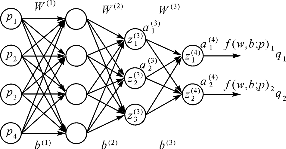
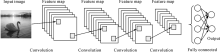
Fig.2
Typical convolutional neural network structure"

Fig.3
Two-channel deep convolutional neural network"

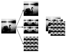
Fig.4
Image pyramid process in the neural network"

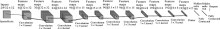
Fig.5
Based-spatial-scale two-channel deep convolutional neural network"
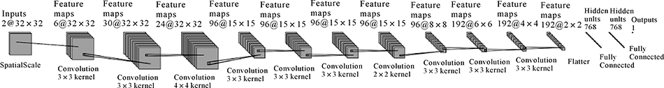
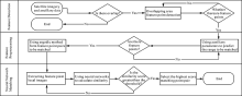
Fig.6
Satellite image matching process based on deep convolutional neural network"

Tab.1
Information on experimental data"
| Dataset name | Data Sources | Training set size | Test set size |
|---|---|---|---|
| GFG | 30-meter resolution Google satellite imagery 50-meter resolution GaoFen4 satellite imagery | 200,000 feature point pairs 50% correct match pair 50% mismatched pair | 100,000 feature point pairs 50% correct match pair 50% mismatched pair |
| THD | 5-meter resolution TianHui satellite three-line array imagery | 200,000 feature point pairs 50% correct match pair 50% mismatched pair | 100,000 feature point pairs 50% correct match pair 50% mismatched pair |

Fig.7
Display of experimental data"
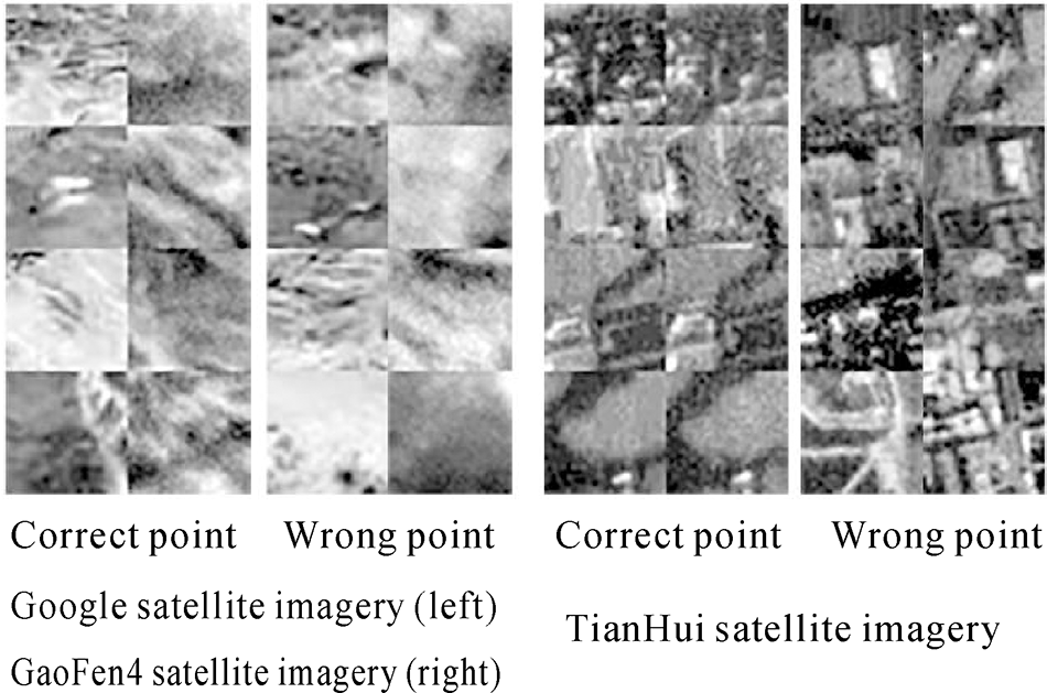
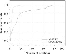
Fig.8
TPR results on the GFG training set"

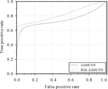
Fig.9
ROC results on the GFG test set"

Tab.2
Experimental results on the THD set%"
| Dataset name | TPR | FPR95 |
|---|---|---|
| THD Training set | 99.516 | 0.024 |
| THD Test set | 99.100 | 0.164 |

Fig.10
Image data for matching contrast experiments"

Tab.3
The methods of the experiments"
| Serial number | Feature detection | Feature description | Descriptor matching |
|---|---|---|---|
| 1 | sift | sift | ANN |
| 2 | surf | surf | ANN |
| 3 | KAZE | KAZE | BF |
| 4 | AKAZE | AKAZE | BF |
| 5 | ORB | ORB | BF-Hamming |
| 6 | BRISK | BRISK | BF |
| 7 | FAST | SIFT | ANN |
| 8 | AGAST | SIFT | ANN |
| 9 | Harris | SIFT | ANN |
| 10 | Shi-Tomasi | SIFT | ANN |
Tab.4
Matching results"
| Serial number | Comparative experimental method | Feature points of Google image | Feature points of GaoFen4 image | The matching number of traditional method | The matching number of traditional method and RANSAC | The matching correct rate of traditional method and RANSAC/(%) | The matching number of BSS- 2chDCNN | The matching number of BSS-2ch DCNN and RANSAC | The matching correct rate of BSS-2ch DCNN and RANSAC/(%) |
|---|---|---|---|---|---|---|---|---|---|
| 1 | sift | 10905 | 831 | 23 | 5 | 0.00 | 320 | 32 | 93.75 |
| 2 | surf | 21837 | 6615 | 140 | 5 | 20.00 | 4017 | 124 | 100.00 |
| 3 | KAZE | 2659 | 608 | 5 | 4 | 50.00 | 122 | 14 | 92.86 |
| 4 | AKAZE | 2293 | 491 | 186 | 5 | 0.00 | 118 | 20 | 95.00 |
| 5 | ORB | 5000 | 2042 | 13 | 4 | 25.00 | 294 | 100 | 100.00 |
| 6 | BRISK | 8021 | 333 | 436 | 7 | 14.29 | 117 | 12 | 100.00 |
| 7 | FAST+sift | 65178 | 2812 | 991 | 14 | 21.43 | 1682 | 65 | 98.46 |
| 8 | AGAST+sift | 71291 | 3305 | 1167 | 12 | 50.00 | 1993 | 87 | 98.85 |
| 9 | Harris+sift | 1924 | 961 | 0 | 0 | 0.00 | 43 | 26 | 100.00 |
| 10 | Shi-Tomasi+sift | 8781 | 9115 | 0 | 0 | 0.00 | 3913 | 296 | 100.00 |

Fig.11
Matching results based on sift"
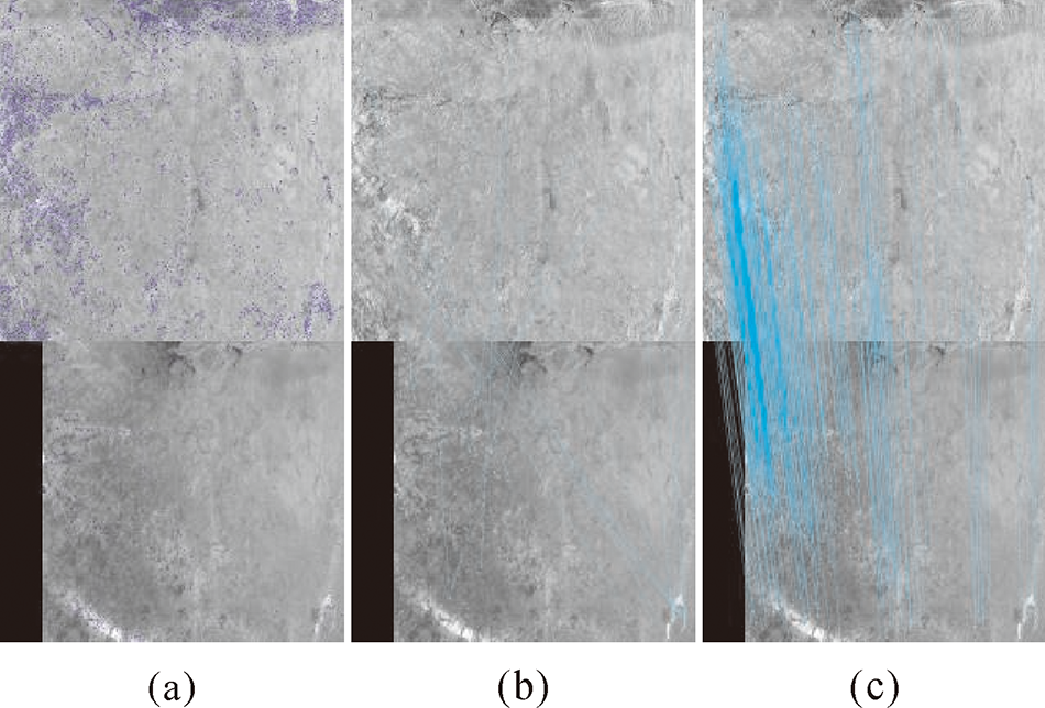
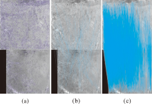
Fig.12
Matching results based on surf"

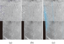
Fig.13
Matching results based on KAZE"


Fig.14
Matching results based on AKAZE"


Fig.15
Matching results based on ORB"

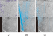
Fig.16
Matching results based on BRISK"
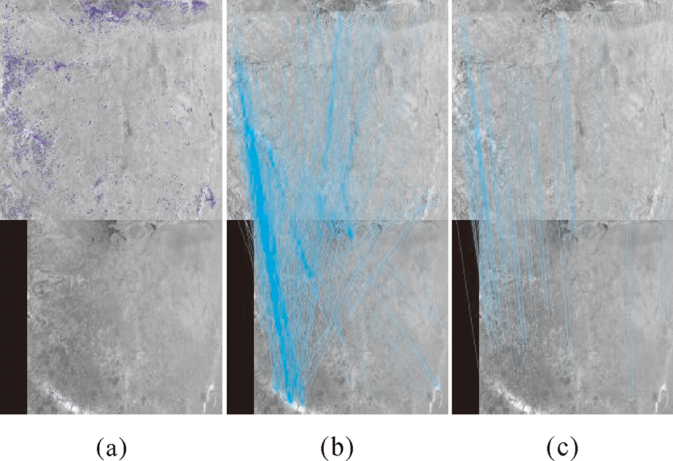

Fig.17
Matching results based on FAST+sift"

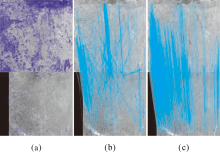
Fig.18
Matching results based on Agast+sift"
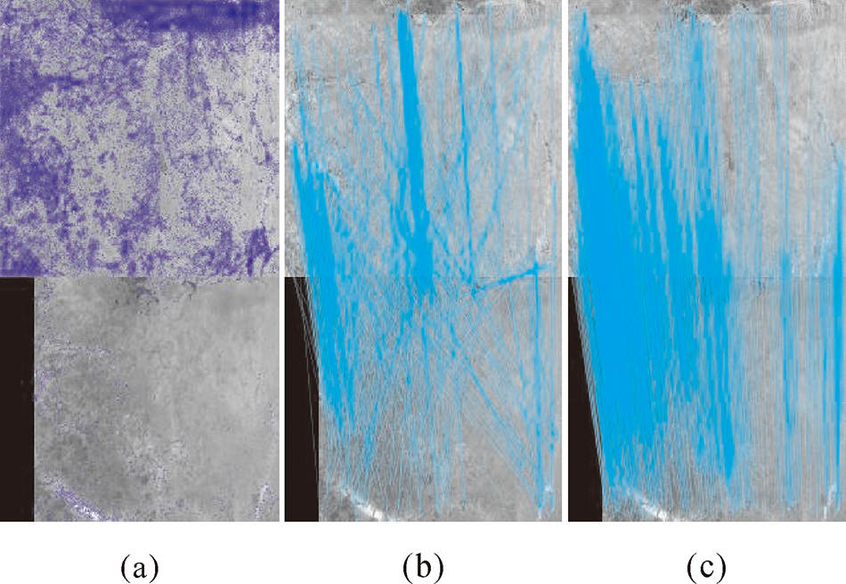
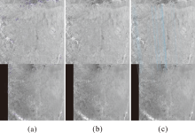
Fig.19
Matching results based on Harris+sift"
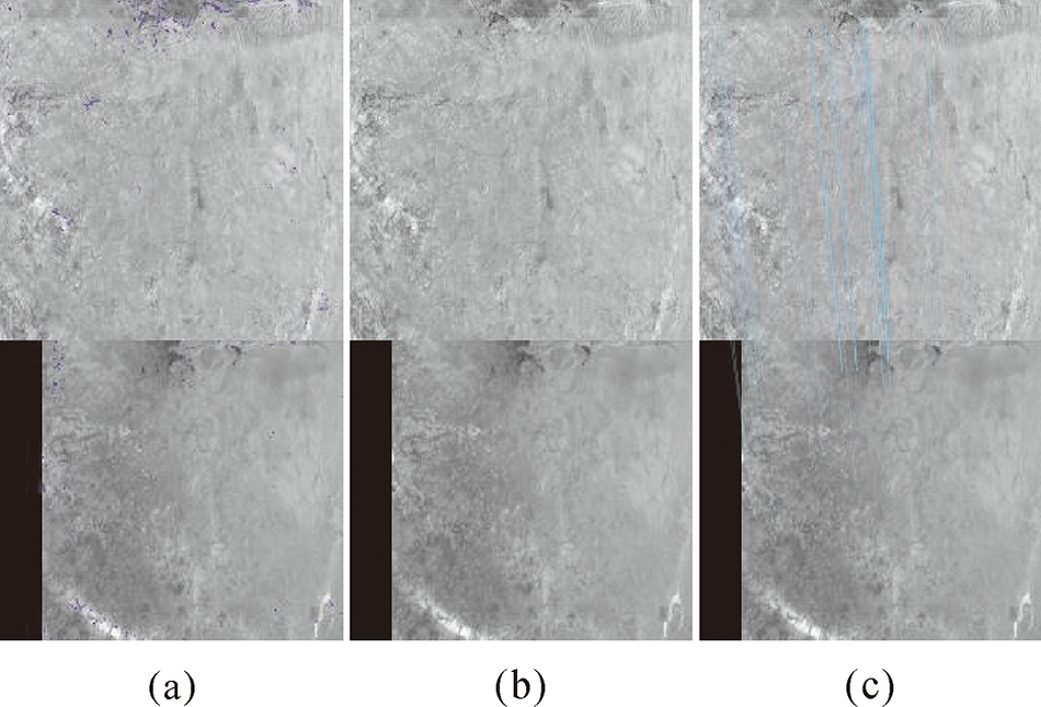

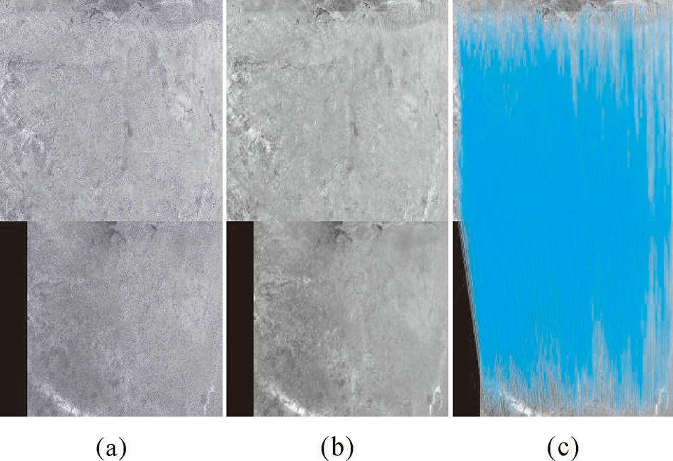
Fig.20
Matching results based on Shi-Tomasi+sift"
| [1] | LI Deren . Towards Geo-Spatial Information Science in Big Data Era[J]. Acta Geodaetica et Cartographica Sinica, 2016,45(4):379-384. |
| [2] | LI Deren, ZHANG Liangpei, Xia Guisong . Automatic Analysis and Mining of Remtoe Sensing Big Data[J]. Acta Geodaetica et Cartographica Sinica, 2014,43(12):1211-1216. |
| [3] | YAN Guoping, HE Junfeng . Extended Laplacian of Gaussian Operator for Edge Detection[J]. Journal of Huazhong University of Science and Technology (Nature Science Edition), 2006,34(10):21-23. |
| [4] | ZHAO Wanjin, GONG Shengrong, LIU Chunping , et al. Adaptive Harris Corner Detection Algorithm[J]. Computer Engineering, 2008,34(10):212-214, 217. |
| [5] | LOWE D G . Distinctive Image Features from Scale-invariant Keypoints[J]. International Journal of Computer Vision, 2004,60(2):91-110. |
| [6] | KE Yan, SUKTHANKAR R . PCA-SIFT: A More Distinctive Representation for Local Image Descriptors [C]//Proceedings of the IEEE Computer Society Computer Vision and Pattern Recognition. Washington, DC: IEEE, 2004: 506-513. |
| [7] | BAY H, TUYTELAARS T, VAN GOOL L . SURF: Speeded up Robust Features[M] //LEONARDIS A, BISCHOF H, PINZ A. Computer Vision-ECCV 2006. Berlin: Springer, 2006: 404-417. |
| [8] | CALONDER M, LEPETIT V, STRECHA C , et al. BRIEF: Binary Robust Independent Elementary Features[M] //DANⅡLIDIS K, MARAGOS P, PARAGIOS N. Computer Vision-ECCV 2010. Berlin: Springer, 2010: 778-792. |
| [9] | CALONDER M, LEPETIT V, OZUYSAL M , et al. BRIEF:Computing a Local Binary Descriptor Very Fast[J]. IEEE Transactions on Pattern Analysis and Machine Intelligence, 2012,34(7):1281-1298. |
| [10] | XU Yunxi, CHEN Fang . Recent Advances in Local Image Descriptor[J]. Journal of Image and Graphics, 2015,20(9):1133-1150. |
| [11] | DONG Yang, FAN Dazhao, JI Song , et al. The Purification Method of Matching Points Based on Principal Component Analysis[J]. Acta Geodaetica et Cartographica Sinica, 2017,46(2):228-236. |
| [12] | FISCHER Philipp, ALEXEY Dosovitskiy, THOMAS Brox . Descriptor Matching with Convolutional Neural Networks: A Comparison to SIFT[J]. arXiv: Computer Vision and Pattern Recognition, 2014. |
| [13] | ŽBONTAR J, LECUN Y . Computing the Stereo Matching Cost with a Convolutional Neural Network [C]//IEEE Conference on Computer Vision and Pattern Recognition. Boston, MA: IEEE, 2015: 1592-1599. |
| [14] | ZAGORUYKO S, KOMODAKIS N . Learning to Compare Image Patches via Convolutional Neural Networks [C]//IEEE Conference on Computer Vision and Pattern Recognition. Boston, MA: IEEE, 2015: 4353-4361. |
| [15] | HAN Xufeng, LEUNG T, JIA Yangqing , et al. MatchNet: Unifying Feature and Metric Learning for Patch-based Matching [C]//IEEE Conference on Computer Vision and Pattern Recognition. Boston, MA: IEEE, 2015: 3279-3286. |
| [16] | PAL S K, MITRA S . Multilayer Perceptron, Fuzzy Sets, Classification[J]. IEEE Transactions on Neural Networks, 1992,3(5):683-697. |
| [17] | TRAPPEY A J C, HSU F C, TRAPPEY C V , et al. Development of a Patent Document Classification and Search Platform Using a Back-propagation Network[J]. Expert Systems with Applications, 2006,31(4):755-765. |
| [18] | SZEGEDY C, LIU Wei, JIA Yangqing , et al. Going Deeper with Convolutions [C]//IEEE Conference on Computer Vision and Pattern Recognition. Boston, MA: IEEE, 2015: 1-9. |
| [19] | ŽBONTAR J, LECUN Y . Stereo Matching by Training A Convolutional Neural Network to Compare Image Patches[J]. The Journal of Machine Learning Research, 2016,17(1):2287-2318. |
| [20] | COLLOBERT R, KAVUKCUOGLU K, FARABET C . Torch7: A Matlab-like Environment for Machine Learning [C]//Neural Information Processing Systems Workshop. [s. l]: BigLearn, 2011. |
| [21] | CHEN Tianqi, LI Mu, LI Yutian , et al. MXNet: A Flexible and Efficient Machine Learning Library for Heterogeneous Distributed Systems[R]. Nanjin: Neural Information Processing Systems, Workshop on Machine Learning Systems, 2015. |
| [22] | CHETLUR Sharan, WOOLLEY Cliff, VANDERMERSCH Philippe , et al. cuDNN: Efficient Primitives for Deep Learning[J]. arXiv preprint arXiv: 1410. 0759, 2014. |
| [23] | XU Wei . Towards Optimal One Pass Large Scale Learning with Averaged Stochastic Gradient Descent[J]. arXiv preprint arXiv: 1107.2490, 2011. |
| [24] | BROWN M, HUA Gang, WINDER S . Discriminative Learning of Local Image Descriptors[J]. IEEE Transactions on Pattern Analysis and Machine Intelligence, 2011,33(1):43-57. |
| [25] | DU Yulong, LI Jianzeng, ZHANG Yan , et al. Saliency Detection Based on Deep Cross CNN and Non-interaction GrabCut[J]. Computer Engineering and Applications, 2017,53(3):32-40. |
| [26] | PABLO F Alcantarilla, ADRIEN Bartoli, JESUS Nuevo . KAZE Features [C]//European Conference on Computer Vision, 2012. |
| [27] | PABLO F Alcantarilla, JESUS Nuevo, ADRIEN Bartoli . Fast explicit diffusion for accelerated features in nonlinear scale spaces [C]//British Machine Vision Conference, 2013. |
| [28] | ETHAN Rublee, VINCENT Rabaud, KURT Konolige , et al. ORB: An efficient alternative to SIFT or SURF [C]//IEEE International Conference on Computer Vision, 2012. |
| [29] | STEFAN Leutenegger, MARGARITA Chli, ROLAND Y . Siegwart. BRISK: Binary robust invariant scalable keypoints [C]//IEEE International Conference on Computer Vision, 2011. |
| [30] | EDWARD Rosten, T Drummond . Machine learning for high-speed corner detection [C]//European Conference on Computer Vision, 2006. |
| [31] | ELMAR Mair, GREGORY D Hager, DARIUS Burschka , et al. Adaptive and generic corner detection based on the accelerated segment test [C]//European Conference on Computer Vision, 2010. |
| [32] | HARRIS C, STEPHENS M . A Combined Corner and Edge Detector [C]// Proceedings of the 4th Alvey Vision Conference. Manchester: Springer, 1988: 147-151. |
| [33] | SHI Jianbo, TOMASI . Good features to track [C]//IEEE Conference on Computer Vision and Pattern Recognition, 1994: 593-600. |
| [1] | Kexian WANG,Shunyi ZHENG,Rui LI,Li GUI. A Deep Double-Channel Dense Network for Hyperspectral Image Classification [J]. Journal of Geodesy and Geoinformation Science, 2021, 4(4): 46-62. |
| [2] | Yanjun WANG,Shaochun LI,Mengjie WANG,Yunhao LIN. A Simple Deep Learning Network for Classification of 3D Mobile LiDAR Point Clouds [J]. Journal of Geodesy and Geoinformation Science, 2021, 4(3): 49-59. |
| [3] | Long SUN, Tao WU, Guangcai SUN, Dazheng FENG, Lieshu TONG, Mengdao XING. Object Detection Research of SAR Image Using Improved Faster Region-Based Convolutional Neural Network [J]. Journal of Geodesy and Geoinformation Science, 2020, 3(3): 18-28. |
| [4] | Hao HE,Shuyang WANG,Shicheng WANG,Dongfang YANG,Xing LIU. A Road Extraction Method for Remote Sensing Image Based on Encoder-Decoder Network [J]. Journal of Geodesy and Geoinformation Science, 2020, 3(2): 16-25. |
| [5] | Yun ZHANG. Smart Photogrammetric and Remote Sensing Image Processing for Very High Resolution Optical Images— Examples from the CRC-AGIP Lab at UNB [J]. Journal of Geodesy and Geoinformation Science, 2019, 2(2): 17-26. |
| [6] | Jianya GONG,Shunping JI. Photogrammetry and Deep Learning [J]. Journal of Geodesy and Geoinformation Science, 2018, 1(1): 1-15. |
| [7] | Taoyang WANG,Guo ZHANG,Deren LI,Wanshou JIANG,Xinming TANG,Xuelin LIU. Comparison between Plane and Stereo Block Adjustment for ZY-3 Satellite Images [J]. Journal of Geodesy and Geoinformation Science, 2018, 1(1): 53-60. |
| Viewed | ||||||
|
Full text |
|
|||||
|
Abstract |
|
|||||