
Journal of Geodesy and Geoinformation Science ›› 2022, Vol. 5 ›› Issue (2): 7-18.doi: 10.11947/j.JGGS.2022.0202
• Special Issue • Previous Articles Next Articles
Xuchen JIANG1( ),Meng WANG2,Gang XU1,Bingwang FANG3,Kun QIN1,Rui XIAO1()
Received:2021-10-11
Accepted:2022-02-03
Online:2022-06-20
Published:2022-07-22
Contact:
Rui XIAO
E-mail:554229448@qq.com;rxiao@whu.edu.cn
About author:Xuchen JIANG, E-mail: Supported by:Xuchen JIANG,Meng WANG,Gang XU,Bingwang FANG,Kun QIN,Rui XIAO. Urban Development Boundary Simulation Based on “Double Evaluation” and FLUS Model[J]. Journal of Geodesy and Geoinformation Science, 2022, 5(2): 7-18.
Add to citation manager EndNote|Reference Manager|ProCite|BibTeX|RefWorks
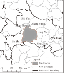
Fig.1
Study area"
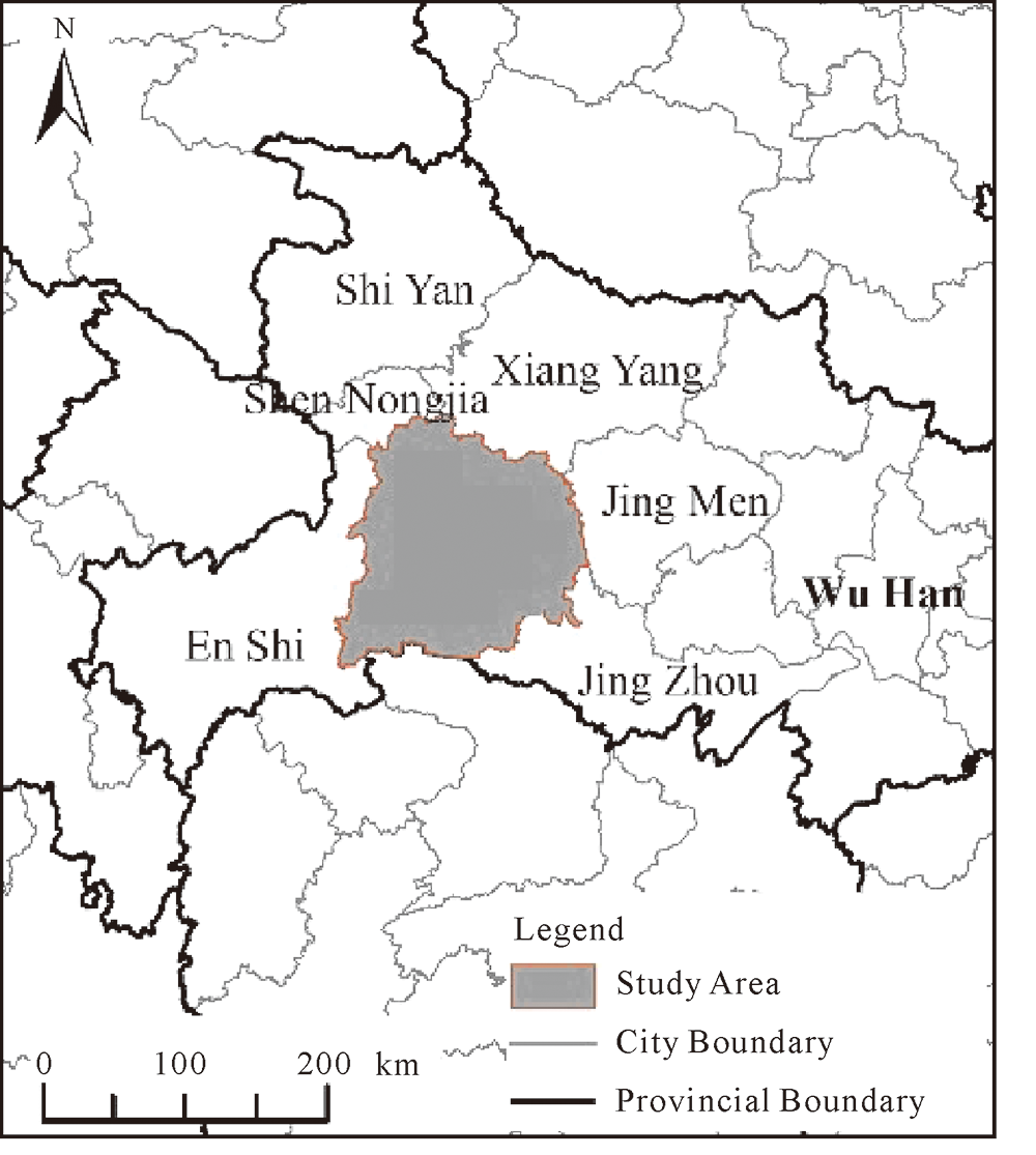

Fig.2
Land use maps of Yichang in 2012 and 2018"
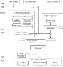
Fig.3
Technical route for delimiting urban development boundary in Yichang"
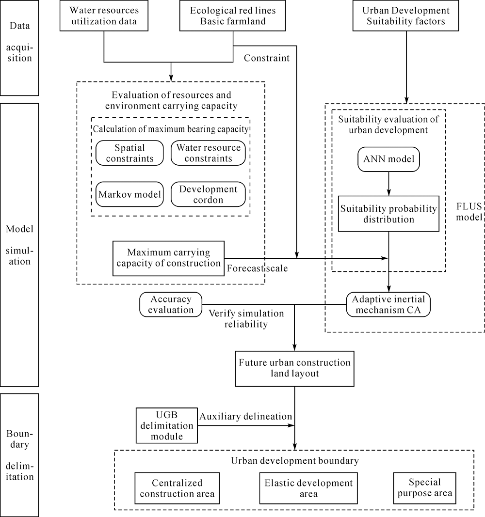
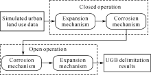
Fig.4
UGB assisted delineation module operating mechanism"

Fig.5
Impact factors of suitability evaluation in Yichang"
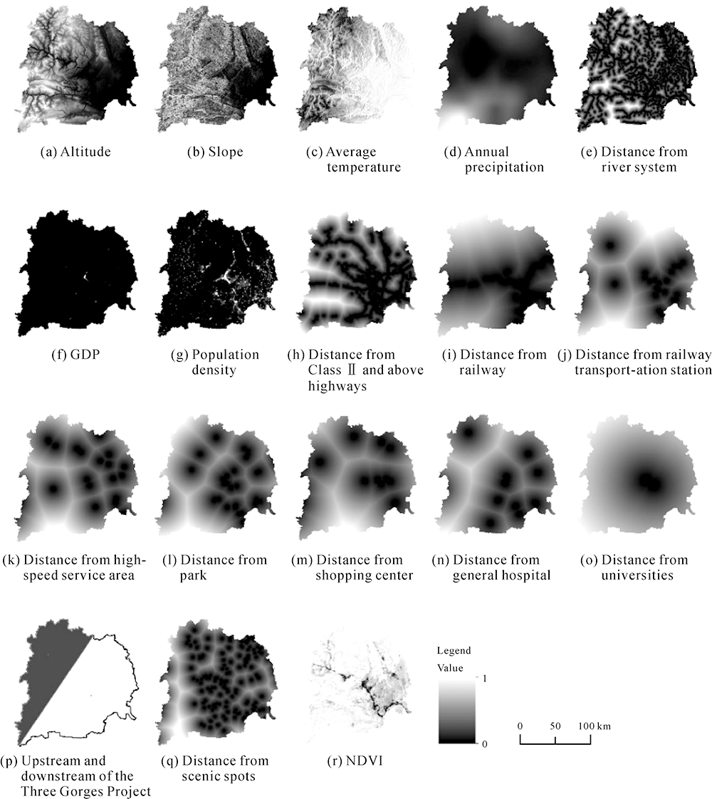

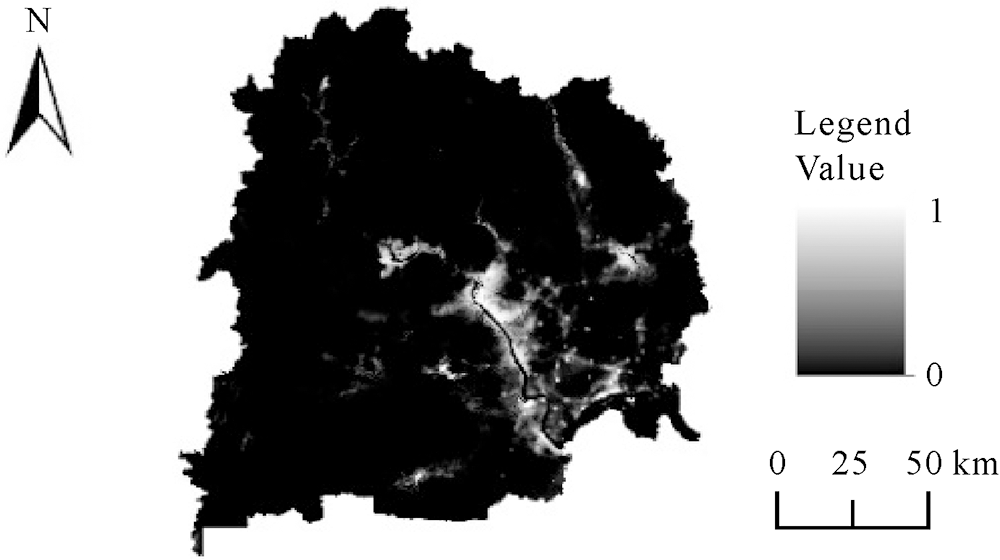
Fig.6
Suitability evaluation results of LULC for construction in Yichang"
Tab.1
Prediction of LUCC area in Yichang km2"
| Particular year | Urban construction land | Forest and grassland | Garden plot | Water | Cultivated land | Other Construction land | Other |
|---|---|---|---|---|---|---|---|
| 2012 | 291.33 | 13570.52 | 1608.26 | 672.95 | 3896.67 | 793.20 | 397.07 |
| 2018 | 334.13 | 13592.79 | 1589.82 | 677.33 | 3863.77 | 777.33 | 394.83 |
| 2035 | 481.63 | 13665.02 | 1526.74 | 692.38 | 3751.39 | 725.75 | 387.09 |
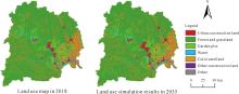
Fig.7
Simulation results in Yichang from 2018 to 2035"

Fig.8
Result of delimiting urban centralized construction area in Yichang"
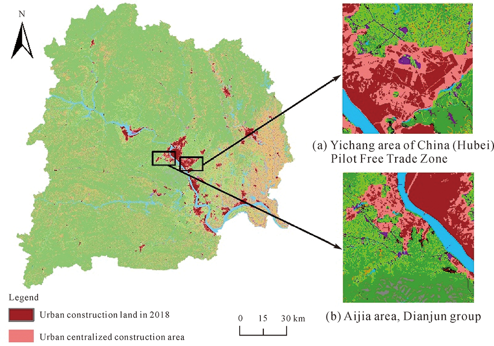
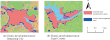
Fig.9
The delimitation of urban elastic development area in some areas of Yichang"


Fig.10
The delimitation of special-purpose area in some areas of Yichang"
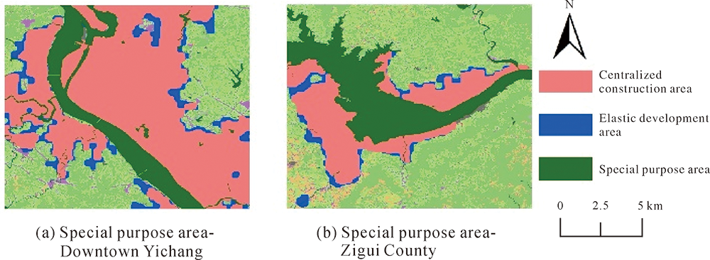

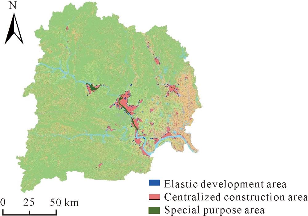
Fig.11
Result of delimiting the development boundary of 2035 town in Yichang"
Tab.2
Occupancy of other LULC by urban development boundary in Yichangkm2"
| Category | Area |
|---|---|
| Forest and grassland | 45.78 |
| Garden plot | 87.43 |
| Water | 9.38 |
| Cultivated land (basic farmland) | 78.02(4.83) |
| Other construction land | 83.89 |
| Other | 17.82 |

Fig.12
The main growth areas of urban construction land in the central urban area of Yichang in 2035"

| [1] |
GONG Yinxi, LIU Ruomei, WANG Faliang, et al. Spatial function identification of city-and county-level land spatial planning based on information integration[J]. Journal of Natural Resources, 2021, 36(8): 2006-2019.
doi: 10.31497/zrzyxb.20210808 |
| [2] | XU Huan, FU Bihong, GUO Qiang, et al. Temporal-spatial growth pattern and driving forces of urban expansion in Xi’an over past 30 years[J]. Journal of Remote Sensing, 2018, 22(2): 347-359. |
| [3] | Ministry of Natural Resources. Guidelines for compiling general land and space planning at the municipal level[R]. Beijing: Ministry of Natural Resources, 2020. |
| [4] | Ministry of Natural Resources. Guidelines for delimiting urban boundary development[R]. Beijing: Ministry of Natural Resources, 2019. |
| [5] |
NING Xiaogang, WANG Hao, LIN Xiangguo, et al. Spatio-temporal urban sprawl monitoring and analysis over Beijing-Tianjin-Hebei urban agglomeration during 1990—2015[J]. Acta Geodaetica et Cartographica Sinica, 2018, 47(9): 1207-1215. DOI: 10.11947/j.AGCS.2018.20170414.
doi: 10.11947/j.AGCS.2018.20170414 |
| [6] | LI Yonghua. Method of determining urban growth boundary from the view of ecology: a case study of Hangzhou[J]. City Planning Review, 2011, 35(12): 83-90. |
| [7] |
LI Xia, LI Dan, LIU Xiaoping. Geographical simulation and optimization System (GeoSOS) and its application in the analysis of geographic national conditions[J]. Acta Geodaetica et Cartographica Sinica, 2017, 46(10): 1598-1608. DOI: 10.11947/j.AGCS.2017.20170355.
doi: 10.11947/j.AGCS.2017.20170355 |
| [8] | ZHOU Daojing, XU Yong, WANG Yafei, et al. Methodology and role of “double evaluation” in optimization of spatial development pattern[J]. Bulletin of Chinese Academy of Sciences, 2020, 35(7): 814-824. |
| [9] |
XU Qiurong, ZHENG Xinqi. Analysis of influencing mechanism of urban growth using geographical detector[J]. Acta Geodaetica et Cartographica Sinica, 2015, 44(S1): 96-101. DOI: 10.11947/j.AGCS.2015.F064.
doi: 10.11947/j.AGCS.2015.F064 |
| [10] | Ministry of Natural Resources. Guidelines for assessment of resource and environment bearing capacity and suitability for land and space development[R]. Beijing: Ministry of Natural Resources, 2020. |
| [11] |
WANG Yafei, FAN Jie, ZHOU Kan. Territorial function optimization regionalization based on the integration of “Double Evaluation”[J]. Geographical Research, 2019, 38(10): 2415-2429.
doi: 10.11821/dlyj020190327 |
| [12] |
LI Xia, CHEN Yimin, LIU Xiaoping, et al. Concepts, methodologies, and tools of an integrated geographical simulation and optimization system[J]. International Journal of Geographical Information Science, 2011, 25(4): 633-655.
doi: 10.1080/13658816.2010.496370 |
| [13] | LUO Weiling, WU Xinxin, LIU Xiaoping, et al. Empirical research on the delimitation of urban development boundary in the background of “dual-evaluation”—a case study of Zhongshan City[J]. Journal of Urban and Regional Planning, 2019, 11(1): 65-78. |
| [14] | ZHAO Xuan, PENG Jiandong, FAN Zhiyu, et al. Land use simulation and urban growth boundaries delineation in Wuhan metropolitan area based on FLUS model and “dual environment evaluation”[J]. Journal of Geo-Information Science, 2020, 22(11): 2212-2226. |
| [15] |
XIANG Guangxin, FU Jinhao, ZENG Liting, et al. Demarcation technology of urban development boundary based on evaluation of carrying capacity of resources environment and suitability of land space development: a case study of the central city of Xiangtan County[J]. Journal of Natural Resources, 2020, 35(10): 2401-2414.
doi: 10.31497/zrzyxb.20201008 |
| [16] | LI Deren. On the role of the digital province or/and city in the territorial planning and construction of the city and town[J]. Acta Geodaetica et Cartographica Sinica, 2002, 31(S1): 16-21. |
| [17] | WANG Bei. Urban expansion simulation of coupled planning space control and demarcation of urban development boundaries[D]. Wuhan: Wuhan University, 2018. |
| [18] | GUO Xuhong, QU Shang. Strategic positioning and design of regional development—evidence from Hubei Province[J]. East China Economic Management, 2015, 29(4): 64-70. |
| [19] | YUAN Jingwen, WU Chen, DU Bo, et al. Analysis of landscape pattern on urban land use based on GF-5 hyperspectral data[J]. Journal of Remote Sensing, 2020, 24(4): 465-478. |
| [20] | Hubei Provincial People’s government. Notice of Hubei provincial people’s government on issuing the red line of ecological protection in Hubei Province[R]. Wuhan: Hubei Provincial People’s Government, 2018. |
| [21] | Yichang Municipal People’s Government. Adjustment and improvement results of Yichang general land use planning (2006—2020)[R]. Yichang: Yichang Municipal People’s Government, 2017. |
| [22] |
FAN Jie, ZHOU Kan, CHEN Dong. Innovation and practice of economic geography for optimizing spatial development pattern in construction of ecological civilization[J]. Economic Geography, 2013, 33(1): 1-8.
doi: 10.2307/142563 |
| [23] | LU Zhangwei, XU Lihua, WU Yaqi. Spatial distribution of construction land of central urban area based on suitability evaluation—a case study of Hangzhou[J]. Resources and Environment in The Yangtze Basin, 2016, 25(6): 904-912. |
| [24] |
ZHANG Dachuan, LIU Xiaoping, LIN Ziyu, et al. The delineation of urban growth boundaries in complex ecological environment areas by using cellular automata and a dual-environmental evaluation[J]. Journal of Cleaner Production, 2020, 256: 120361.
doi: 10.1016/j.jclepro.2020.120361 |
| [25] | HU Weiping, HE Jianbang. Built-up land-cover change monitoring by remote sensing of urban area in the pearl river delta based on GIS[J]. Journal of Remote Sensing, 2003, 7(3): 201-206, 244. |
| [26] | LUO Jiancheng, WANG Qinmin, ZHOU Chenghu, et al. Adaptive resonance theory for classification of remotely sensed image[J]. Acta Geodaetica et Cartographica Sinica, 2002, 31(2): 145-150. |
| [27] |
LIANG Xun, LIU Xiaoping, LI Dan, et al. Urban growth simulation by incorporating planning policies into a CA-based future land-use simulation model[J]. International Journal of Geographical Information Science, 2018, 32(11): 2294-2316.
doi: 10.1080/13658816.2018.1502441 |
| [28] | LI Xia, LIU Xiaoping. Spatial information technology for facilitating “three-plan integration” using geographical simulation and optimization[J]. Journal of Remote Sensing, 2016, 20(5): 1308-1318. |
| [29] |
KE Xinli, QI Lingyun, ZENG Chen. A partitioned and asynchronous cellular automata model for urban growth simulation[J]. International Journal of Geographical Information Science, 2016, 30(4): 637-659.
doi: 10.1080/13658816.2015.1084510 |
| [30] |
LIU Xiaoping, LIANG Xun, LI Xia, et al. A future land use simulation model (FLUS) for simulating multiple land use scenarios by coupling human and natural effects[J]. Landscape and Urban Planning, 2017, 168: 94-116.
doi: 10.1016/j.landurbplan.2017.09.019 |
| [31] |
LIANG Xun, LIU Xiaoping, LI Xia, et al. Delineating multi-scenario urban growth boundaries with a CA-Based FLUS model and morphological method[J]. Landscape and Urban Planning, 2018, 177: 47-63.
doi: 10.1016/j.landurbplan.2018.04.016 |
| [32] |
LIANG Xun, LIU Xiaoping, CHEN Guangliang, et al. Coupling fuzzy clustering and cellular automata based on local maxima of development potential to model urban emergence and expansion in economic development zones[J]. International Journal of Geographical Information Science, 2020, 34(10): 1930-1952.
doi: 10.1080/13658816.2020.1741591 |
| [33] | Yichang Ecological Environment Bureau. Yichang environmental master plan (2013—2030)[R]. Yichang: Yichang Ecological Environment Bureau, 2017. |
| [34] | Yichang Water Resources and Lakes Bureau. 2017 Yichang water resources bulletin[R]. Yichang: Yichang Water Resources and Lakes Bureau, 2018. |
| [35] | Yichang Water Resources and Lakes Bureau. 2018 Yichang water resources bulletin[R]. Yichang: Yichang Water Resources and Lakes Bureau, 2019. |
| [36] | Department of Urban Construction, Ministry of Construction. GB/T 50331—2002 The standard of water quantity for city’s residential use[S]. Beijing: China Architecture & Building Press, 2002. |
| [37] | Ministry of Housing and Urban-Rural Development of the People’s Republic of China. GB 50137—2011 Code for classification of urban land use and planning standards of development land[S]. Beijing: China Planning Press, 2012. |
| [38] | Yichang City Planning Bureau. Recent construction plan of Yichang city center (2017—2020)[R]. Yichang: Yichang City Planning Bureau, 2018. |
| [39] | CHEN Xiangsheng. Problems of development of Yichang free trade zone and the countermeasures[J]. Journal of China Three Gorges University (Humanities & Social Sciences), 2020, 42(5): 68-73. |
| [40] | WEI Xuhong, KAI Xin, WANG Ying, et al. Discussions on the methods of “three zones and three lines” implementation at the spatial levels of city and county based on “double evaluations”[J]. City Planning Review, 2019, 43(7): 10-20. |
| [41] |
FAN Jie. Spatial organization pathway for territorial function-structure: discussion on implementation of major function zoning strategy in territorial spatial planning[J]. Geographical Research, 2019, 38(10): 2373-2387.
doi: 10.11821/dlyj020190865 |
| No related articles found! |
| Viewed | ||||||
|
Full text |
|
|||||
|
Abstract |
|
|||||