
Journal of Geodesy and Geoinformation Science ›› 2022, Vol. 5 ›› Issue (1): 25-38.doi: 10.11947/j.JGGS.2022.0104
• Special Issue • Previous Articles Next Articles
Bing XU( ),Liqun LIU,Zhiwei LI(),Yan ZHU,Jingxin HOU,Wenxiang MAO
Received:2021-08-16
Accepted:2021-12-05
Online:2022-03-20
Published:2022-03-31
Contact:
Zhiwei LI
E-mail:xubing@csu.edu.cn;zwli@csu.edu.cn
About author:Bing XU (1986—), male, PhD, associate professor, majors in InSAR data processing method development. E-mail: Supported by:Bing XU,Liqun LIU,Zhiwei LI,Yan ZHU,Jingxin HOU,Wenxiang MAO. Design Bistatic Interferometric DEM Generation Algorithm and Its Theoretical Accuracy Analysis for LuTan-1 Satellites[J]. Journal of Geodesy and Geoinformation Science, 2022, 5(1): 25-38.
Add to citation manager EndNote|Reference Manager|ProCite|BibTeX|RefWorks

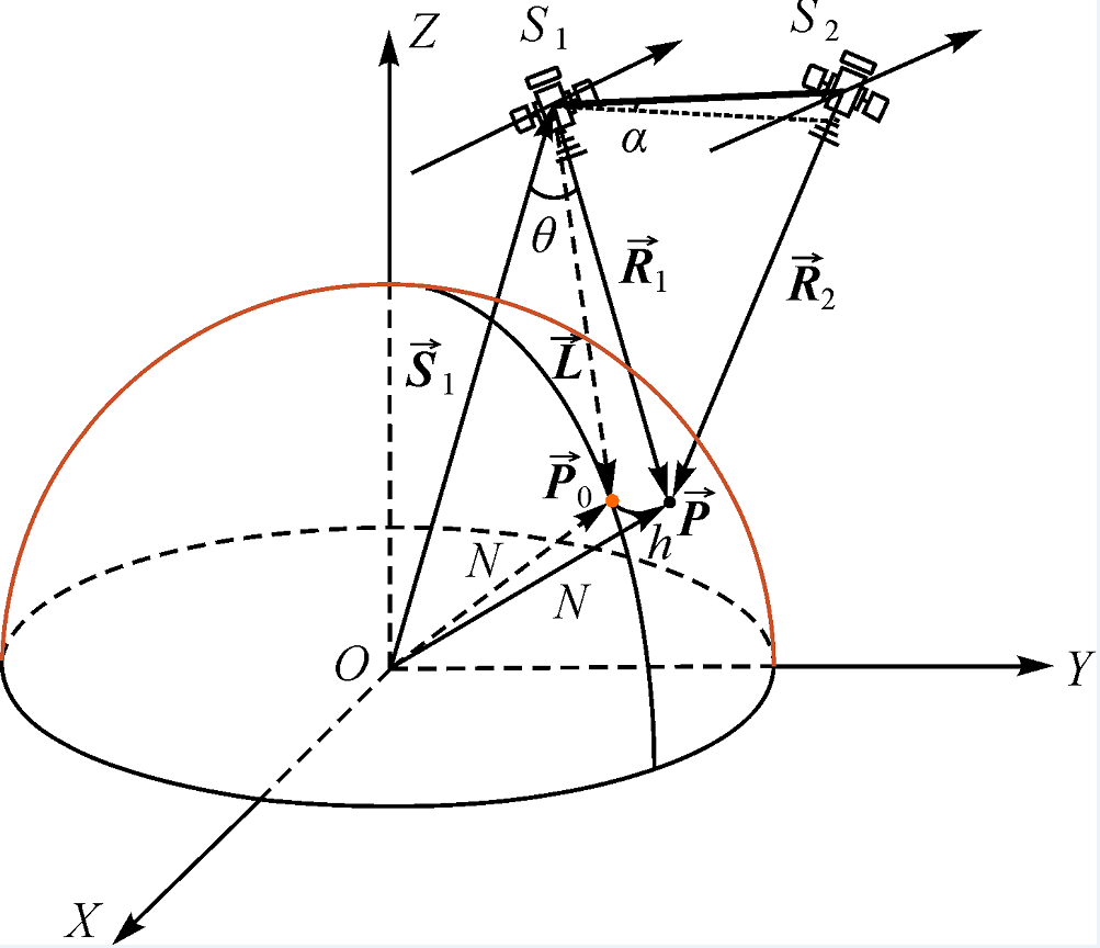
Fig.1
Geometric sketch of InSAR 3D reconstruction"
Tab.1
Pseudo-code of algorithm implementation"
| /* /*R1 is the master satellite’s slant range and it shall be computed for each column. Doppler centroid fd is computed from the doppler polynomial. */ /*Φ is the two-dimensional unwrapped interferometric phases, which consists of flat-earth and topographic phase components. */ /* LON, LAT, HEI are longitude, latitude and height matrix to store the geodetic coordinates, and they have same dimension of Φ. */ 1 Begin 2 Read unwrapped phase Φ and SAR geometry parameters 3 for each row do 4 compute 5 compute baseline 6 construct Rvpq 7 For each column do 8 compute slant range R1 and doppler centroid fd 9 Get phase φ at Φ and compute ΔR with Eq. (10) 10 compute 11 compute lv with Eq. (7) 12 compute lp with Eqs. (8) and (9) 13 compute lq with Eqs. (11) and (14) 14 compute 15 compute 16 save 17 end 18 End 19 Write LON, LAT and HEI results to file 20 End |
Tab.2
Values of parameters for simulation scenario"
| Parameter | Value |
|---|---|
| Master satellite position | Sx=-1823415.5m, Sy=4947197.6m, Sz=4435945.3m |
| Master satellite velocity | Vx=3242.1m/s, Vy=-3957.4m/s, Vz=5729.7m/s |
| Slave satellite position | Sx=-1822928.1m, Sy=4947067.2m, Sz=4435702.2m |
| Radar wavelength | λ=0.236m |
| Image time | Start time t0=65493.87s, Center time tc=65497.29s, End time t1=65500.71s |
| Baseline initial value in TCN | Bt,0=0.0m, Bc,0=-401.6440m, Bn,0=379.0245m |
| Baseline velocity value in TCN | αt=0.0m, αc=0.42970m/s, αn=-0.03478m/s |
| Range | R1=713436.279m, R2=713421.289m |
| Doppler centroid | fd=16.38Hz |

Fig.2
Theoretic accuracy of the implemented algorithm (The purple line is a probability density function of the normal distribution with mean μ=0 and standard deviation σ=0.012m)"
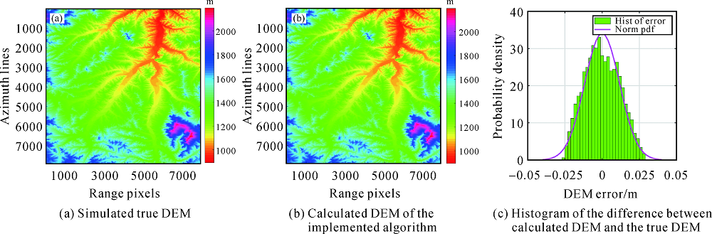
Fig.3
Results of master satellite state vector sensitivity"
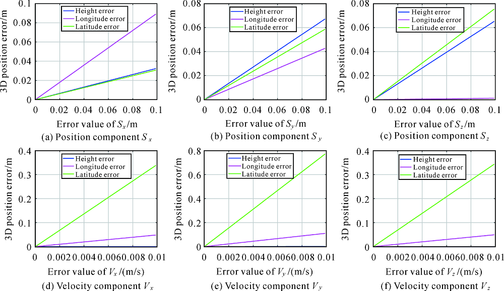
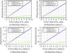
Fig.4
Results of baseline sensitivity in TCN"
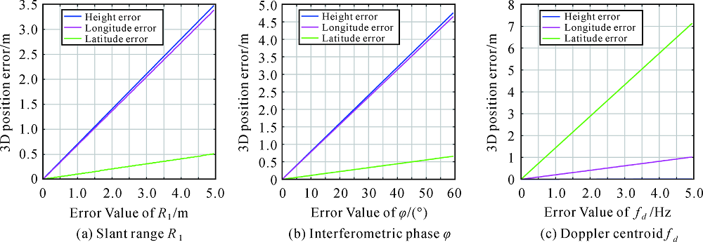
Fig.5
Results of sensitivity for other parameters"
Tab.3
The proportionality factors between the height error and parameter errors"
| Errors | Factor k | Correlation R2 | Error led to Δh=2m |
|---|---|---|---|
| ΔSx | 0.3269 | 0.9912 | ΔSx=6.118m |
| ΔSy | 0.6788 | 0.9998 | ΔSy=2.946m |
| ΔSz | 0.6581 | 0.9785 | ΔSz=3.039m |
| ΔVx | 0.0 | 0.9692 | / |
| ΔVy | 0.0 | 0.9942 | / |
| ΔVz | 0.0 | 0.9703 | / |
| ΔBc,0 | 505.2 | 0.9997 | ΔBc,0=0.0040m |
| ΔBn,0 | 592.6 | 0.9996 | ΔBn,0=0.0034m |
| Δαc | 505.3 | 0.9996 | Δαc=0.0040m/s |
| Δαn | 592.5 | 0.9997 | Δαn=0.0034m/s |
| ΔR1 | 0.7025 | 0.9962 | ΔR1=2.847m |
| Δφ | 0.0798 | 0.9885 | Δφ=25.06° |
| Δfd | 0.0036 | 0.9932 | Δfd=555.56Hz |
Tab.4
Errors control to obtain a accuracy of 2 m for LT-1 DEM generation"
| Errors | ΔR1 | Δφ | ΔBc,0 | ΔBn,0 | Δαc | Δαn |
|---|---|---|---|---|---|---|
| Equal to or better than | 0.6m | 5 ° | 1.0mm | 1.0mm | 0.03mm/s | 0.03mm/s |
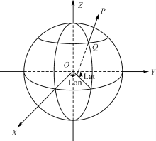
Fig.A1
Geometric sketch of ECEF coordinate"
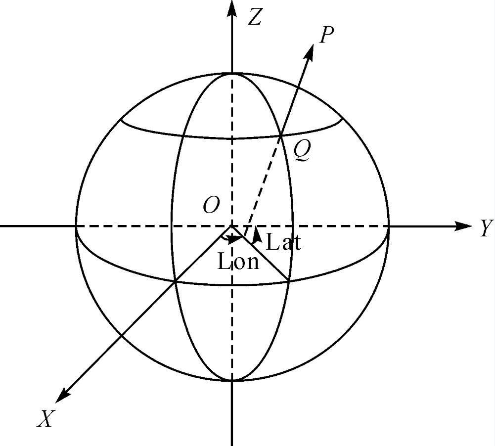
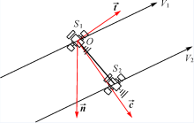
Fig.A2
Geometric sketch of TCN coordinate"
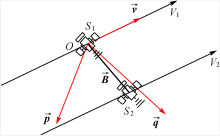
Fig.A3
Geometric sketch of VPQ"
| [1] |
GRAHAM L C. Synthetic interferometer radar for topographic mapping[J]. Proceedings of the IEEE, 1974, 62(6): 763-768. DOI: 10.1109/PROC.1974.9516.
doi: 10.1109/PROC.1974.9516 |
| [2] |
ZEBKER H A, GOLDSTEINRM. Topographic mapping from interferometric synthetic aperture radar observations[J]. Journal of Geophysical Research: Solid Earth, 1986, 91(B5): 4993-4999. DOI: 10.1029/JB091iB05p04993.
doi: 10.1029/JB091iB05p04993 |
| [3] |
GOLDSTEINRM, ZEBKERHA, WERNERCL. Satellite radar interferometry: two-dimensional phase unwrapping[J]. Radio Science, 1988, 23(4): 713-720. DOI: 10.1029/RS023i004p00713.
doi: 10.1029/RS023i004p00713 |
| [4] |
LIN Q, VESECKY J F, ZEBKER H A. Comparison of elevation derived from InSAR data with DEM over large relief terrain[J]. International Journal of Remote Sensing, 1994, 15(9): 1775-1790.DOI: 10.1080/01431169408954208.
doi: 10.1080/01431169408954208 |
| [5] |
VAN ZYLJJ, The shuttle radar topography mission (SRTM): a breakthrough in remote sensing of topography[J]. Acta Astronautica, 2001, 48(5-12): 559-565. DOI: 10.1016/S0094-5765(01)00020-0.
doi: 10.1016/S0094-5765(01)00020-0 |
| [6] |
YAGUE-MARTINEZ N, ROSSI R, LACHAISE M, et al. Interferometric processing algorithms of TanDEM-X data[C]// Proceedings of 2010 IEEE International Geoscience and Remote Sensing Symposium. Honolulu: IEEE, 2010: 3518-3521. DOI: 10.1109/IGARSS.2010.5652406.
doi: 10.1109/IGARSS.2010.5652406 |
| [7] |
DEO R, MANICKAM S, RAO Y S, et al. Evaluation of interferometric SAR DEMs generated using TanDEM-X data[C]// Proceedings of 2013 IEEE International Geoscience and Remote Sensing Symposium-IGARSS. Melbourne: IEEE, 2013: 2079-2082. DOI: 10.1109/IGARSS.2013.6723221.
doi: 10.1109/IGARSS.2013.6723221 |
| [8] |
KRIEGER G, MOREIRA A, FIEDLER H, et al. TanDEM-X: a satellite formation for high-resolution SAR interferometry[J]. IEEE Transactions on Geoscience and Remote Sensing, 2007, 45(11): 3317-3341. DOI: 10.1109/TGRS.2007.900693.
doi: 10.1109/TGRS.2007.900693 |
| [9] |
LOU Liangsheng, LIU Zhiming, ZHANG Hao, et al. TH-2 satellite engineering design and implementation[J]. Acta Geodaetica et Cartographica Sinica, 2020, 49(10): 1252-1264.DOI: 10.11947/j.AGCS.2020.20200175.
doi: 10.11947/j.AGCS.2020.20200175 |
| [10] |
LACHAISE M, FRITZ T, BREITH. InSAR processing and dual-baseline phase unwrapping for global TanDEM-X DEM generation[C]// Proceedings of 2014 IEEE Geoscience and Remote Sensing Symposium. Quebec City: IEEE, 2014: 2229-2232. DOI: 10.1109/IGARSS.2014.6946912.
doi: 10.1109/IGARSS.2014.6946912 |
| [11] |
ROSSI C, GONZALEZ F R, FRITZ T, et al. TanDEM-X calibrated raw DEM generation[J]. ISPRS Journal of Photogrammetry and Remote Sensing, 2012, 73: 12-20. DOI: 10.1016/j.isprsjprs.2012.05.014.
doi: 10.1016/j.isprsjprs.2012.05.014 |
| [12] |
DEO R, ROSSI C, EINEDER M, et al. Fusion of ascending and descending pass raw TanDEM-X DEM[C]// Proceedings of 2014 IEEE Geoscience and Remote Sensing Symposium. Quebec City: IEEE, 2014: 21-24. DOI: 10.1109/IGARSS.2014.6946345.
doi: 10.1109/IGARSS.2014.6946345 |
| [13] | MOREIRA A, KRIEGER G, HAJNSEK I, et al. Tandem-L: monitoring the earth’s dynamics with insar and pol-insar[C]// Proceedings of Fourth International Workshop on Science and Applications of SAR Polarimetry and Polarimetric Interferometry PoIInSAR 2009. Noordwijk: European Space Agency, 2009:1-5. |
| [14] | WU Danqin. Modeling and methodology for airborne and spaceborne InSAR calibration[D]. Chengdu: Southwest Jiaotong University, 2017. |
| [15] |
ROSENPA, HENSLEY S, JOUGHIN I R, et al. Synthetic aperture radar interferometry[J]. Proceedings of the IEEE, 2000, 88(3): 333-382. DOI: 10.1109/5.838084.
doi: 10.1109/5.838084 |
| [16] |
FAN Jun, LI Tao, ZUO Xiaoqing, et al. Interferometric calibration method for spaceborne SAR based on independent parameter decomposition[J]. Acta Geodaetica et Cartographica Sinica, 2019, 48(6): 737-746. DOI: 10.11947/j.AGCS.2019.20180128.
doi: 10.11947/j.AGCS.2019.20180128 |
| [17] |
BAMLER R, HARTL P. Synthetic aperture radar interferometry[J]. Inverse Problems, 1998, 14(4): R1-R54.
doi: 10.1088/0266-5611/14/4/001 |
| [18] |
MADSENSN, ZEBKERHA, MARTINJ. Topographic mapping using radar interferometry: Processing techniques[J]. IEEE Transactions on Geoscience and Remote Sensing, 1993, 31(1): 246-256. DOI: 10.1109/36.210464.
doi: 10.1109/36.210464 |
| [19] |
LIU Jiayin, HONG Wen. Reverse-range-doppler method for automated geocoding SAR images[J]. Journal of Electronics (China), 2012, 29(3-4): 242-247.
doi: 10.1007/s11767-012-0827-6 |
| [20] |
BOWRINGBR. Transformation from spatial to geographical coordinates[J]. Survey Review, 1976, 23(181): 323-327. DOI: 10.1179/sre.1976.23.181.323.
doi: 10.1179/sre.1976.23.181.323 |
| [21] |
GERDAN G P, DEAKINRE. Transforming cartesian coordinates X, Y, Z to geographical coordinates ϕ, λ, h[J]. Australian Surveyor, 1999, 44(1): 55-63. DOI: 10.1080/00050351.1999.10558773.
doi: 10.1080/00050351.1999.10558773 |
| [22] |
XU Bing, LI Zhiwei, ZHU Yan, et al. SAR interferometric baseline refinement based on flat-earth phase without a ground control point[J]. Remote Sensing, 2020, 12(2): 233. DOI: 10.3390/rs12020233.
doi: 10.3390/rs12020233 |
| [23] |
KROES R, MONTENBRUCK O, BERTIGER W, et al. Precise GRACE baseline determination using GPS[J]. GPS Solutions, 2005, 9(1): 21-31. DOI: 10.1007/s10291-004-0123-5.
doi: 10.1007/s10291-004-0123-5 |
| [24] |
PAN Bin, LIU Ling. Precise SAR satellite orbit parameters determination based on ground control points[C]// Proceedings of 18th International Conference on Geoinformatics. Beijing: IEEE, 2010: 1-5. DOI: 10.1109/GEOINFORMATICS.2010.5567618.
doi: 10.1109/GEOINFORMATICS.2010.5567618 |
| [25] |
EINEDER M. Efficient simulation of SAR interferograms of large areas and of rugged terrain[J]. IEEE Transactions on Geoscience and Remote Sensing, 2003, 41(6): 1415-1427.DOI: 10.1109/TGRS.2003.811692.
doi: 10.1109/TGRS.2003.811692 |
| [26] |
MOHR J J, MADSENSN. Geometric calibration of ERS satellite SAR images[J]. IEEE Transactions on Geoscience and Remote Sensing, 2001, 39(4): 842-850. DOI: 10.1109/36.917909.
doi: 10.1109/36.917909 |
| [27] |
GONZÁLEZJH, ANTONY J M W, BACHMANN M, et al. Bistatic system and baseline calibration in TanDEM-X to ensure the global digital elevation model quality[J]. ISPRS Journal of Photogrammetry and Remote Sensing, 2012, 73: 3-11. DOI: 10.1016/j.isprsjprs.2012.05.008.
doi: 10.1016/j.isprsjprs.2012.05.008 |
| [28] |
SMALL D, WERNER C, NUESCH D. Baseline modelling for ERS-1 SAR interferometry[C]// Proceedings of IGARSS ’93-IEEEInternational Geoscience and Remote Sensing Symposium. Tokyo: IEEE, 1993:1204-1206. DOI: 10.1109/IGARSS.1993.322661.
doi: 10.1109/IGARSS.1993.322661 |
| [29] | LIU Guoxiang. Monitoring of ground deformations with radar interferometry[M]. Beijing: Publishing House of Surveying and Mapping, 2006. |
| [1] | Wu ZHU,Yang LEI,Quan SUN. Detection, Estimation and Compensation of Ionospheric Effect on SAR Interferogram Using Azimuth Shift [J]. Journal of Geodesy and Geoinformation Science, 2022, 5(1): 14-24. |
| [2] | Werner ALPERS,Kan ZENG. On Radar Signatures of Upwelling [J]. Journal of Geodesy and Geoinformation Science, 2021, 4(1): 17-23. |
| [3] | Xiaoming LI,Susanne LEHNER. Observation of Offshore Wind Farm Wakes by Spaceborne Synthetic Aperture Radar [J]. Journal of Geodesy and Geoinformation Science, 2021, 4(1): 38-48. |
| [4] | Yi ZHAO,Mi JIANG,Zhangfeng MA. Integration of SAR Polarimetric Features and Multi-spectral Data for Object-Based Land Cover Classification [J]. Journal of Geodesy and Geoinformation Science, 2019, 2(4): 64-72. |
| Viewed | ||||||
|
Full text |
|
|||||
|
Abstract |
|
|||||