
Journal of Geodesy and Geoinformation Science ›› 2019, Vol. 2 ›› Issue (4): 64-72.doi: 10.11947/j.JGGS.2019.0407
Previous Articles Next Articles
Yi ZHAO,Mi JIANG( ),Zhangfeng MA
Received:2018-07-01
Accepted:2019-05-09
Online:2019-12-20
Published:2020-01-08
Contact:
Mi JIANG
E-mail:mijiang@hhu.edu.cn
About author:Yi ZHAO(1995—), male, postgraduate, majors in PolSAR data processing and land cover classification E-mail: zyhhu@hhu.edu.cn
Supported by:Yi ZHAO,Mi JIANG,Zhangfeng MA. Integration of SAR Polarimetric Features and Multi-spectral Data for Object-Based Land Cover Classification[J]. Journal of Geodesy and Geoinformation Science, 2019, 2(4): 64-72.
Add to citation manager EndNote|Reference Manager|ProCite|BibTeX|RefWorks

Fig.1
Results of homogeneous pixels selection and threshold segmentation"
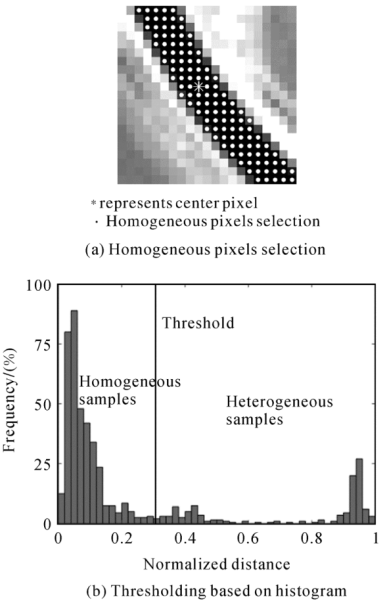

Fig.2
Geographic location of study area and dataset"
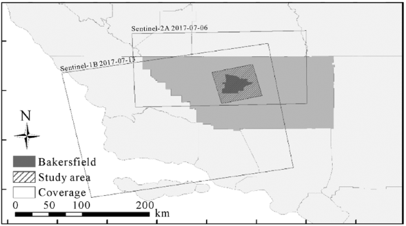

Fig.3
Training sample and validation data(base map: Sentine-2A optical image R,G,B: B4,B3,B2)"
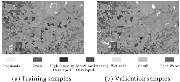
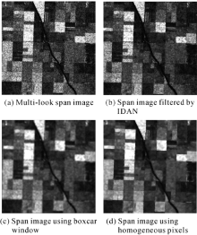
Fig.4
Comparison of smoothed images using two methods"
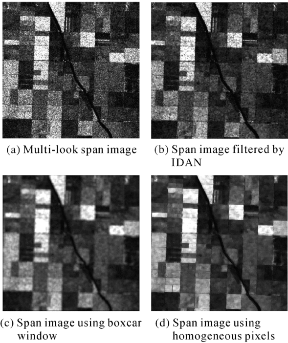
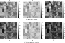
Fig.5
Comparison of polarimetric features extracted using two methods"
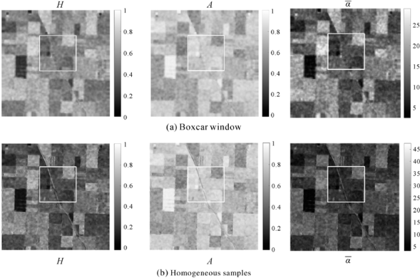
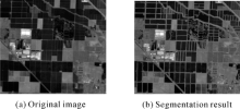
Fig.6
Segmentation results at local scale"

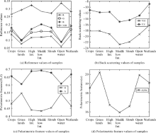
Fig.7
Statistics of all classes samples"

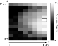
Fig.8
SVM parameter optimization"

Tab.1
Assessment of classification accuracies obtained with two kinds of parameters using object-based classifier"
| Classes | Widely used method | Proposed method | |||
|---|---|---|---|---|---|
| Producer <break/>Accuracy | User <break/>Accuracy | Producer <break/>Accuracy | User <break/>Accuracy | ||
| High-Int./(%) | 100 | 59.1 | 100 | 69.1 | |
| Med&Low Int./(%) | 84.7 | 100 | 85.7 | 100 | |
| Water/(%) | 81.0 | 66.2 | 82.7 | 84.3 | |
| Crops/(%) | 100 | 91.7 | 100 | 93.6 | |
| Grasslands/(%) | 90.1 | 90.1 | 100 | 90.8 | |
| Shrubs/(%) | 88.0 | 100 | 89.1 | 100 | |
| Wetlands/(%) | 79.2 | 100 | 72.9 | 100 | |
| OA/(%) | 90.1 | 92.6 | |||
| Kappa | 0.89 | 0.91 | |||
Tab.2
Assessment of classification accuracies obtained with two kinds of parameters using pixel-based classifier"
| Classes | Widely used method | Proposed method | |||
|---|---|---|---|---|---|
| Producer <break/>Accuracy | User <break/>Accuracy | Producer <break/>Accuracy | User <break/>Accuracy | ||
| High-Int./(%) | 60.2 | 65.2 | 85.3 | 86.2 | |
| Med&Low Int./(%) | 85.3 | 53.4 | 80.5 | 91.3 | |
| Water/(%) | 64.3 | 67.5 | 85.2 | 70.0 | |
| Crops/(%) | 50.4 | 71.1 | 96.3 | 71.6 | |
| Grasslands/(%) | 90.7 | 90.3 | 86.1 | 96.4 | |
| Shrubs/(%) | 50.2 | 80.9 | 50.6 | 90.7 | |
| OA/(%) | 79.8 | 86.6 | |||
| Kappa | 0.74 | 0.84 | |||

Fig.9
Land cover classification maps obtained with different input variables"

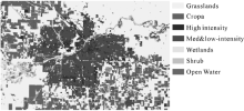
Fig.10
Object-based classification result using refined parameters"

| [1] |
CONGALTON R G, GU Jianyu, YADAV K, et al.Global Land Cover Mapping: A Review and Uncertainty Analysis[J]. Remote Sensing, 2014, 6(12): 12070-12093.
doi: 10.3390/rs61212070 |
| [2] |
DI VITTORIO C A, GEORGAKAKOS A P. Land Cover Classification and Wetland Inundation Mapping Using MODIS[J]. Remote Sensing of Environment, 2018, 204: 1-17.
doi: 10.1016/j.rse.2017.11.001 |
| [3] |
CHEN Jun, CHEN Lijun, LI Ran, et al.Spatial Distribution and Ten Years Change of Global Built-up Areas Derived from GlobeLand30[J]. Acta Geodaetica et Cartographica Sinica, 2015, 44(11): 1181-1188. DOI: 10.11947/j.AGCS.2015.20140677.
doi: 10.11947/j.AGCS.2015.20140677 |
| [4] |
ROSSI C, ERTEN E.Paddy-rice Monitoring Using TanDEM-X[J]. IEEE Transactions on Geoscience and Remote Sensing, 2015, 53(2): 900-910.
doi: 10.1109/TGRS.2014.2330377 |
| [5] |
ZHANG H K, ROY D P.Using the 500 m MODIS Land Cover Product to Derive a Consistent Continental Scale 30m Landsat Land Cover Classification[J]. Remote Sensing of Environment, 2017, 197: 15-34.
doi: 10.1016/j.rse.2017.05.024 |
| [6] | OLIVER C, QUEGAN S.Understanding Synthetic Aperture Radar Images[M]. Boston: SciTech Publishing, 2004. |
| [7] |
DOBSON M C, PIERCE L E, ULABY F T.Knowledge-based Land-cover Classification Using ERS-1/JERS-1 SAR Composites[J]. IEEE Transactions on Geoscience and Remote Sensing, 1996, 34(1): 83-99.
doi: 10.1109/36.481896 |
| [8] |
DU Peijun, SAMAT A, WASKE B, et al.Random Forest and Rotation Forest for Fully Polarized SAR Image Classification Using Polarimetric and Spatial Features[J]. ISPRS Journal of Photogrammetry and Remote Sensing, 2015, 105: 38-53.
doi: 10.1016/j.isprsjprs.2015.03.002 |
| [9] |
UHLMANN S, KIRANYAZ S.Integrating Color Features in Polarimetric SAR Image Classification[J]. IEEE Transactions on Geoscience and Remote Sensing, 2013, 52(4): 2197-2216.
doi: 10.1109/TGRS.2013.2258675 |
| [10] |
GENG Jie, FAN Jianchao, WANG Hongyu, et al.High-resolution SAR Image Classification Via Deep Convolutional Autoencoders[J]. IEEE Geoscience and Remote Sensing Letters, 2015, 12(11): 2351-2355.
doi: 10.1109/LGRS.8859 |
| [11] |
WANG Xinshuang, CHEN Erxue, LI Zengyuan, et al.Multi-temporal and Dual-polarization Interferometric SAR for Land Cover Type Classification[J]. Acta Geodaetica et Cartographica Sinica, 2015, 44(5): 533-540. DOI: 10.11947/j.AGCS.2015.20130244.
doi: 10.11947/j.AGCS.2015.20130244 |
| [12] |
HUANG Xiaodong, WANG Jinfei, SHANG Jiali, et al.Application of Polarization Signature to Land Cover Scattering Mechanism Analysis and Classification Using Multi-temporal C-band Polarimetric RADARSAT-2 Imagery[J]. Remote Sensing of Environment, 2017, 193: 11-28.
doi: 10.1016/j.rse.2017.02.014 |
| [13] |
BLAES X, VANHALLE L, DEFOURNY P.Efficiency of Crop Identification Based on Optical and SAR Image Time Series[J]. Remote Sensing of Environment, 2005, 96(3-4): 352-365.
doi: 10.1016/j.rse.2005.03.010 |
| [14] |
BAGHERI H, SCHMITT M, D’ANGELO P, et al. A Framework for SAR-optical Stereogrammetry over Urban Areas[J]. ISPRS Journal of Photogrammetry and Remote Sensing, 2018, 146: 389-408.
doi: 10.1016/j.isprsjprs.2018.10.003 pmid: 30774219 |
| [15] |
ZHU Zhe, WOODCOCK C E, ROGAN J, et al.Assessment of Spectral, Polarimetric, Temporal, and Spatial Dimensions for Urban and Peri-urban Land Cover Classification Using Landsat and SAR Data[J]. Remote Sensing of Environment, 2012, 117: 72-82.
doi: 10.1016/j.rse.2011.07.020 |
| [16] | LAVRENIUK M, KUSSUL N, MERETSKY M, et al.Impact of SAR Data Filtering on Crop Classification Accuracy[C]∥Proceedings of the 2017 IEEE 1st Ukraine Conference on Electrical and Computer Engineering. Kiev, Ukraine: IEEE, 2017: 912-917. |
| [17] |
JIANG Mi, YONG Bin, TIAN Xin, et al.The Potential of More Accurate InSAR Covariance Matrix Estimation for Land Cover Mapping[J]. ISPRS Journal of Photogrammetry and Remote Sensing, 2017, 126: 120-128.
doi: 10.1016/j.isprsjprs.2017.02.009 |
| [18] |
QIN Fachao, GUO Jiming, LANG Fengkai.Superpixel Segmentation for Polarimetric SAR Imagery Using Local Iterative Clustering[J]. IEEE Geoscience and Remote Sensing Letters, 2015, 12(1): 13-17.
doi: 10.1109/LGRS.2014.2322960 |
| [19] |
TORRES R, SNOEIJ P, GEUDTNER D, et al.GMES Sentinel-1 Mission[J]. Remote Sensing of Environment, 2012, 120: 9-24.
doi: 10.1016/j.rse.2011.05.028 |
| [20] |
ABDIKAN S, SANLI F B, USTUNER M, et al. Land Cover Mapping Using Sentinel-1 SAR Data[J]. The International Archives of the Photogrammetry, Remote Sensing and Spatial Information Sciences, 2016, XLI-B7: 757-761.
doi: 10.1007/s11356-019-05589-x pmid: 31201700 |
| [21] |
VELOSO A, MERMOZ S, BOUVET A, et al.Understanding the Temporal Behavior of Crops Using Sentinel-1 and Sentinel-2-like Data for Agricultural Applications[J]. Remote Sensing of Environment, 2017, 199: 415-426.
doi: 10.1016/j.rse.2017.07.015 |
| [22] |
SUSAKI J, KAJIMOTO M, KISHIMOTO M.Urban Density Mapping of Global Megacities from Polarimetric SAR Images[J]. Remote Sensing of Environment, 2014, 155: 334-348.
doi: 10.1016/j.rse.2014.09.006 |
| [23] |
GENG Xiaomeng, LI Xiaoming, VELOTTO D, et al.Study of the Polarimetric Characteristics of Mud flats in an Intertidal Zone Using C- and X-band Spaceborne SAR Data[J]. Remote Sensing of Environment, 2016, 176: 56-68.
doi: 10.1016/j.rse.2016.01.009 |
| [24] |
WANG Hongquan, MAGAGI R, GOITA K.Comparison of Different Polarimetric Decompositions for Soil Moisture Retrieval over Vegetation Covered Agricultural Area[J]. Remote Sensing of Environment, 2017, 199: 120-136.
doi: 10.1016/j.rse.2017.07.008 |
| [25] | CLOUDE S.The Dual Polarization Entropy/Alpha Decomposition: A PALSAR Case Study[C]∥Proceedings of the 3rd International Workshop on Science and Applications of SAR Polarimetry and Polarimetric Interferometry. Frascati: [s.n.], 2007. |
| [26] |
CLOUDE S R, POTTIER E.An Entropy Based Classification Scheme for Land Applications of Polarimetric SAR[J]. IEEE Transactions on Geoscience and Remote Sensing, 1997, 35(1): 68-78.
doi: 10.1109/36.551935 |
| [27] |
JIANG Mi, DING Xiaoli, HANSSEN R F, et al.Fast Statistically Homogeneous Pixel Selection for Covariance Matrix Estimation for Multitemporal InSAR[J]. IEEE Transactions on Geoscience and Remote Sensing, 2015, 53(3): 1213-1224.
doi: 10.1109/TGRS.2014.2336237 |
| [28] |
VASILE G, TROUVÉ E, LEE J S, et al.Intensity-driven Adaptive-neighborhood Technique for Polarimetric and Interferometric SAR Parameters Estimation[J]. IEEE Transactions on Geoscience and Remote Sensing, 2006, 44(6): 1609-1621.
doi: 10.1109/TGRS.2005.864142 |
| [29] |
VERDOLIVA L, GAETANO R, RUELLO G, et al.Optical-driven Nonlocal SAR Despeckling[J]. IEEE Geoscience and Remote Sensing Letters, 2015, 12(2): 314-318.
doi: 10.1109/LGRS.8859 |
| [30] |
RIDLER T W, CALVARD S.Picture Thresholding Using an Iterative Selection Method[J]. IEEE Transactions on Systems, Man, and Cybernetics, 1978, 8(8): 630-632.
doi: 10.1109/TSMC.1978.4310039 |
| [31] |
GUERBAI Y, CHIBANI Y, HADJADJI B.The Effective Use of the One-class SVM Classifier for Handwritten Signature Verification Based on Writer-independent Parameters[J]. Pattern Recognition, 2015, 48(1): 103-113.
doi: 10.1016/j.patcog.2014.07.016 |
| [32] |
ZHENG Xiulian, YE Hong, TANG Yinggan.Image Bi-level Thresholding Based on Gray Level-local Variance Histogram[J]. Entropy, 2017, 19(5): 191.
doi: 10.3390/e19050191 |
| [33] |
WALTER V.Object-based Classification of Remote Sensing Ddata for Change Detection[J]. ISPRS Journal of Photogrammetry and Remote Sensing, 2004, 58(3-4): 225-238.
doi: 10.1016/j.scitotenv.2019.135295 pmid: 31836216 |
| [34] |
BENZ U C, HOFMANN P, WILLHAUCK G, et al.Multi-resolution, Object-oriented Fuzzy Analysis of Remote Sensing Data for GIS-ready Information[J]. ISPRS Journal of Photogrammetry and Remote Sensing, 2004, 58(3-4): 239-258.
doi: 10.1016/j.isprsjprs.2003.10.002 |
| [35] | FENG Wenqing, SUI Haigang, TU Jihui, et al.Remote Sensing Image Change Detection Based on the Combination of Pixel-level and Object-level Analysis[J]. Acta Geodaetica et Cartographica Sinica, 2017, 46(9): 1147-1155, 1164. DOI: 10.11947/j.AGCS.2017.20160606. |
| [36] | HOMER C G, DEWITZ J, YANG Limin, et al.Completion of the 2011 National Land Cover Database for the Conterminous United States-representing a Decade of Land Cover Change Information[J]. Photogrammetric Engineering and Remote Sensing, 2015, 81(5): 345-354. |
| [37] | TIAN Xin, LIAO Mingsheng.Accurate Extraction of InSAR Temporal Decorrelation Component[J]. Journal of Infrared and Millimeter Waves, 2016, 35(4): 454-461. |
| [38] |
VAPNIK V N.An Overview of Statistical Learning Theory[J]. IEEE Transactions on Neural Networks, 1999, 10(5): 988-999.
doi: 10.1109/72.788640 pmid: 18252602 |
| [39] |
MOUNTRAKIS G, IM J, OGOLE C.Support Vector Machines in Remote Sensing: A Review[J]. ISPRS Journal of Photogrammetry and Remote Sensing, 2011, 66(3): 247-259.
doi: 10.1016/j.isprsjprs.2010.11.001 |
| [1] | Wu ZHU,Yang LEI,Quan SUN. Detection, Estimation and Compensation of Ionospheric Effect on SAR Interferogram Using Azimuth Shift [J]. Journal of Geodesy and Geoinformation Science, 2022, 5(1): 14-24. |
| [2] | Tao ZHANG,Armando MARINO,Ferdinando NUNZIATA,Domenico VELOTTO,Weizeng SHAO,Xiaofeng LI,Maurizio MIGLIACCIO,Huilin XIONG. Marine Target Detection Using Dual-polarimetric SAR Imagery [J]. Journal of Geodesy and Geoinformation Science, 2021, 4(1): 63-69. |
| [3] | Yingxia CHEN,Yan CHEN,Cong LIU. Joint AIHS and Particle Swarm Optimization for Pan-sharpening [J]. Journal of Geodesy and Geoinformation Science, 2020, 3(2): 105-113. |
| [4] | Jianjun ZHU,Qinghua XIE,Tingying ZUO,Changcheng WANG,Jian XIE. Complex Least Squares Adjustment to Improve Tree Height Inversion Problem in PolInSAR [J]. Journal of Geodesy and Geoinformation Science, 2019, 2(1): 1-8. |
| Viewed | ||||||
|
Full text |
|
|||||
|
Abstract |
|
|||||