
Journal of Geodesy and Geoinformation Science ›› 2021, Vol. 4 ›› Issue (1): 124-143.doi: 10.11947/j.JGGS.2021.0115
• Special Issue • Previous Articles Next Articles
Qing ZHAO1,2,3( ),Antonio PEPE4,Adam DEVLIN5,6,Shuangshang ZHANG7,Francesco FALABELLA4,8,Giovanni ZENI4,Qiang WANG1,2,3,Jingzhao DING1,2,3,Danan DONG1,2,Min LIU1,2,3,Qing XU7,Xia LEI6,Jiayi PAN5,6()
Received:2020-10-10
Accepted:2020-12-25
Online:2021-03-20
Published:2021-04-06
Contact:
Jiayi PAN
E-mail:qzhao@geo.ecnu.edu.cn;panj@cuhk.edu.hk
About author:Qing ZHAO (1982-), female, associate professor, majors in satellite remote sensing and its applications. E-mail: Supported by:Qing ZHAO,Antonio PEPE,Adam DEVLIN,Shuangshang ZHANG,Francesco FALABELLA,Giovanni ZENI,Qiang WANG,Jingzhao DING,Danan DONG,Min LIU,Qing XU,Xia LEI,Jiayi PAN. Impact of Sea-Level-Rise and Human Activities in Coastal Regions: An Overview[J]. Journal of Geodesy and Geoinformation Science, 2021, 4(1): 124-143.
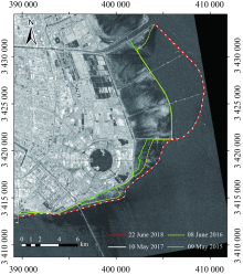
Fig.1
Mapping of the extracted shorelines of Nanhui New City of Shanghai from 2015 to 2018 as obtained from Sentinel-1A SAR images"

Tab.1
The open access DEM data sources"
| ASTER GDEM | SRTM DEM | GTOPO30 | GMTED2010 | |
|---|---|---|---|---|
| Instruments | The Advanced Spaceborne Thermal Emission and Reflection Radiometer (ASTER) onboard NASA’s Terra spacecraft | C-band and X-band Synthetic Aperture Radars onboard NASA’s space shuttle Endeavour | Fusion of eight data sources | Fusion of 11 raster-based elevation sources. The primary source dataset is SRTM DEM of NGA. |
| Data collection time | 2000—2008 (Version 1) 2000—2010 (Version 2) | 2000 | 1996 | 2010 |
| Resolution | 30m 20m | 30m (in the US) 90m (in the rest of the world) | 1km | 250m 500 m 1km |
| Vertical accuracy | 20m (Version 1) 13 m with controversy (Version 2) | 16m | 30m | 28m 31m 34m |
| Coverage | 83 degrees north—83 degrees south | 60 degrees north—56 degrees south | The entire global land surface | Global coverage of all land areas |
| Advantages | It provides the global current elevation data with a relatively higher resolution. | It covers most of the global land surface with relatively higher resolution. | It covers the entire global land surface | It provides the global current elevation data. |
| Disadvantages | ASTER GDEM is severely affected by random noise and anomalies | The previously released SRTM DEM-3 v4.1 is limited by 90m resolution and inaccurate void-filling. | Coarse resolution to satisfy the demands of coastal inundation mapping and assessment | Coarse resolution to satisfy the demands of coastal inundation mapping and assessment |

Fig.2
DEMs of Nanhui New City obtained with bistatic interferometry"
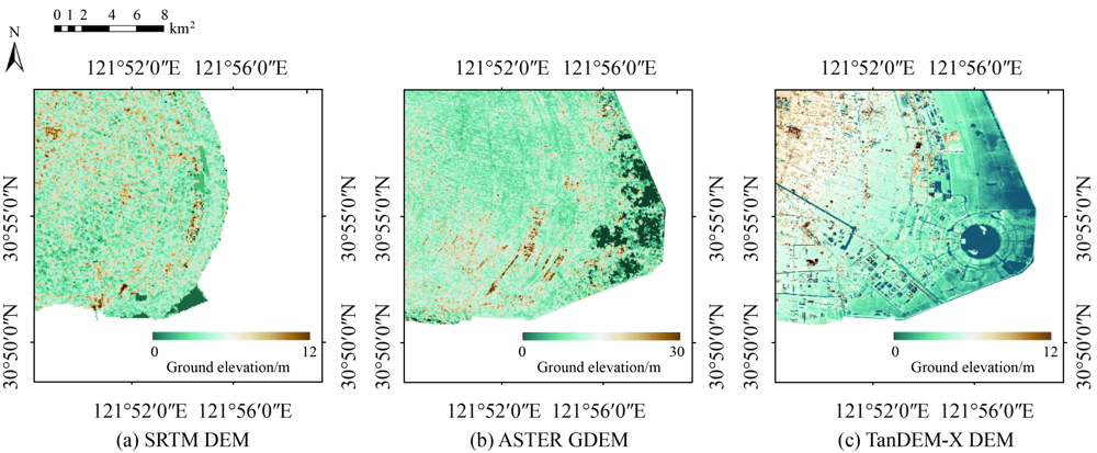

Fig.3
InSAR geometry"
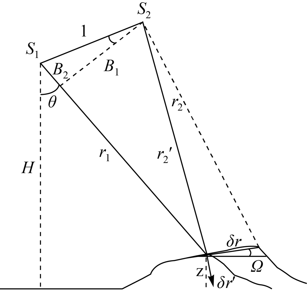
Fig.4
Ground displacement map of the coastal area of Shanghai. The maps are overimposed to a geolocalized CSK SAR amplitude image of the investigated area"

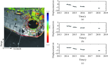
Fig.5
Map of the mean displacement rate of the Lingang New City from 2014 to 2018, as revealed by the CSK SAR constellation. Plots of deformation time-series of three selected points, labelled to as (a), (b), (c) are also shown"

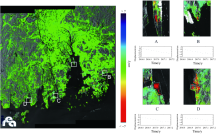
Fig.6
Map of mean displacement rate of the PRE region from September 2016 to March 2017, as revealed by processing a set of Sentinel-1 SAR data. Four regions, labeled to as A,B,C,D, characterized by significant deformations rates are highlighted. Plots of the surface deformation time-series in correspondence to four selected pixels in the highlighted zones are also shown"
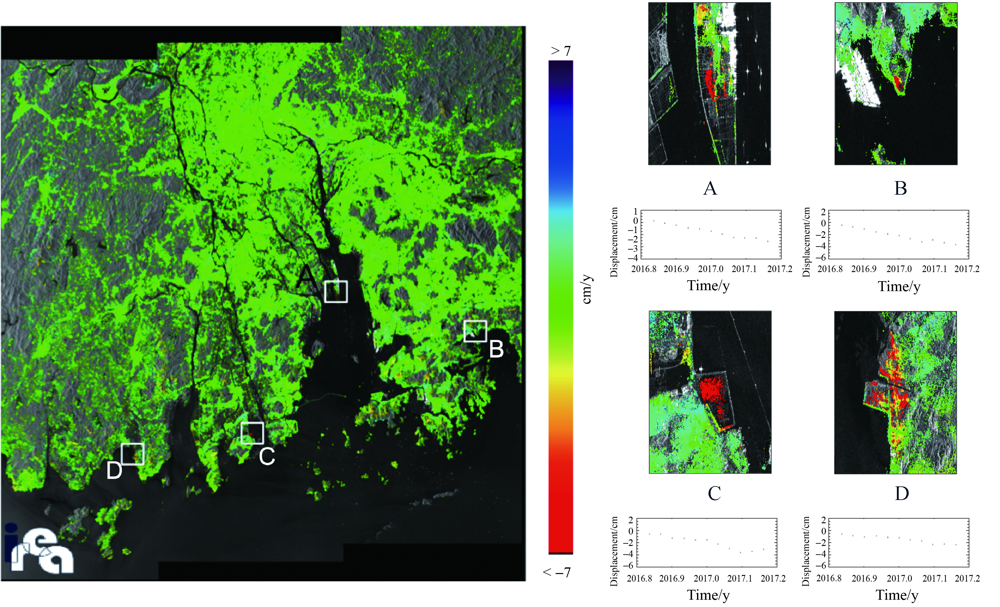
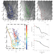
Fig.7
Three Sentinel-1A SAR images over Subei Bank acquired at different tidal levels: (a) low tidal level at 21:57 UTC on 2 Jun. 2015; (b) middle tidal level at 09:54 UTC on 18 Sep. 2015; (c) high tidal level at 09:54 UTC on 26 Feb. 2015. The color lines are the extracted waterlines from the SAR images. (d) SAR derived elevations using the waterline method. Comparison of SAR derived elevations (colored dots) and in-situ observations (black dots) along the two transects: JD32 (e) and JD34 (f). The distance is measured from the left to the right for each transect"
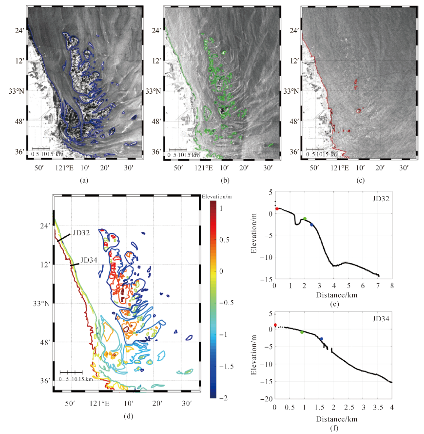
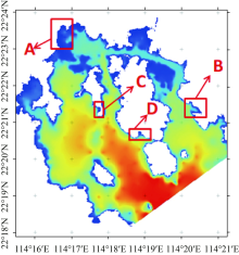
Fig.8
Test sites (A, B, C, D) in the Port Shelter of the Hong Kong coastal water"

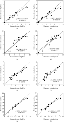
Fig.9
Satellite image-retrieved water depth versus in-situ observation data. The dash lines represent 1:1 lines"
Tab.2
Accuracy of water depth retrieval from high resolution satellite imagers"
| Area A | Area B | Area C | Area D | |||||
|---|---|---|---|---|---|---|---|---|
| Water depth range/m | 0~5.5 | 0~10.7 | 0~7.3 | 0~1.7 | ||||
| Band type | Blue | Green | Blue | Green | Blue | Green | Blue | Green |
| Absolute error /m | 0.36 | 0.39 | 0.86 | 0.81 | 0.49 | 0.50 | 0.06 | 0.07 |
| Relative error /(%) | 18.5 | 18.8 | 19.0 | 19.2 | 17.5 | 18.9 | 9.9 | 15.2 |
| [1] |
NICHOLLS R J, CAZENAVE A. Sea-level rise and its impact on coastal zones[J]. Science, 2010,328(5985):1517-1520.
doi: 10.1126/science.1185782 pmid: 20558707 |
| [2] |
WOODRUFF J D, IRISH J L, CAMARGO S J. Coastal flooding by tropical cyclones and sea-level rise[J]. Nature, 2013,504(7478):44-52.
doi: 10.1038/nature12855 pmid: 24305147 |
| [3] | CHENG H, CHEN J Y, CHEN Z J, et al. Mapping sea level rise behavior in an Estuarine Delta System: a case study along the Shanghai coast[J]. Engineering, 2018,4(1):156-163. |
| [4] | STOCKAMP J, BISHOP P, LI Z H, et al. State-of-the-art in studies of glacial isostatic adjustment for the British Isles: a literature review[J]. Earth and Environmental Science Transactions of the Royal Society of Edinburgh, 2015,106(3):145-170. |
| [5] | BENTLEY SR S J, BLUM M D, MALONEY J, et al. The Mississippi River source-to-sink system: perspectives on tectonic, climatic, and anthropogenic influences, Miocene to Anthropocene[J]. Earth-Science Reviews, 2016,153:139-174. |
| [6] | HIGGINS S A. Review: advances in delta-subsidence research using satellite methods[J]. Hydrogeology Journal, 2016,24(3):587-600. |
| [7] | SIMMS A, REYNOLDS L C, BENTZ M, et al. Tectonic subsidence of California estuaries increases forecasts of relative sea-level rise[J]. Estuaries and Coasts, 2016,39(6):1571-1581. |
| [8] | INGEBRITSEN S E, IKEHARA M E, GALLOWAY D L, et al. Delta subsidence in California: the sinking heart of the state[M]. Reston: US Geological Survey, 2000. |
| [9] | YANG S L, MILLIMAN J D, LI P, et al. 50,000 dams later: erosion of the Yangtze River and its delta[J]. Global and Planetary Change, 2011,75(1-2):14-20. |
| [10] | CHEN J Y, KNIGHT R, ZEBKER H A, et al. Confined aquifer head measurements and storage properties in the San Luis Valley, Colorado, from spaceborne InSAR observations[J]. Water Resources Research, 2016,52(5):3623-3636. |
| [11] | ZHAO Q, PEPE A, GAO W, et al. A DInSAR investigation of the ground settlement time evolution of ocean-reclaimed lands in Shanghai[J]. IEEE Journal of Selected Topics in Applied Earth Observations and Remote Sensing, 2015,8(4):1763-1781. |
| [12] | XU Bing, FENG Guangcai, LI Zhiwei, et al. Coastal subsidence monitoring associated with land reclamation using the point target based SBAS-InSAR Method: A case study of Shenzhen, China[J]. Remote Sensing, 2016,8(8):652. |
| [13] | PEPE A, BONANO M, ZHAO Qing, et al. The joint use of multiple satellite SAR data and geotechnical models for the study of the Shanghai Ocean-reclaimed lands[J]. Remote Sensing, 2016,8:911. |
| [14] | TIAN Bo, WU Wenting, YANG Zhaoqing, et al. Drivers, trends, and potential impacts of long-term coastal reclamation in China from 1985 to 2010[J]. Estuarine, Coastal and Shelf Science, 2016,170:83-90. |
| [15] | ZHANG Wei, RUAN Xiaohong, ZHENG Jinhai, et al. Long-term change in tidal dynamics and its cause in the Pearl River Delta, China[J]. Geomorphology, 2010,120(3-4):209-223. |
| [16] | WANG Hua, WRIGHT T J, YU Yongping, et al. InSAR reveals coastal subsidence in the Pearl River Delta, China[J]. Geophysical Journal International, 2012,191(3):1119-1128. |
| [17] | CHEN F, LIN H, ZHANG Y, et al. Ground subsidence geo-hazards induced by rapid urbanization: implications from InSAR observation and geological analysis[J]. Natural Hazards and Earth System Sciences, 2012,12(4):935-942. |
| [18] | DEVLIN A T, PAN Jiayi, LIN Hui. Extended spectral analysis of tidal variability in the North Atlantic Ocean[J]. Journal of Geophysical Research: Oceans, 2019,124(1):506-526. |
| [19] | DEVLIN A T, PAN Jiayi, LIN Hui. Tidal variability in the Hong Kong region[J]. Ocean Science, 2019,15(4):853-864. |
| [20] |
DAI Zhijun, LIU J T, WEI Wen, et al. Detection of the Three Gorges Dam influence on the Changjiang (Yangtze River) submerged delta[J]. Scientific Reports, 2014,4:6600.
doi: 10.1038/srep06600 pmid: 25321660 |
| [21] | WEI Wen, TANG Zhenghong, DAI Zhijun, et al. Variations in tidal flats of the Changjiang (Yangtze) estuary during 1950s—2010s: future crisis and policy implication[J]. Ocean & Coastal Management, 2015,108:89-96. |
| [22] | DUAN Huabo, ZHANG Hui, HUANG Qifei, et al. Characterization and environmental impact analysis of sea land reclamation activities in China[J]. Ocean & Coastal Management, 2016,130:128-137. |
| [23] | WU Chuangshou, YANG Shilun, HUANG Shichang, et al. Delta changes in the Pearl River estuary and its response to human activities (1954-2008)[J]. Quaternary International, 2016,392:147-154. |
| [24] | ZHU M S, SUN T, SHAO D D. Impact of land reclamation on the evolution of shoreline change and nearshore vegetation distribution in Yangtze River estuary[J]. Wetlands, 2016,36(1):11-17. |
| [25] | ZHANG Wei, XU Yang, HOITINK A J F, et al. Morphological change in the Pearl River Delta, China[J]. Marine Geology, 2015,363:202-219. |
| [26] | WU Ziyin, MILLIMAN J D, ZHAO Dineng, et al. Geomorphologic changes in the lower Pearl River Delta, 1850-2015, largely due to human activity[J]. Geomorphology, 2018,314:42-54. |
| [27] | ZHU Lei, HE Qing, SHEN Jian, et al. The influence of human activities on morphodynamics and alteration of sediment source and sink in the Changjiang Estuary[J]. Geomorphology, 2016,273:52-62. |
| [28] | MEI Xuefei, DAI Zhijun, WEI Wen, et al. Secular bathymetric variations of the North Channel in the Changjiang (Yangtze) Estuary, China, 1880-2013: Causes and effects[J]. Geomorphology, 2018,303:30-40. |
| [29] | WEI Wen, MEI Xuefei, DAI Zhijun, et al. Recent morphodynamic evolution of the largest uninhibited island in the Yangtze (Changjiang) estuary during 1998-2014: influence of the anthropogenic interference[J]. Continental Shelf Research, 2016,124:83-94. |
| [30] | JIANG Chenjuan, LI Jiufa, DE SWART H E. Effects of navigational works on morphological changes in the bar area of the Yangtze Estuary[J]. Geomorphology, 2012, 139-140:205-219. |
| [31] | PAN Lingzhi, GE Jiangzhong. Analysis of the influence of Deep Waterway Project on morphological evolution in the North Passage of the Changjiang Estuary, China[C]// Proceedings of 2011 International Conference on Remote Sensing, Environment and Transportation Engineering. Nanjing: IEEE, 2011: 1957-1963. |
| [32] | YANG S L, BELKIN I M, BELKINA A I, et al. Delta response to decline in sediment supply from the Yangtze River: evidence of the recent four decades and expectations for the next half-century[J]. Estuarine, Coastal and Shelf Science, 2003,57(4):689-699. |
| [33] | LUAN Hualong, DING Pingxing, WANG Zhengbing, et al. Decadal morphological evolution of the Yangtze Estuary in response to river input changes and estuarine engineering projects[J]. Geomorphology, 2016,265:12-23. |
| [34] | MASSONNET D, FEIGL K L. Radar interferometry and its application to changes in the Earth’s surface[J]. Reviews of Geophysics, 1998,36(4):441-500. |
| [35] | FERRETTI A, PRATI C, ROCCA F. Permanent scatterers in SAR interferometry[J]. IEEE Transactions on Geoscience and Remote Sensing, 2001,39(1):8-20. |
| [36] | HOOPER A, ZEBKER H, SEGALL P, et al. A new method for measuring deformation on volcanoes and other natural terrains using InSAR persistent scatterers[J]. Geophysical Research Letters, 2004,31(23):L23611. |
| [37] | BERARDINO P, FORNARO G, LANARI R, et al. A new algorithm for surface deformation monitoring based on small baseline differential SAR interferograms[J]. IEEE Transactions on Geoscience and Remote Sensing, 2002,40(11):2375-2383. |
| [38] | MORA O, MALLORQUI J J, BROQUETAS A. Linear and nonlinear terrain deformation maps from a reduced set of interferometric SAR images[J]. IEEE Transactions on Geoscience and Remote Sensing, 2003,41(10):2243-2253. |
| [39] | COVELLO F, BATTAZZA F, COLETTA A, et al. COSMO-SkyMed an existing opportunity for observing the Earth[J]. Journal of Geodynamics, 2010,49(3-4):171-180. |
| [40] | TORRES R, SNOEIJ P, GEUDTNER D, et al. GMES Sentinel-1 mission[J]. Remote Sensing of Environment, 2012,120:9-24. |
| [41] | WANG Wei, LIU Hui, LI Yongqi, et al. Development and management of land reclamation in China[J]. Ocean & Coastal Management, 2014,102:415-425. |
| [42] |
ZHAO Qing, LIN Hui, JIANG Liming, et al. A study of ground deformation in the Guangzhou Urban Area with Persistent Scatterer Interferometry[J]. Sensors, 2009,9(1):503-518.
doi: 10.3390/s90100503 pmid: 22389613 |
| [43] | WANG Xina, WANG Xianwei, ZHAI Jianqing, et al. Improvement to flooding risk assessment of storm surges by residual interpolation in the coastal areas of Guangdong Province, China[J]. Quaternary International, 2017,453:1-14. |
| [44] | CHAN F K S, ADEKOLA O A, MITCHELL G, et al. Appraising sustainable flood risk management in the Pearl River Delta’s coastal megacities: a case study of Hong Kong, China[J]. Journal of Water and Climate Change, 2013,4(4):390-409. |
| [45] |
CHURCH J A, WHITE N J. Sea-level rise from the Late 19th to the Early 21st century[J]. Surveys in Geophysics, 2011,32(4):585-602.
doi: 10.1007/s10712-011-9119-1 |
| [46] | CHURCH J A, WHITE N J. A 20th century acceleration in global sea-level rise[J]. Geophysical Research Letters, 2006,33(1):L01602. |
| [47] | NEREM R S, CHAMBERS D P, CHOE C, et al. Estimating mean sea level change from the TOPEX and jason altimeter missions[J]. Marine Geodesy, 2010,33(S1):435-446. |
| [48] |
MERRIFIELD M A, MERRIFIELD S T, MITCHUM G T. An anomalous recent acceleration of global sea level rise[J]. Journal of Climate, 2009,22(21):5772-5781.
doi: 10.1175/2009JCLI2985.1 |
| [49] |
MERRIFIELD M A. A shift in western tropical Pacific sea level trends during the 1990s[J]. Journal of Climate, 2011,24(15):4126-4138.
doi: 10.1175/2011JCLI3932.1 |
| [50] |
DOMINGUES C M, CHURCH J A, WHITE N J, et al. Improved estimates of upper-ocean warming and multi-decadal sea-level rise[J]. Nature, 2008,453(7198):1090-1093.
doi: 10.1038/nature07080 pmid: 18563162 |
| [51] | SLANGEN A B A, CHURCH J A, AGOSTA C, et al. Anthropogenic forcing dominates global mean sea-level rise since 1970[J]. Nature Climate Change, 2016,6(7):701-705. |
| [52] |
KÖHL A, STAMMER D, CORNUELLE B. Interannual to decadal changes in the ECCO global synjournal[J]. Journal of Physical Oceanography, 2007,37(2):313-337.
doi: 10.1175/JPO3014.1 |
| [53] | JAY D A. Evolution of tidal amplitudes in the eastern Pacific Ocean[J]. Geophysical Research Letters, 2009,36(4):L04603. |
| [54] |
RAY R D, FOSTER G. Future nuisance flooding at Boston caused by astronomical tides alone[J]. Earth’s Future, 2016,4(12):578-587.
doi: 10.1002/2016EF000423 |
| [55] |
RAY R D. Secular changes of the M2 tide in the Gulf of Maine[J]. Continental Shelf Research, 2006,26(3):422-427.
doi: 10.1016/j.csr.2005.12.005 |
| [56] |
RAY R D. Secular changes in the solar semidiurnal tide of the western North Atlantic Ocean[J]. Geophysical Research Letters, 2009,36(19):L19601.
doi: 10.1029/2009GL040217 |
| [57] |
FENG Xiangbo, TSIMPLIS M N, WOODWORTH P L. Nodal variations and long-term changes in the main tides on the coasts of China[J]. Journal of Geophysical Research: Oceans, 2015,120(2):1215-1232.
doi: 10.1002/2014JC010312 |
| [58] |
MOFTAKHARI H R, AGHAKOUCHAK A, SANDERS B F, et al. Cumulative hazard: the case of nuisance flooding[J]. Earths Future, 2017,5(2):214-223.
doi: 10.1002/eft2.2017.5.issue-2 |
| [59] |
MOFTAKHARI H R, AGHAKOUCHAK A, SANDERS B F, et al. Increased nuisance flooding along the coasts of the United States due to sea level rise: past and future[J]. Geophysical Research Letters, 2015,42(22):9846-9852.
doi: 10.1002/2015GL066072 |
| [60] |
FAMILKHALILI R, TALKE S A. The effect of channel deepening on tides and storm surge: a case study of Wilmington, NC[J]. Geophysical Research Letters, 2016,43(17):9138-9147.
doi: 10.1002/2016GL069494 |
| [61] |
ARNS A, DANGENDORF S, JENSEN J, et al. Sea-level rise induced amplification of coastal protection design heights[J]. Scientific Reports, 2017,7:40171.
doi: 10.1038/srep40171 pmid: 28057920 |
| [62] |
SWEET W V, PARK J. From the extreme to the mean: acceleration and tipping points of coastal inundation from sea level rise[J]. Earth’s Future, 2014,2(12):579-600.
doi: 10.1002/eft2.2014.2.issue-12 |
| [63] | MEI-E R. Relative sea-level changes in China over the last 80 years[J]. Journal of Coastal Research, 1993,9(1):229-241. |
| [64] |
HE Lei, LI Guosheng, LI Kuo, et al. Estimation of regional sea level change in the Pearl River Delta from tide gauge and satellite altimetry data[J]. Estuarine, Coastal and Shelf Science, 2014,141:69-77.
doi: 10.1016/j.ecss.2014.02.005 |
| [65] |
KANG Yanyan, DING Xianrong, XU Fan, et al. Topographic mapping on large-scale tidal flats with an iterative approach on the waterline method[J]. Estuarine, Coastal and Shelf Science, 2017,190:11-22.
doi: 10.1016/j.ecss.2017.03.024 |
| [66] | LI K, MOK H. Long term trends of the regional sea level changes in Hong Kong and the adjacent waters[C]// The 6th International Conference on Asian and Pacific Coasts. Hong Kong, China: HKO, 2012: 349-359. |
| [67] |
LEE J S, JURKEVICH I. Coastline detection and tracing in SAR images[J]. IEEE Transactions on Geoscience and Remote Sensing, 1990,28(4):662-668.
doi: 10.1109/TGRS.1990.572976 |
| [68] |
WANG Qiushun, PAN Cunhong, ZHANG Guangzhi. Impact of and adaptation strategies for sea-level rise on Yangtze River Delta[J]. Advances in Climate Change Research, 2018,9(2):154-160.
doi: 10.1016/j.accre.2018.05.005 |
| [69] |
DING Xianwen, LI Xiaofeng. Shoreline movement monitoring based on SAR images in Shanghai, China[J]. International Journal of Remote Sensing, 2014,35(11-12):3994-4008.
doi: 10.1080/01431161.2014.916480 |
| [70] | BOAK E H, TURNER I L. Shoreline definition and detection: a review[J]. Journal of Coastal Research, 2005,21(4):688-703. |
| [71] |
PARDO-PASCUAL J E, SáNCHEZ-GARCíA E, ALMONACID-CABALLER J, et al. Assessing the accuracy of automatically extracted shorelines on microtidal beaches from Landsat 7, Landsat 8 and Sentinel-2 imagery[J]. Remote Sensing, 2018,10(2):326.
doi: 10.3390/rs10020326 |
| [72] |
VAN DER WERFF H M A. Mapping shoreline indicators on a sandy beach with supervised edge detection of soil moisture differences[J]. International Journal of Applied Earth Observation and Geoinformation, 2019,74:231-238.
doi: 10.1016/j.jag.2018.09.007 |
| [73] |
LEE J S. Speckle analysis and smoothing of synthetic aperture radar images[J]. Computer Graphics and Image Processing, 1981,17(1):24-32.
doi: 10.1016/S0146-664X(81)80005-6 |
| [74] |
AL FUGURA A, BILLA L, PRADHAN B. Semi-automated procedures for shoreline extraction using single RADARSAT-1 SAR image[J]. Estuarine, Coastal and Shelf Science, 2011,95(4):395-400.
doi: 10.1016/j.ecss.2011.10.009 |
| [75] |
FREEMAN A. SAR calibration: an overview[J]. IEEE Transactions on Geoscience and Remote Sensing, 1992,30(6):1107-1121.
doi: 10.1109/36.193786 |
| [76] |
DELLEPIANE S, DE LAURENTIIS R, GIORDANO F. Coastline extraction from SAR images and a method for the evaluation of the coastline precision[J]. Pattern Recognition Letters, 2004,25(13):1461-1470.
doi: 10.1016/j.patrec.2004.05.022 |
| [77] |
BASELICE F, FERRAIOLI G. Unsupervised coastal line extraction from SAR images[J]. IEEE Geoscience and Remote Sensing Letters, 2013,10(6):1350-1354.
doi: 10.1109/LGRS.2013.2241013 |
| [78] | JARVIS A, REUTER H I, NELSON A, et al. Hole-filled SRTM for the globe Version 4 [EB/OL]. https://cgiarcsi.community/data/srtm-90m-digital-elevation-database-v4-1/ |
| [79] |
MUKHERJEE S, JOSHI P K, MUKHERJEE S, et al. Evaluation of vertical accuracy of open source Digital Elevation Model (DEM)[J]. International Journal of Applied Earth Observation and Geoinformation, 2013,21:205-217.
doi: 10.1016/j.jag.2012.09.004 |
| [80] | TACHIKAWA T, HATO M, KAKU M, et al. Characteristics of ASTER GDEM version 2[C]// Proceedings of 2011 IEEE International Geoscience and Remote Sensing Symposium. Vancouver: IEEE, 2011: 3657-3660. |
| [81] | TACHIKAWA T, KAKU M, IWASAKI A, et al. ASTER global digital elevation model version 2-summary of validation results[R]. [S.l.]: NASA, 2011. |
| [82] | GESCH D B. The effects of DEM generalization methods on derived hydrologic features[R]. Chelsea: CRC Press, 1999: 255-262. |
| [83] | DANIELSON J J, GESCH D B. Global multi-resolution terrain elevation data 2010 (GMTED2010)[R]. [S.l.]: US Department of the Interior, US Geological Survey, 2011. |
| [84] |
KRIEGER G, MOREIRA A, FIEDLER H, et al. TanDEM-X: a satellite formation for high-resolution SAR interferometry[J]. IEEE Transactions on Geoscience and Remote Sensing, 2007,45(11):3317-3341.
doi: 10.1109/TGRS.2007.900693 |
| [85] | WEIGT M, RIZZOLI P, BACHMANN M, et al. TanDEM-X Mission-Interferometric Performance and Global DEM Acquisition Status[C]// IET International Conference on Radar Systems. Glasgow: IEEE, 2012. |
| [86] | FRANCESCHETTI G, LANARI R. Synthetic aperture radar processing[M]. Boca Raton: CRC Press, 1999. |
| [87] |
PEPE A, CALò F. A review of interferometric synthetic aperture RADAR (InSAR) multi-track approaches for the retrieval of Earth’s surface displacements[J]. Applied Sciences, 2017,7(12):1264.
doi: 10.3390/app7121264 |
| [88] | STRANG G. Linear algebra and its applications[M]. Orlando, FL: Harcourt Brace Jovanovich, 1988. |
| [89] |
FERRETTI A, FUMAGALLI A, NOVALI F, et al. A new algorithm for processing interferometric data-stacks: SqueeSAR[J]. IEEE Transactions on Geoscience and Remote Sensing, 2011,49(9):3460-3470.
doi: 10.1109/TGRS.2011.2124465 |
| [90] |
PEPE A, LANARI R. On the extension of the minimum cost flow algorithm for phase unwrapping of multitemporal differential SAR interferograms[J]. IEEE Transactions on Geoscience and Remote Sensing, 2006,44(9):2374-2383.
doi: 10.1109/TGRS.2006.873207 |
| [91] |
LANARI R, MORA O, MANUNTA M, et al. A small-baseline approach for investigating deformations on full-resolution differential SAR interferograms[J]. IEEE Transactions on Geoscience and Remote Sensing, 2004,42(7):1377-1386.
doi: 10.1109/TGRS.2004.828196 |
| [92] | FALABELLA F, PEPE A, ZHAO Qing, et al. A hybrid multi-scale InSAR approach to study the 2014-2018 Surface Deformation of the Shanghai Coastal Region through Sequences of Time-Gapped Cosmo-SkyMed SAR acquisitions[R]. Xi’an, China: ESA-MOST Dragon IV Mid-term Symposium, 2018. |
| [93] |
DENG Xiangzheng, HUANG Jikun, ROZELLE S, et al. Growth, population and industrialization, and urban land expansion of China[J]. Journal of Urban Economics, 2008,63(1):96-115.
doi: 10.1016/j.jue.2006.12.006 |
| [94] |
CHAN C K, YAO Xiaohong. Air pollution in mega cities in China[J]. Atmospheric Environment, 2008,42(1):1-42.
doi: 10.1016/j.atmosenv.2007.09.003 |
| [95] |
GONG P, LIANG S, CARLTON E J, et al. Urbanisation and health in China[J]. The Lancet, 2012,379(9818):843-852.
doi: 10.1016/S0140-6736(11)61878-3 |
| [96] |
DE LOOR G. The observation of tidal patterns, currents, and bathymetry with SLAR imagery of the sea[J]. IEEE Journal of Oceanic Engineering, 1981,6(4):124-129.
doi: 10.1109/JOE.1981.1145501 |
| [97] | ALPERS W, HENNINGS I. A theory of the imaging mechanism of underwater bottom topography by real and synthetic aperture radar[J]. Journal of Geophysical Research: Oceans, 1984,89(C6):10529-10546. |
| [98] |
CALKOEN C J, HESSELMANS G H F M, WENSINK G J, et al. The bathymetry assessment system: efficient depth mapping in shallow seas using radar images[J]. International Journal of Remote Sensing, 2001,22(15):2973-2998.
doi: 10.1080/01431160116928 |
| [99] | HUANG Weigen, FU Bin. A spaceborne SAR technique for shallow water bathymetry surveys[J]. Journal of Coastal Research, 2004,(43):223-228. |
| [100] |
FAN Kaiguo, HUANG Weigen, LIN Hui, et al. Shallow water depth retrieval from space-borne SAR imagery[J]. Journal of Oceanography, 2011,67(4):405-413.
doi: 10.1007/s10872-011-0037-0 |
| [101] |
RENGA A, RUFINO G, D’ERRICO M, et al. SAR bathymetry in the Tyrrhenian Sea by COSMO-SkyMed data: a novel approach[J]. IEEE Journal of Selected Topics in Applied Earth Observations and Remote Sensing, 2014,7(7):2834-2847.
doi: 10.1109/JSTARS.2014.2327150 |
| [102] |
STEWART C, RENGA A, GAFFNEY V, et al. Sentinel-1 bathymetry for North Sea palaeolandscape analysis[J]. International Journal of Remote Sensing, 2016,37(3):471-491.
doi: 10.1080/01431161.2015.1129563 |
| [103] |
BIAN Xiaolin, SHAO Yun, TIAN Wei, et al. Underwater topography detection in coastal areas using fully polarimetric SAR data[J]. Remote Sensing, 2017,9(6):560.
doi: 10.3390/rs9060560 |
| [104] | WACKERMAN C, LYZENGA D, ERICSON E, et al. Estimating near-shore bathymetry using SAR[C]// Proceedings of IGARSS’98. Sensing and Managing the Environment. 1998 IEEE International Geoscience and Remote Sensing. Seattle: IEEE, 1998: 1668-1670. |
| [105] |
BRUSCH S, HELD P, LEHNER S, et al. Underwater bottom topography in coastal areas from TerraSAR-X data[J]. International Journal of Remote Sensing, 2011,32(16):4527-4543.
doi: 10.1080/01431161.2010.489063 |
| [106] |
MISHRA M K, GANGULY D, CHAUHAN P, et al. Estimation of coastal bathymetry using RISAT-1 C-band microwave SAR data[J]. IEEE Geoscience and Remote Sensing Letters, 2014,11(3):671-675.
doi: 10.1109/LGRS.2013.2274475 |
| [107] |
BOCCIA V, RENGA A, RUFINO G, et al. Linear dispersion relation and depth sensitivity to swell parameters: application to synthetic aperture radar imaging and bathymetry[J]. The Scientific World Journal, 2015,2015:374579.
doi: 10.1155/2015/374579 pmid: 25789333 |
| [108] |
BIAN Xiaolin, SHAO Yun, WANG Shiang, et al. Shallow water depth retrieval from multitemporal Sentinel-1 SAR data[J]. IEEE Journal of Selected Topics in Applied Earth Observations and Remote Sensing, 2018,11(9):2991-3000.
doi: 10.1109/JSTARS.4609443 |
| [109] |
MASON D C, SCOTT T R, DANCE S L. Remote sensing of intertidal morphological change in Morecambe Bay, U.K., between 1991 and 2007[J]. Estuarine, Coastal and Shelf Science, 2010,87(3):487-496.
doi: 10.1016/j.ecss.2010.01.015 |
| [110] |
RYU J H, WON J S, MIN K D. Waterline extraction from Landsat TM data in a tidal flat: a case study in Gomso Bay, Korea[J]. Remote sensing of Environment, 2002,83(3):442-456.
doi: 10.1016/S0034-4257(02)00059-7 |
| [111] | POLCYN F C, BROWN W L, SATTINGER I J. The measurement of water depth by remote sensing techniques[R]. Washington: Naval Oceanographic Office, 1970. |
| [112] |
LYZENGA D R. Passive remote sensing techniques for mapping water depth and bottom features[J]. Applied Optics, 1978,17(3):379-383.
doi: 10.1364/AO.17.000379 pmid: 20174418 |
| [113] |
LEE Z, CARDER K L, MOBLEY C D, et al. Hyperspectral remote sensing for shallow waters. I. A semianalytical model[J]. Applied Optics, 1998,37(27):6329-6338.
doi: 10.1364/ao.37.006329 pmid: 18286131 |
| [114] |
GEYMAN E C, MALOOF A C. A simple method for extracting water depth from multispectral satellite imagery in regions of variable bottom type[J]. Earth and Space Science, 2019,6(3):527-537.
doi: 10.1029/2018EA000539 |
| [115] | ADLER-GOLDEN S M, BERK A, BERNSTEIN L S, et al. FLAASH, a MODTRAN4 atmospheric correction package for hyperspectral data retrievals and simulations[C]// Proceedings of 7th Annual JPL Airborne Earth Science Workshop. California: JPL Publication, 1998: 9-14. |
| [116] |
BATES P D, DE ROO A P J. A simple raster-based model for flood inundation simulation[J]. Journal of Hydrology, 2000,236(1-2):54-77.
doi: 10.1016/S0022-1694(00)00278-X |
| [117] |
BATES P D, DAWSON R J, HALL J W, et al. Simplified two-dimensional numerical modelling of coastal flooding and example applications[J]. Coastal Engineering, 2005,52(9):793-810.
doi: 10.1016/j.coastaleng.2005.06.001 |
| [118] | YU Dapeng. Parallelization of a two-dimensional flood inundation model based on domain decomposition[J]. Environmental Modelling & Software, 2010,25(8):935-945. |
| [119] |
YU D, LANE S N. Urban fluvial flood modelling using a two-dimensional diffusion-wave treatment, part 2: development of a sub-grid-scale treatment[J]. Hydrological Processes, 2006,20(7):1567-1583.
doi: 10.1002/(ISSN)1099-1085 |
| [120] |
YU D, LANE S N. Urban fluvial flood modelling using a two-dimensional diffusion-wave treatment, part 1: mesh resolution effects[J]. Hydrological Processes, 2006,20(7):1541-1565.
doi: 10.1002/(ISSN)1099-1085 |
| [121] |
YIN Jie, YU Dapeng, YIN Zhane, et al. Modelling the anthropogenic impacts on fluvial flood risks in a coastal mega-city: A scenario-based case study in Shanghai, China[J]. Landscape and Urban Planning, 2015,136:144-155.
doi: 10.1016/j.landurbplan.2014.12.009 |
| [122] |
HUANG Huabing, CHEN Xi, ZHU Zhanqiang, et al. The changing pattern of urban flooding in Guangzhou, China[J]. Science of the Total Environment, 2018, 622-623:394-401.
doi: 10.1016/j.scitotenv.2017.11.358 |
| [123] |
YANG Liang, SCHEFFRAN J, QIN Huapeng, et al. Climate-related flood risks and urban responses in the Pearl River Delta, China[J]. Regional Environmental Change, 2015,15(2):379-391.
doi: 10.1007/s10113-014-0651-7 |
| [124] |
PAN Cuilin, WANG Xianwei, LIU Lin, et al. Improvement to the huff curve for design storms and urban flooding simulations in Guangzhou, China[J]. Water, 2017,9(6):411.
doi: 10.3390/w9060411 |
| [125] |
YIN Jie, ZHAO Qing, YU Dapeng, et al. Long-term flood-hazard modeling for coastal areas using InSAR measurements and a hydrodynamic model: the case study of Lingang New City, Shanghai[J]. Journal of Hydrology, 2019,571:593-604.
doi: 10.1016/j.jhydrol.2019.02.015 |
| No related articles found! |
| Viewed | ||||||
|
Full text |
|
|||||
|
Abstract |
|
|||||