
Journal of Geodesy and Geoinformation Science ›› 2023, Vol. 6 ›› Issue (4): 79-92.doi: 10.11947/j.JGGS.2023.0407
Atınç Pırtı1( )(
)( ), Mehmet Ali Yücel2()
Received:2023-08-28
Accepted:2023-11-28
Online:2023-12-20
Published:2024-02-06
Contact:
Mehmet Ali Yücel
E-mail:atinc@yildiz.edu.tr;aliyucel@comu.edu.tr
About author:Atınç Pırtı (ORCID:http://orcid.org/0000-0001-9197-3411) E-mail: atinc@yildiz.edu.tr
Atınç Pırtı, Mehmet Ali Yücel. Evalution of the Accuracy and Performance of Multi-GNSS (MGEX) Positioning for Long Baselines by Using Different Software[J]. Journal of Geodesy and Geoinformation Science, 2023, 6(4): 79-92.
Add to citation manager EndNote|Reference Manager|ProCite|BibTeX|RefWorks
Tab.1
Comparative table of various satellite systems[15]"
| System | Beidou | Galileo | GLONASS | GPS | IRNSS (NavIC) | QZSS | ||||
|---|---|---|---|---|---|---|---|---|---|---|
| Owner | China | European Union | Russia | United States | India | Japan | ||||
| Coverage | Global | Global | Global | Global | Regional | Regional | ||||
| Coding | CDMA | CDMA | FDMA & CDMA | CDMA | CDMA | CDMA | ||||
| Altitude | 21150km (13140min) | 23222km (14429min) | 19130km (11890min) | 20180km (12540min) | 36000km (22000min) | 32600km (20300min)- 39000km (24000min) | ||||
| Period | 12.88h (12h 53min) | 14.08h (14h 5min) | 11.26h (11h 16min) | 11.97h (11h 58min) | 23.93h (23h 56min) | 23.93h (23h 56min) | ||||
| Rev./S. Day | 13/7 (1.86) | 17/10 (1.7) | 17/8 (2.125) | 2 | 1 | 1 | ||||
| Satellites | Beidou-3: 28 operational (24 MEO, 3 IGSO, 1 GSO) 5 in orbit validation 2 GSO planned 20H1 Beidou-2: 15 operational 1 in commissioning | By design: 27 operational+ 3 spares Currently: 26 in orbit 24 operational 2 inactive 6 to be launched | 24 by design 24 operational 1 commissioning 1 in flight tests | 24 by design 30 operational | 8 operational (3 GEO, 5 GSO MEO) | 4 operational (3 GSO, 1 GEO) 7 in the future | ||||
| Frequency | 1.561098GHz (B1) 1.589742GHz (B1-2) 1.20714GHz (B2) 1.26852GHz (B3) | 1.559~1.592GHz (E1) 1.164~1.215GHz (E5a/b) 1.260~1.300GHz (E6) | 1.593~1.610GHz (G1) 1.237~1.254GHz (G2) 1.189~1.214GHz (G3) | 1.563~1.587GHz (L1) 1.215~1.2396GHz (L2) 1.164~1.189GHz (L5) | 1.17645GHz (L5) 2.492028GHz (S) | 1.57542GHz (L1C/A,L1C,L1S) 1.22760GHz (L2C) 1.17645GHz (L5,L5S) 1.27875GHz (L6) | ||||
| Status | Operational | Operating since 2016 2020 completion | Operational | Operational | Operational | Operational | ||||
| Accuracy | 3.6m or 12 ft (public) 0.1m or 3.9 in (encrypted) | 0.2m or 7.9 in (public) 0.01m or 0.39 in (encrypted) | 2~4m or 6 ft 7 in ~ 13 ft 1 in | 0.3~5m or 1 ft 0 in ~ 16 ft 5 in (no DGPS or WAAS) | 1m or 3 ft 3 in (public) 0.1m or 3.9 in (encrypted) | 1m or 3 ft 3 in (public) 0.1m or 3.9 in (encrypted) | ||||
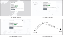
Fig.1
Three IGS points and GNSS network"
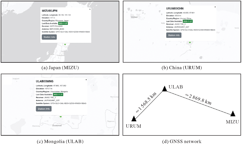
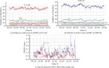
Fig.2
The charts of number of Multi-GNSS satellites"
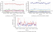
Fig.3
The charts of number of Multi-GNSS satellites"
Tab.2
Standard deviation, coordinates (ITRF 2014, Epoch 2021.1), distance values of the three IGS points by processing static GPS/GLONASS satellites (CSRS-PPP, Trimble RTX, AUSPOS Software)"
| Name | Latitude/(°) | Longitude/(°) | h/m | Std Lat /m | Std Lon /m | Std h/m | S (Distance)/km |
|---|---|---|---|---|---|---|---|
| CSRS-PPP (20.01.2021) | |||||||
| URUM | 43°48'2861958″N | 87°36'241980″E | 858860 | 0.003 | 0.002 | 0.010 | SULAB-URUM=1568.534452 SULAB-MIZU=2869.811953 |
| ULAB | 47°51'5424005″N | 107°03'839352″E | 1575557 | 0.003 | 0.002 | 0.010 | |
| MIZU | 39°8'0654730″N | 141°07'5833043″E | 117094 | 0.002 | 0.002 | 0.008 | |
| Trimble (20.01.2021) | |||||||
| URUM | 43°48'2861960″N | 87°36'2,41912″E | 858867 | 0.004 | 0.009 | 0.011 | SULAB-URUM=1568.534466 SULAB-MIZU=2869.811954 |
| ULAB | 47°51'5424002″N | 107°03'839348″E | 1575567 | 0.003 | 0.005 | 0.008 | |
| MIZU | 39°8'0654732″N | 141°07'5833040″E | 117091 | 0.004 | 0.008 | 0.010 | |
| AUSPOS (20.01.2021) | |||||||
| URUM | 43°48'2861956″N | 87°36'241978″E | 858868 | 0.005 | 0.004 | 0.009 | SULAB-URUM=1568.534449 SULAB-MIZU=2869.811952 |
| ULAB | 47°51'5423996″N | 107°03'839328″E | 1575568 | 0.005 | 0.004 | 0.012 | |
| MIZU | 39°8'0654740″N | 141°07'5832997″E | 117108 | 0.006 | 0.004 | 0.011 | |
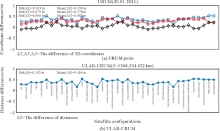
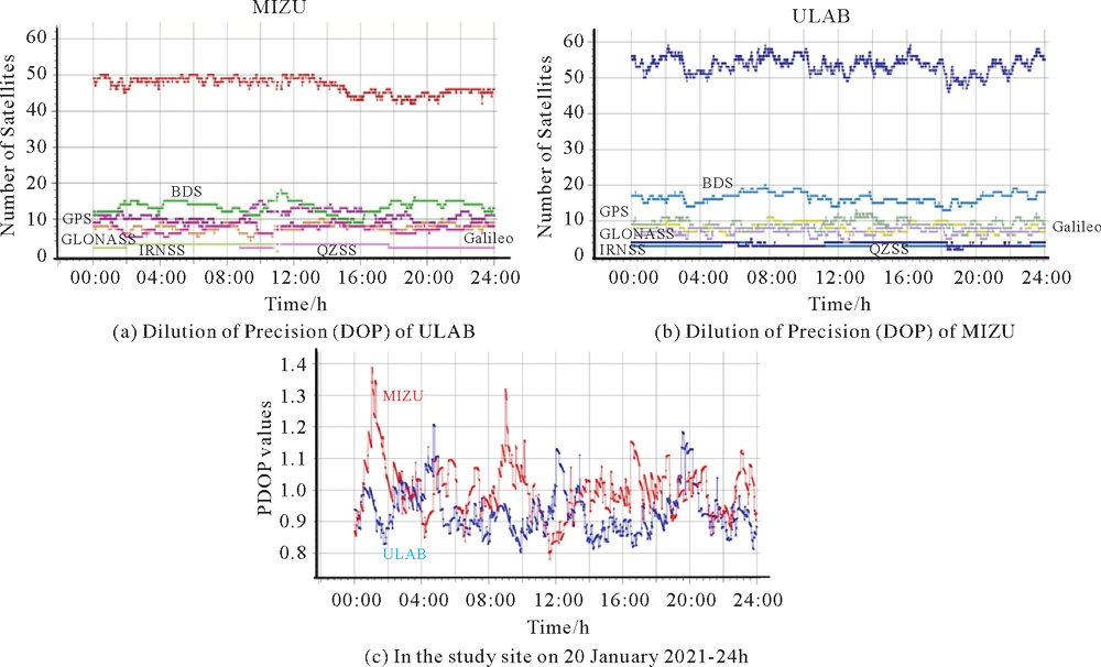
Fig.4
The Cartesian coordinate (WGS 84 system) differences and distance discrepancies of baseline between Topcon Magnet Tools Software results and CSRS-PPP results in the study site (20.01.2021)"

Fig.5
The Cartesian coordinate (WGS 84 system) differences and distance discrepancies of baseline between Topcon Magnet Tools Software results and CSRS-PPP results in the study site (20.01.2021)"
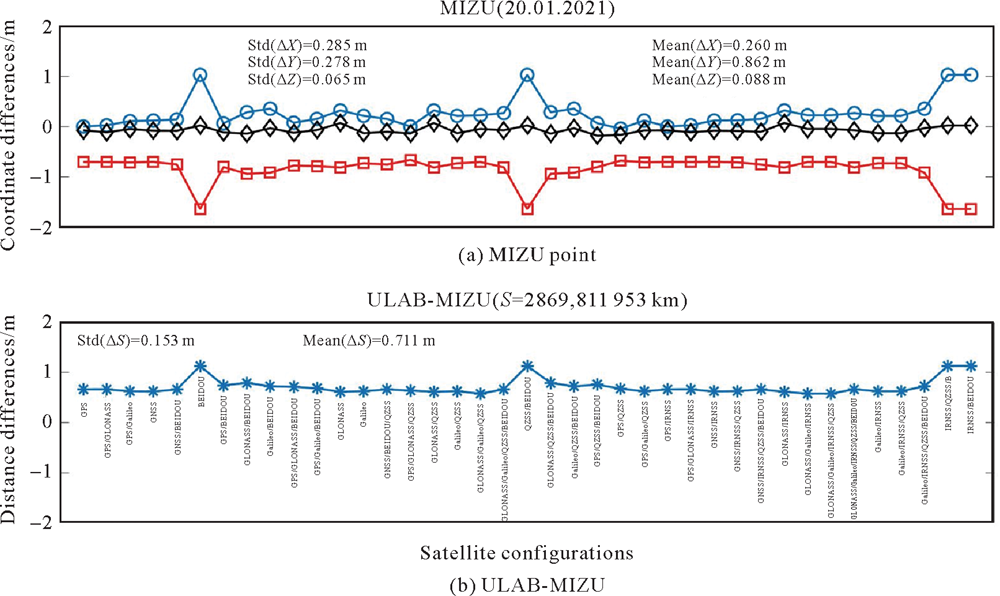
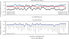
Fig.6
The Cartesian coordinate (WGS 84 system) differences and distance discrepancies of baseline between Topcon Magnet Tools Software results and CSRS-PPP results in the study site (20.02.2021)"
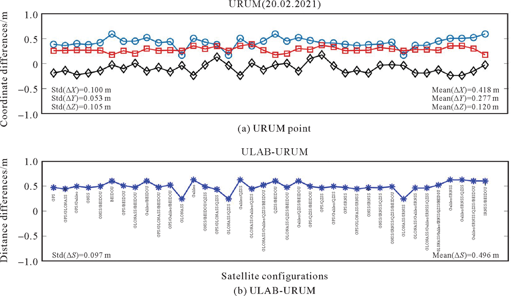
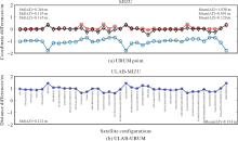
Fig.7
The Cartesian coordinate (WGS 84 system) differences and distance discrepancies of baseline between Topcon Magnet Tools Software results and CSRS-PPP results in the study site"
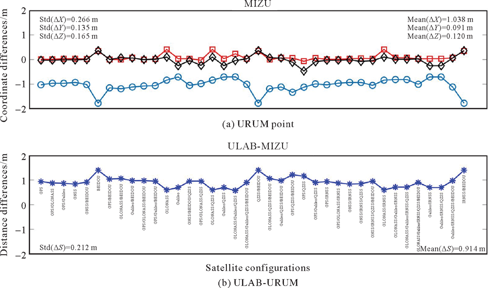

Fig.8
The Cartesian coordinate (WGS 84 system) differences and distance discrepancies of baseline between Topcon Magnet Tools Software results and CSRS-PPP results in the study site (21.03.2021)"
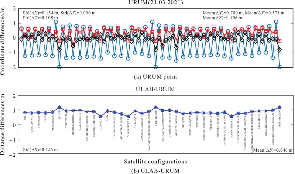
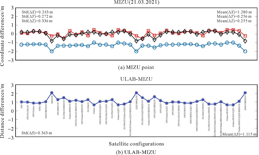
Fig.9
The Cartesian coordinate (WGS 84 system) differences and distance discrepancies of baseline between Topcon Magnet Tools Software results and CSRS-PPP results in the study site (21.03.2021)"
Tab.3
GPS relative positioning orders of accuracy[16-17]"
| Order | Allowable error ratio | Parts Per Million (PPM) |
|---|---|---|
| AA | 1∶100000000 | 0.01 |
| A | 1∶0000000 | 0.1 |
| B | 1∶1000000 | 1.0 |
| C-1 | 1∶100000 | 10 |
| C-2-Ⅰ | 1∶50000 | 20 |
| C-2-Ⅱ | 1∶20000 | 50 |
| C-3 | 1∶10000 | 100 |
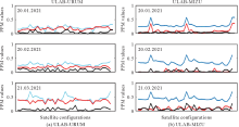
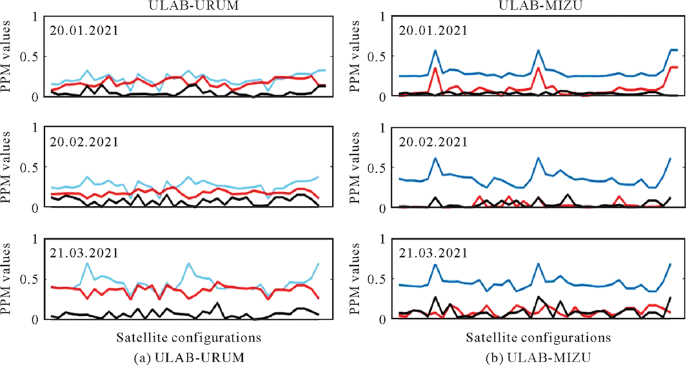
Fig.10
The values of parts per million (ppm) for two baselines on three days"
| [1] |
MONTENBRUCK O, STEIGENBERGER P, HAUSCHILD A. Multi-GNSS signal-in-space range error assessment-methodology and results[J]. Advances in Space Research, 2018, 61(12): 3020-3038.
doi: 10.1016/j.asr.2018.03.041 |
| [2] |
MONTENBRUCK O, STEIGENBERGER P, PRANGE L, et al. The Multi-GNSS Experiment (MGEX) of the International GNSS Service (IGS)—achievements, prospects and challenges[J]. Advances in Space Research, 2017, 59(7): 1671-1697.
doi: 10.1016/j.asr.2017.01.011 |
| [3] |
XIA Fengyu, YE Shirong, XIA Pengfei, et al. Assessing the latest performance of Galileo-only PPP and the contribution of Galileo to Multi-GNSS PPP[J]. Advances in Space Research, 2019, 63(9): 2784-2795.
doi: 10.1016/j.asr.2018.06.008 |
| [4] | ERKOÇ M H, DOĞAN U. Datum definition for geodetic vertical velocity field derived from GNSS observations: a case study in western and southern Turkey[J]. Bulletin of Geophysics and Oceanography, 2023, 64(2): 135-148. |
| [5] | CAI Changsheng, GAO Yang. Precise point positioning using combined GPS and GLONASS observations[J]. Journal of Global Positioning Systems, 2007, 6(1): 13-22. DOI: 10.5081/JGPS.6.1.13. |
| [6] | LI X, ZHANG X, GUO F. Study on precise point positioning based on combined GPS and GLONASS[C]//Proceedings of the 22nd International Technical Meeting of the Satellite Division of the Institute of Navigation. Savannah, GA: Savannah International Convention Center, 2009: 2449-2459. |
| [7] | TOLMAN B W, KERKHOFF A, RAINWATER D, et al. Absolute precise kinematic positioning with GPS and GLONASS[C]//Proceedings of the 23rd International Technical Meeting of the Satellite Division of The Institute of Navigation. Portland, OR: Oregon Convention Center, 2010: 2565-2576. |
| [8] | HE Haibo, LI Jinlong, YANG Yuanxi, et al. Performance assessment of single- and dual-frequency Beidou/GPS single-epoch kinematic positioning[J]. GPS Solutions, 2014, 18(3): 393-403, DOI: 10.1007/s10291-013-0339-3. |
| [9] | TEGEDOR J, ØVSTEDAL O, VIGEN E. Precise orbit determination and point positioning using GPS, GLONASS, Galileo and Beidou[J]. Journal of Geodetic Science, 2014, 4(1): 65-73. DOI: 10.2478/JOGS-2014-0008. |
| [10] | SANTERRE R, PAN Lin, CAI Changsheng, et al. Single point positioning using GPS, GLONASS and Beidou satellites[J]. Positioning, 2014, 5(4): 107-114. DOI: 10.4236/POS.2014.54013. |
| [11] | CAI Changsheng, PAN Lin, GAO Yang. A precise weighting approach with application to combined L1/B1 GPS/BEIDOU positioning[J]. The Journal of Navigation, 2014, 67(5): 911-925. DOI: 10.1017/S0373463314000320. |
| [12] |
LI Xingxing, ZHANG Xiaohong, REN Xiaodong, et al. Precise positioning with current multi-constellation Global Navigation Satellite Systems: GPS, GLONASS, Galileo and Beidou[J]. Scientific Reports, 2015, 5: 8328. DOI: 10.1038/SREP08328.
pmid: 25659949 |
| [13] | WANG Xiaolei, HE Xiufeng, ZHANG Qin, et al. Angle dependence analysis method to determine SNR arc applied to GNSS-MR sea level retrieval[J]. Journal of Geodesy and Geoinformation Science, 2021, 4(2): 14-26. doi: 10.11947/j.JGGS.2021.0202. |
| [14] | JIANG Weiping, ZHAO Qile, LI Min, et al. The progress of IGS analysis center at Wuhan University[J]. Journal of Geodesy and Geoinformation Science, 2023, 6(3): 46-57. DOI: 10.11947/j.JGGS.2023.0305. |
| [15] | ASWAL D K, YADAV S, TAKATSUJI T, et al. Handbook of metrology and applications[M]. Singapore: Springer, 2023: 512. |
| [16] | GHILANI C D, WOLF P R. Elementary surveying: an introduction to geomatics[M]. 13th ed. Upper Saddle River, NJ: Prentice Hall, 2012. |
| [17] |
CHOY S, HARIMA K, LI Yong, et al. GPS Precise point positioning with the japanese quasi-zenith satellite system LEX augmentation corrections[J]. The Journal of Navigation, 2015, 68(4): 769-783.
doi: 10.1017/S0373463314000915 |
| [18] | DESAI M V, JAGIWALA D, SHAH S N. Impact of dilution of precision for position computation in Indian regional navigation satellite system[C]//Proceedings of 2016 International Conference on Advances in Computing, Communications and Informatics. Jaipur: IEEE, 2016: 980-986. |
| [19] | IS-QZSS. Qusai-zenith satellite system navigation service (ver. 1.6), Japan Aerospace Exploration Agency[EB/OL]. [2014-06-04]. http://http://qz-vision.jaxa.jp/USE/is-qzss/DOCS/IS-QZSS_16_E.pdf. |
| [20] | Topcon magnet toolsmanuel[EB/OL]. [2015-09-02]. http://www.protsurv.com.na › uploads›2018/11(Magnet Tools Help(protsurv.com.na)). |
| [1] | Xudong ZHANG, Wenjun CHEN, Xiaodong ZHANG, Yajun ZHENG, Bin ZHANG, Shaoming WANG, Jiandong YUAN, Guozhen SUN. The Deformation Analysis of the 3D Alignment Control Network Based on the Multiple Congruence Models [J]. Journal of Geodesy and Geoinformation Science, 2023, 6(2): 21-31. |
| [2] | Xueliang LU, Jianrong WANG, Xiuce YANG, Yuan LYU, Yan HU, Bincai CAO, Junming ZHOU. On-orbit Geometric Calibration and Preliminary Accuracy Evaluation of GF-14 Satellite [J]. Journal of Geodesy and Geoinformation Science, 2023, 6(2): 62-70. |
| [3] | Kun QIN,Hui LIN,Yang YUE,Feng ZHANG,Jianya GONG. Spatial Humanities and Geo-computation for Social Sciences:Advances and Applications [J]. Journal of Geodesy and Geoinformation Science, 2022, 5(2): 1-6. |
| [4] | Zhuo LIU,Hui LIN,Qinghua HE,Yuling WANG. Temporal-spatial Distribution of Various Types of Crime in the Special Wards of Tokyo [J]. Journal of Geodesy and Geoinformation Science, 2022, 5(2): 19-28. |
| [5] | Lai CHEN,Chaogui KANG,Chao YANG. Understanding Citizens’emotion States under the Urban Livability Environment through Social Media Data: a Case Study of Wuhan [J]. Journal of Geodesy and Geoinformation Science, 2022, 5(2): 49-59. |
| [6] | An HUAI,Xueying ZHANG,Weicheng AI,Tianyang CAO. Spatial-temporal Analysis of Emotions in Society in News [J]. Journal of Geodesy and Geoinformation Science, 2022, 5(2): 98-110. |
| [7] | Jiaqi YAO,Guoyuan LI,Jiyi CHEN,Genghua HUANG,Xiongdan YANG,Shuaitai ZHANG. Cloud Detection and Centroid Extraction of Laser Footprint Image of GF-7 Satellite Laser Altimetry [J]. Journal of Geodesy and Geoinformation Science, 2021, 4(3): 1-12. |
| [8] | Junfeng XIE,Ren LIU,Yongkang MEI,Wei LIU,Jianping PAN. Preliminary Pointing Bias Calibration of ZY3-03 Laser Altimeter [J]. Journal of Geodesy and Geoinformation Science, 2021, 4(3): 91-100. |
| [9] | Yueqian SHEN,Jinguo WANG,Jinhu WANG,Wei DUAN,Vagner G. FERREIRA. Methodology for Extraction of Tunnel Cross-Sections Using Dense Point Cloud Data [J]. Journal of Geodesy and Geoinformation Science, 2021, 4(2): 56-71. |
| [10] | Jian MA, Ziqing WEI, Hongfei REN. The Spectral Analysis and Application of Low-degree Modified Spheroidal Hotine Kernel [J]. Journal of Geodesy and Geoinformation Science, 2020, 3(3): 104-114. |
| [11] | Guoyuan LI,Fanghong YE,Xinming TANG,Dongping XIE,Jiapeng HUANG,Genhua HUANG. Influence of Range Gate Width on Detection Probability and Ranging Accuracy of Single Photon Laser Altimetry Satellite [J]. Journal of Geodesy and Geoinformation Science, 2020, 3(2): 36-44. |
| [12] | Yangjun GAO,Zhiwei LV,Pengjin ZHOU,Zhengyang JIA,Lundong ZHANG,Dianwei CONG. Adaptive Robust Filtering Algorithm for BDS Medium and Long Baseline Three Carrier Ambiguity Resolution [J]. Journal of Geodesy and Geoinformation Science, 2020, 3(2): 53-61. |
| [13] | Motao HUANG,Kailiang DENG,Taiqi WU,Xiuping LU,Guojun ZHAI,Yongzhong OUYANG,Xin CHEN,Min LIU. Research and Evaluation on Key Technological Indicators for Airborne and Shipborne Gravimetry [J]. Journal of Geodesy and Geoinformation Science, 2019, 2(3): 44-54. |
| [14] | Tian ZENG,Lifen SUI,Xiaolin JIA,Guofeng JI,Qinghua ZHANG. Results and Analyses of BDS Precise Orbit Determination with the Enhancement of Fengyun-3C [J]. Journal of Geodesy and Geoinformation Science, 2019, 2(3): 68-78. |
| [15] | Lei YAN,Zhengkang ZUO,Yingcheng LI,Xiuxiao YUAN,Yan SONG,Qingsheng XUE,Shihu ZHAO. General Structure Physics of an Aerial Remote Sensing Platform and Its Systemic Accuracy Criterion [J]. Journal of Geodesy and Geoinformation Science, 2019, 2(2): 2-16. |
| Viewed | ||||||
|
Full text |
|
|||||
|
Abstract |
|
|||||