
Journal of Geodesy and Geoinformation Science ›› 2021, Vol. 4 ›› Issue (2): 56-71.doi: 10.11947/j.JGGS.2021.0206
• Special Issue • Previous Articles Next Articles
Yueqian SHEN1( ),Jinguo WANG1(),Jinhu WANG2,Wei DUAN3,Vagner G. FERREIRA1
Received:2020-09-27
Accepted:2020-12-03
Online:2021-06-20
Published:2021-07-02
Contact:
Jinguo WANG
E-mail:y.shen_lidar@hhu.edu.cn;wang_jinguo@hhu.edu.cn
About author:Yueqian SHEN (1988—), male, PhD, associate professor, majors in Geodesy and Surveying Engineering. E-mail: Supported by:Yueqian SHEN,Jinguo WANG,Jinhu WANG,Wei DUAN,Vagner G. FERREIRA. Methodology for Extraction of Tunnel Cross-Sections Using Dense Point Cloud Data[J]. Journal of Geodesy and Geoinformation Science, 2021, 4(2): 56-71.
Add to citation manager EndNote|Reference Manager|ProCite|BibTeX|RefWorks
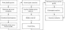
Fig.1
The workflow of the proposed methodology"
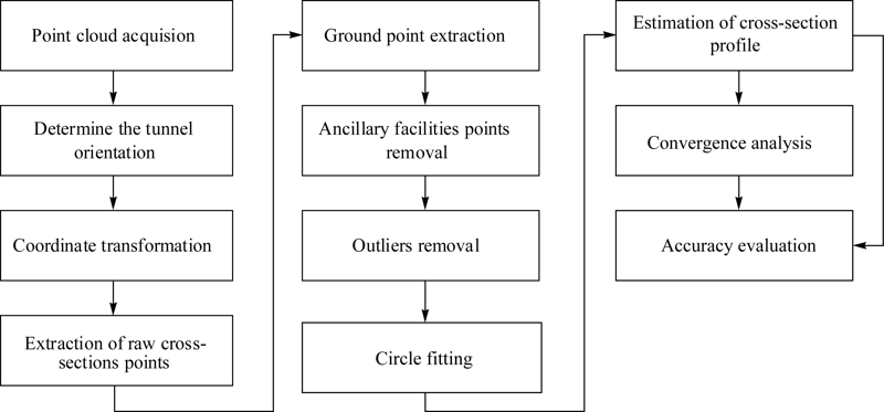
Fig.2
Graphical illustration of the TLS and tunnel coordinate systems"
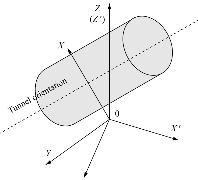
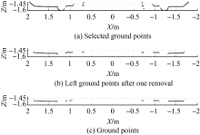
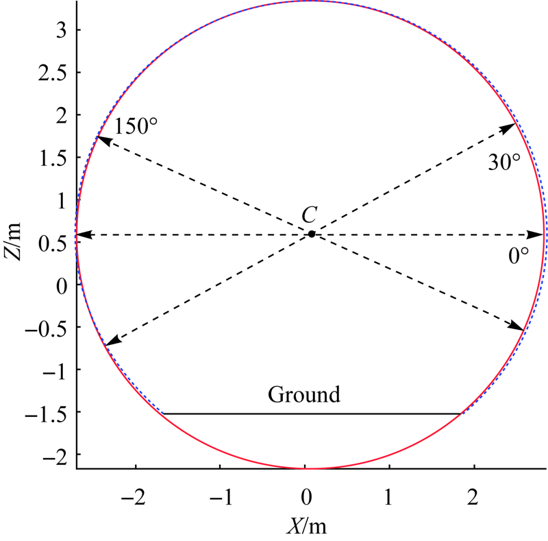
Fig.3
An example of the ground point extraction"
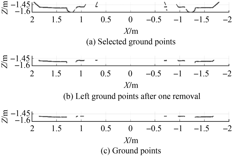
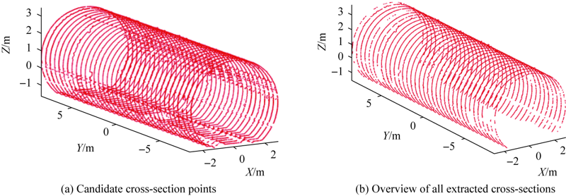
Fig.4
The standard deviations of the distances (ρ) for raw tunnel cross-section"
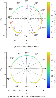
Fig.5
Cross-section points colored by the distance to the control point"


Fig.6
Cross-section points colored by distance to the second control point"
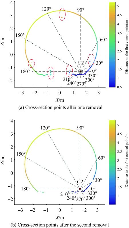

Fig.7
The standard deviation of distances ρ after two-steps point removal"
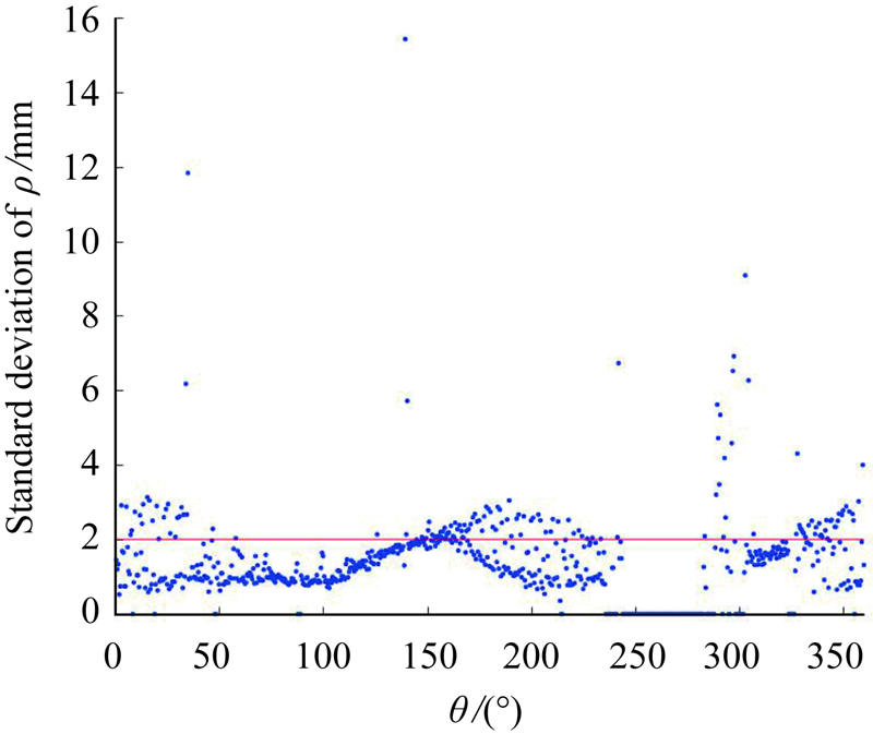
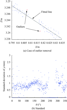
Fig.8
Graphical illustration of the outlier removal"


Fig.9
An example of circle fitting (The red line is the fitted circle and the blue dots are the cross-section points extracted)"
Tab.1
Specification of FARO Focus3D X330"
| Range | 0.6m to 330m | Weight | 5.2kg |
|---|---|---|---|
| Measurement | Up to 976000 points/s | Size | 240×200× 100mm |
| Accuracy | ± 2mm | Acquired data | XYZ+Intensity+ RGB |
| Step size | 0.009°(Vertical) 0.009°(Horizontal) | Field of view | 360°(Vertical) 360°(Horizontal) |

Fig.10
Cross-section extraction"
Tab.2
Standard deviations of the distancesmm"
| ID | The standard deviation of distances | ID | The standard deviation of distances | ID | The standard deviation of distances | ID | The standard deviation of distances |
|---|---|---|---|---|---|---|---|
| 1 | 13.22 | 10 | 14.11 | 19 | 13.14 | 28 | 24.27 |
| 2 | 19.07 | 11 | 22.15 | 20 | 13.16 | 29 | 14.54 |
| 3 | 13.61 | 12 | 14.67 | 21 | 12.41 | 30 | 13.45 |
| 4 | 18.03 | 13 | 13.45 | 22 | 16.50 | 31 | 11.61 |
| 5 | 19.77 | 14 | 14.21 | 23 | 13.65 | 32 | 12.88 |
| 6 | 12.65 | 15 | 13.10 | 24 | 13.97 | 33 | 12.18 |
| 7 | 14.29 | 16 | 23.19 | 25 | 11.82 | 34 | 20.16 |
| 8 | 13.89 | 17 | 25.08 | 26 | 10.87 | 35 | 13.89 |
| 9 | 12.83 | 18 | 11.71 | 27 | 12.36 | — | — |

Fig.11
An example of cross-sections with large standard deviation of distances"
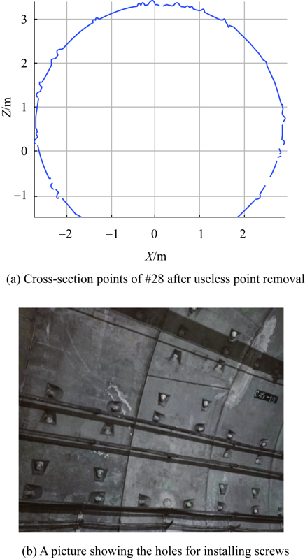
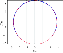
Fig.12
Secondary fitting results (The red line is the secondary fitted circle and the blue dots are the cross-section point extracted)"

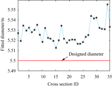
Fig.13
Comparison of the fitted diameters and the designed diameter"
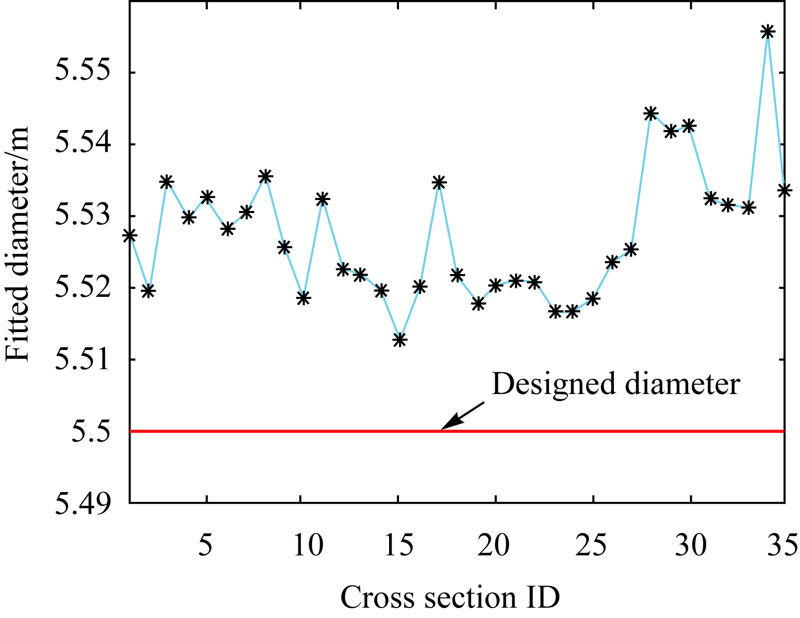
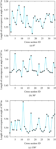
Fig.14
Extracted length of convergence at different angles"
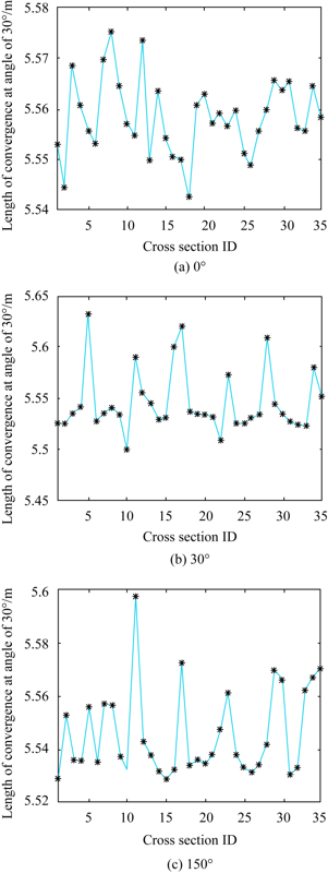

Fig.15
Fitted radius comparison (The symbol “*” denotes the fitted radius using TLS method while the symbol “^” is the fitted radius using total station method)"
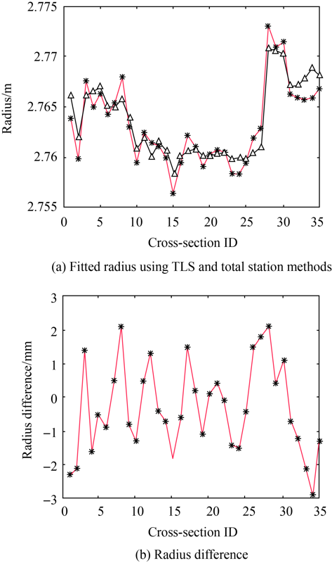
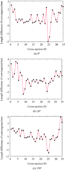
Fig.16
Length difference of convergence at different angles"

| [1] |
WANG T T, JAW J J, CHANG Y H, et al. Application and validation of profile-image method for measuring deformation of tunnel wall[J]. Tunnelling and Underground Space Technology, 2009,24(2):136-147.
doi: 10.1016/j.tust.2008.05.008 |
| [2] |
SCAIONI M, BARAZZETTI L, GIUSSANI A, et al. Photogrammetric techniques for monitoring tunnel deformation[J]. Earth Science Informatics, 2014,7(2):83-95.
doi: 10.1007/s12145-014-0152-8 |
| [3] | ALBA M, BARAZZETTI L, GIUSSANI A, et al. Development and testing of a method for tunnel monitoring via vision metrology[C]// International Archives of Photogrammetry, Remote Sensing and Spatial Information Sciences. Newcastle upon Tyne, UK: [s.n], 2010,2(3):143-145. |
| [4] |
ARGÜELLES-FRAGA R, ORDÓÑEZ C, GARCÍA-CORTÉS S, et al. Measurement planning for circular cross-section tunnels using terrestrial laser scanning[J]. Automation in Construction, 2013,31:1-9.
doi: 10.1016/j.autcon.2012.11.023 |
| [5] |
AYGÜN B, GUNGOR V C. Wireless sensor networks for structure health monitoring: recent advances and future research directions[J]. Sensor Review, 2011,31(3):261-276.
doi: 10.1108/02602281111140038 |
| [6] | VOSSELMAN G, MAAS H G. Airborne and terrestrial laser scanning[M]. Dunbeath, United Kingdom: Whittles Publishing, 2010. |
| [7] | LI Bin, ZHAO Xiaofa, CHEN Yong, et al. Three dimensional laser point cloud slicing method for calculating irregular volume[J]. Journal of Geodesy and Geoinformation Science, 2019,2(4):31-43. DOI: 10.11947/j.JGGS.2019.0404. |
| [8] | ZHANG Yongjun, XIONG Xiaodong, WANG Mengqiu, et al. A fast aerial image matching method using airborne LiDAR point cloud and POS data[J]. Journal of Geodesy and Geoinformation Science, 2019,2(1):26-36. DOI: 10.11947/j.JGGS.2019.0104. |
| [9] | ZHU Zan, GAN Shu, WANG Jianqi, et al. A novel airborne 3D laser point cloud hole repair algorithm considering topographic features[J]. Journal of Geodesy and Geoinformation Science, 2020,3(3):29-38. DOI: 10.11947/j.JGGS.2020.0303. |
| [10] |
BARNHART T B, CROSBY B T. Comparing two methods of surface change detection on an evolving thermokarst using high-temporal-frequency terrestrial laser scanning, Selawik River, Alaska[J]. Remote Sensing, 2013,5(6):2813-2837.
doi: 10.3390/rs5062813 |
| [11] | SCHUEREMANS L, VANGENECHTEN B. The use of 3D-laser scanning in assessing the safety of masonry vaults—A case study on the church of Saint-Jacobs[J]. Opticsand Lasers in Engineering, 2009,47(3-4):329-335. |
| [12] | SAHIN C, ALKIS A, ERGUN B, et al. Producing 3D city model with the combined photogrammetric and laser scanner data in the example of Taksim Cumhuriyet square[J]. Opticsand Lasers in Engineering, 2012,50(12):1844-1853. |
| [13] |
GHUFFAR S, SZÉKELY B, RONCAT A, et al. Landslide displacement monitoring using 3D range flow on airborne and terrestrial LiDAR data[J]. Remote Sensing, 2013,5(6):2720-2745.
doi: 10.3390/rs5062720 |
| [14] |
DE JONG R, VERBESSELT J, ZEILEIS A, et al. Shifts in global vegetation activity trends[J]. Remote Sensing, 2013,5(3):1117-1133.
doi: 10.3390/rs5031117 |
| [15] |
XU Teng, XU Lijun, LI Xiaolu, et al. Detection of water leakage in underground tunnels using corrected intensity data and 3D point cloud of terrestrial laser scanning[J]. IEEE Access, 2018,6:32471-32480.
doi: 10.1109/ACCESS.2018.2842797 |
| [16] |
ZHOU Yuhui, WANG Shaohua, MEI Xi, et al. Railway tunnel clearance inspection method based on 3D point cloud from mobile laser scanning[J]. Sensors, 2017,17(9):2055.
doi: 10.3390/s17092055 |
| [17] |
XIE Xiongyao, LU Xiaozhi. Development of a 3D modeling algorithm for tunnel deformation monitoring based on terrestrial laser scanning[J]. Underground Space, 2017,2(1):16-29.
doi: 10.1016/j.undsp.2017.02.001 |
| [18] | LINDENBERGH R, PFEIFER N, RABBANI T. Accuracy analysis of the Leica HDS3000 and feasibility of tunnel deformation monitoring[C]// Proceedings of the ISPRS W III/3, III/4, V/3 Workshop "Laser Scanning 2005". Enschede, The Netherlands: ISPRS Working Groups, 2005,36:24-29. |
| [19] | LEMY F, YONG S, SCHULZ T. A case study of monitoring tunnel wall displacement using laser scanning technology[C]// Proceedings of the 10th IAEG Congress “Engineering Geology for Tomorrow’s Cities”. Nottingham: The Geological Society of London, 2006. |
| [20] | VAN GOSLIGA R, LINDENBERGH R, PFEIFER N. Deformation analysis of a bored tunnel by means of terrestrial laser scanning[C]// Proceedings of the ISPRS Commission V Symposium Image Engineering and Vision Metrology. Dresden, Germany: ISPRS Commission, 2006: 167-172. |
| [21] | LI J, WAN Y, GAO X. A new approach for subway tunnel deformation monitoring: high-resolution terrestrial laser scanning[C]// Proceedings of the International Archives of the Photogrammetry, Remote Sensing and Spatial Information Sciences. Melbourne, Australia: [s.n.], 2012, XXXIX-B5:223-228. |
| [22] |
FEKETE S, DIEDERICHS M, LATO M. Geotechnical and operational applications for 3-dimensional laser scanning in drill and blast tunnels[J]. Tunnelling and Underground Space Technology, 2010,25(5):614-628.
doi: 10.1016/j.tust.2010.04.008 |
| [23] |
GIKAS V. Three-dimensional laser scanning for geometry documentation and construction management of highway tunnels during excavation[J]. Sensors, 2012,12(8):11249-11270.
doi: 10.3390/s120811249 |
| [24] | PEJIĆ M. Design and optimisation of laser scanning for tunnels geometry inspection[J]. Tunnellingand Underground Space Technology, 2013,37:199-206. |
| [25] | DELALOYE D, HUTCHINSON J, DIEDERICHS M. Using terrestrial LiDAR for tunnel deformation monitoring in circular tunnels and shafts[C]// Proceedings of ISRM International Symposium-EUROCK 2012. Stockholm, Sweden: ISRMEUROCK, 2012: 1-13. |
| [26] |
HAN J Y, GUO J, JIANG Y S. Monitoring tunnel profile by means of multi-epoch dispersed 3-D LiDAR point clouds[J]. Tunnelling and Underground Space Technology, 2013,33:186-192.
doi: 10.1016/j.tust.2012.08.008 |
| [27] |
KANG Zhizhong, ZHANG Liqiang, TUO Lei, et al. Continuous extraction of subway tunnel cross sections based on terrestrial point clouds[J]. Remote Sensing, 2014,6(1):857-879.
doi: 10.3390/rs6010857 |
| [28] |
NUTTENS T, STAL C, DE BACKER H, et al. Methodology for the ovalization monitoring of newly built circular train tunnels based on laser scanning: Liefkenshoek Rail Link (Belgium)[J]. Automation in Construction, 2014,43:1-9.
doi: 10.1016/j.autcon.2014.02.017 |
| [29] | DELALOYE D, DIEDERICHS M S, WALTON G, et al. Sensitivity testing of the newly developed elliptical fitting method for the measurement of convergence in tunnels and shafts[J]. Rock Mechanicsand Rock Engineering, 2015,48(2):651-667. |
| [30] |
CABO C, ORDÓÑEZ C, ARGÜELLES-FRAGA R. An algorithm for optimizing terrestrial laser scanning in tunnels[J]. Automation in Construction, 2017,83:163-168.
doi: 10.1016/j.autcon.2017.08.028 |
| [31] | SEO D J, LEE J C, LEE Y D. Development of cross section management system in tunnel using terrestrial laser scanning technique[C]// Proceedings of the International Archives of the Photogrammetry, Remote Sensing and Spatial Information Sciences.Beijing: [s.n.], 2008,XXXVII:573-581. |
| [32] | JOLLIFFE I T. Principal component analysis[J]. Journal of Marketing Research, 2002,87(100):513. |
| [33] | SAHIN C. Planar segmentation of indoor terrestrial laser scanning point clouds via distance function from a point to a plane[J]. Opticsand Lasers in Engineering, 2015,64:23-31. |
| [34] | NURUNNABI A, WEST G, BELTON D. Robust outlier detection and saliency features estimation in point cloud data[C]// Proceedings of 2013 International Conference on Computer and Robot Vision. Regina, SK, Canada:IEEE, 2013: 98-105. |
| [35] | ROUSSEEUW P J, HUBERT M. Robust statistics for outlier detection[J]. WIREsData Mining and Knowledge Discovery, 2011,1(1):73-79. |
| [36] |
SOUDARISSANANE S, LINDENBERGH R, MENENTI M, et al. Scanning geometry: Influencing factor on the quality of terrestrial laser scanning points[J]. ISPRS Journal of Photogrammetry and Remote Sensing, 2011,66(4):389-399.
doi: 10.1016/j.isprsjprs.2011.01.005 |
| [37] |
DU Zhengchun, WU Zhaoyong, YANG Jianguo. Point cloud uncertainty analysis for laser radar measurement system based on error ellipsoid model[J]. Optics and Lasers in Engineering, 2016,79:78-84.
doi: 10.1016/j.optlaseng.2015.11.010 |
| [38] |
RAK M B, WOZNIAK A, MAYER J R R. The use of low density high accuracy (LDHA) data for correction of high density low accuracy (HDLA) point cloud[J]. Optics and Lasers in Engineering, 2016,81:140-150.
doi: 10.1016/j.optlaseng.2016.01.005 |
| [1] | Wenzhou SUN,Xiaodong YIN,Jingyang BAO,Anmin ZENG. Semi-parametric Adjustment Model Methods for Positioning of Seafloor Control Point [J]. Journal of Geodesy and Geoinformation Science, 2020, 3(1): 85-92. |
| Viewed | ||||||
|
Full text |
|
|||||
|
Abstract |
|
|||||