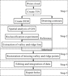
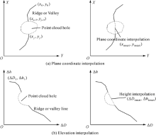
| [1] |
GUISADO-PINTADO E, JACKSON D W T, ROGERS D. 3D mapping efficacy of a drone and terrestrial laser scanner over a temperate beach-dune zone[J]. Geomorphology, 2019,328:157-172.
|
| [2] |
QIU Junlin, XIA Qinglin, YAO Lingqing , et al. Mine geological modeling and application based on the three-dimensional laser scanner technology[J]. Earth Science-Journal of China University of Geosciences, 2012,37(6):1209-1216.
|
| [3] |
KASZA D . Modelling of underground objects and geological-tectonic structures from a point cloud: application of the developed models in studies of geodynamic processes[J]. E3s Web of Conferences, 2018,55:00014.
|
| [4] |
SANCHEZ V, ZAKHOR A. Planar 3D modeling of building interiors from point cloud data [C]∥Proceedings of the 2012 19th IEEE International Conference on Image Processing. Orlando, FL: IEEE, 2012: 1777-1780.
|
| [5] |
MI Chao, SHEN Yang, MI Weijian , et al. Ship identification algorithm based on 3D point cloud for automated ship loaders[J]. Journal of Coastal Research, 2015,73(sp1):28-34.
|
| [6] |
GUO Jiateng, LIU Shanjun, ZHANG Peina , et al. Towards semi-automatic rock mass discontinuity orientation and set analysis from 3D point clouds[J]. Computers & Geosciences, 2017,103:164-172.
|
| [7] |
YANG Huijun, CHANG Jian, GENG Nan , et al. Texture organisation and mapping on Citrus sinensis point cloud[J]. Multimedia Tools and Applications, 2017,76:14711-14732.
|
| [8] |
ZHANG Chengyi, ARDITI D . Automated progress control using laser scanning technology[J]. Automation in Construction, 2013,36:108-116.
|
| [9] |
WITT III E C . Evaluation of the U.S. Geological Survey standard elevation products in a two-dimensional hydraulic modeling application for a low relief coastal floodplain[J]. Journal of Hydrology, 2015,531:759-767.
|
| [10] |
LI Bin, ZHAO Xiaofa, CHEN Yong , et al. Three dimensional laser point cloud slicing method for calculating irregular volume[J]. Journal of Geodesy and Geoinformation Science, 2019,2(4):31-43.
|
| [11] |
DENG Fei, ZHANG Zuxun, ZHANG Jianqing . 3D reconstruction of old architecture by laser scanner and digital camera[J]. Science of Surveying and Mapping, 2007,32(2):29-30.
|
| [12] |
YANG Bisheng, LIANG Fuxun, HUANG Ronggang . Progress, challenges and perspectives of 3D LIDAR point cloud processing[J]. Acta Geodaetica et Cartographica Sinica, 2017,46(10):1509-1516. DOI: 10.11947/j.AGCS.2017.20170351.
|
| [13] |
WANG Jianning, OLIVEIRA M M . Filling holes on locally smooth surfaces reconstructed from point clouds[J]. Image and Vision Computing, 2007,25(1):103-113.
|
| [14] |
LIANG P, ZHOU G Q, LU Y L, et al. Hole-filling algorithm for airborne LiDAR point cloud data[C]∥Proceedings of the International Conference on Geomatics in the Big Data Era. Guilin, China: International Society of Photogrammetry and Remote Sensing(ISPRS). 2020, XLII-3/W10:739-745.
|
| [15] |
LI Hailiang, DENG Fei, LI Gang . Repairing holes of laser scanning point cloud based on photogrammetry[J]. Science of Surveying and Mapping, 2010,35(5):101-102.
|
| [16] |
BAREQUET G, SHARIR M . Filling gaps in the boundary of a polyhedron[J]. Computer Aided Geometric Design, 1995,12(2):207-229.
|
| [17] |
CAO Junjie, TAGLIASACCHI A, OLSON M, et al. Point cloud skeletons via laplacian based contraction [C]∥Proceedings of 2010 Shape Modeling International Conference. Aix-en-Provence, France: IEEE, 2010.
|
| [18] |
QUINSAT Y, LARTIGUE C . Filling holes in digitized point cloud using a morphing-based approach to preserve volume characteristics[J]. The International Journal of Advanced Manufacturing Technology, 2015,81(1-4):411-421.
|
| [19] |
LIU Bin, SHANGGUAN Ning, JIANG Kaiyong , et al. Triangular mesh model reconstruction from scan point clouds based on template[J]. Tsinghua Science & Technology, 2009,14(S1):56-61.
|
| [20] |
ZHANG Ruonan, WANG Renfang . Extraction of valley-ridge lines from point-sampled geometry with snake[J]. Journal of Graphics, 2015,36(5):662-670.
|
| [21] |
DANIELS II J, HA L K, OCHOTTA T, et al. Robust smooth feature extraction from point clouds [C]∥Proceedings of IEEE International Conference on Shape Modeling and Applications 2007. Lyon, France: IEEE, 2007: 123-136.
|
| [22] |
LI Min, YANG Xin, CHEN Panpan , et al. Method of automatic shoulder line extraction in the Loess Hilly Area based on point cloud data[J]. Journal of Geo-information Science, 2016,18(7):869-877.
|
| [23] |
PAULY M, KEISER R, GROSS M . Multi-scale feature extraction on point-sampled surfaces[J]. Computer Graphics Forum, 2003,22(3):281-289.
|
| [24] |
ZHANG Jixian, LIN Xiangguo, LIANG Xinlian . Advances and prospects of information extraction from point clouds[J]. Acta Geodaetica et Cartographica Sinica, 2017,46(10):1460-1469. DOI: 10.11947/j.AGCS.2017.20170345.
|
| [25] |
STRAYER D L, BEIGHLEY R E, THOMPSON L C , et al. Effects of land cover on stream ecosystems: roles of empirical models and scaling issues[J]. Ecosystems, 2003,6(5):407-423.
|
| [26] |
CHEN Xiang, TONG Xiaohua . Research on points cloud hole filling algorithm and accuracy in triangle mesh[J]. Bulletin of Surveying and Mapping, 2013(4):1-3.
|

 ), Jianqi WANG1(