
Journal of Geodesy and Geoinformation Science ›› 2022, Vol. 5 ›› Issue (1): 60-72.doi: 10.11947/j.JGGS.2022.0107
• Special Issue • Previous Articles Next Articles
Lyu ZHOU1( ),Yizhan ZHAO1(),Zilin ZHU2,Chao REN1,Fei YANG3,Ling HUANG1,Xin LI4
Received:2021-07-15
Accepted:2022-01-02
Online:2022-03-20
Published:2022-03-31
Contact:
Yizhan ZHAO
E-mail:zhoulv@glut.edu.cn;1722393110@qq.com
About author:Lyu ZHOU (1988—), male, PhD, associate professor, majors in InSAR data processing theory and algorithm, and geohazard monitoring. E-mail: Supported by:Lyu ZHOU,Yizhan ZHAO,Zilin ZHU,Chao REN,Fei YANG,Ling HUANG,Xin LI. Spatial and Temporal Evolution of Surface Subsidence in Tianjin from 2015 to 2020 Based on SBAS-InSAR Technology[J]. Journal of Geodesy and Geoinformation Science, 2022, 5(1): 60-72.
Add to citation manager EndNote|Reference Manager|ProCite|BibTeX|RefWorks

Fig.1
Study area in Tianjin, China (the range of the red box illustrated is the study area)"

Tab.1
SAR data parameters"
| Parameter | Value | Parameter | Value |
|---|---|---|---|
| Sensor | Sentinel-1A | Wavelength | 5.55cm |
| Band | C | Pass direction | Ascending |
| Incidence angle | 39.25 | Number of scenes | 44 |
| Polarization | VH | Time range | 2015-07-25— 2020-04-17 |
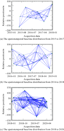
Fig.2
Relative spatial baseline connectivity map for each period (The green dot represents the SAR image, the line segment represents the interferogram, and the yellow dot represents the master image)"

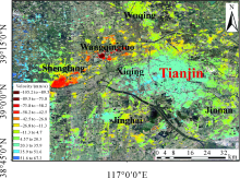
Fig.3
Surface vertical subsidence rate in Tianjin from 2015 to 2017"


Fig.4
Surface vertical subsidence rate in Tianjin from 2016 to 2018"


Fig.5
Surface vertical subsidence rate in Tianjin from 2018 to 2020"

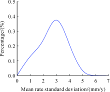
Fig.6
Probability density function of the standard deviation of the average velocity"

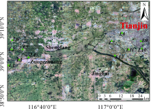
Fig.7
Distribution of benchmark (The green points are the benchmark)"

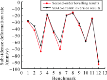
Fig.8
Comparison of second-order leveling and SBAS-InSAR results in 2015"


Fig.9
Regression analysis"
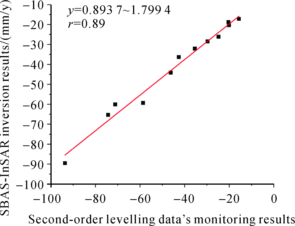
Fig.10
Time series of cumulative subsidence in Tianjin area from 2018 to 2020"


Fig.11
Distribution of feature points (The green triangles are the feature points)"
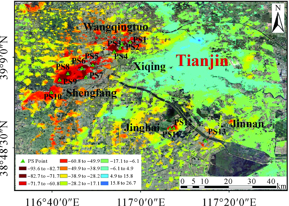

Fig.12
Feature points PS1, PS2, PS3, PS4 cumulative sedimentation"


Fig.13
Feature points PS5, PS6, PS7, PS8, PS9, PS10 cumulative sedimentation"
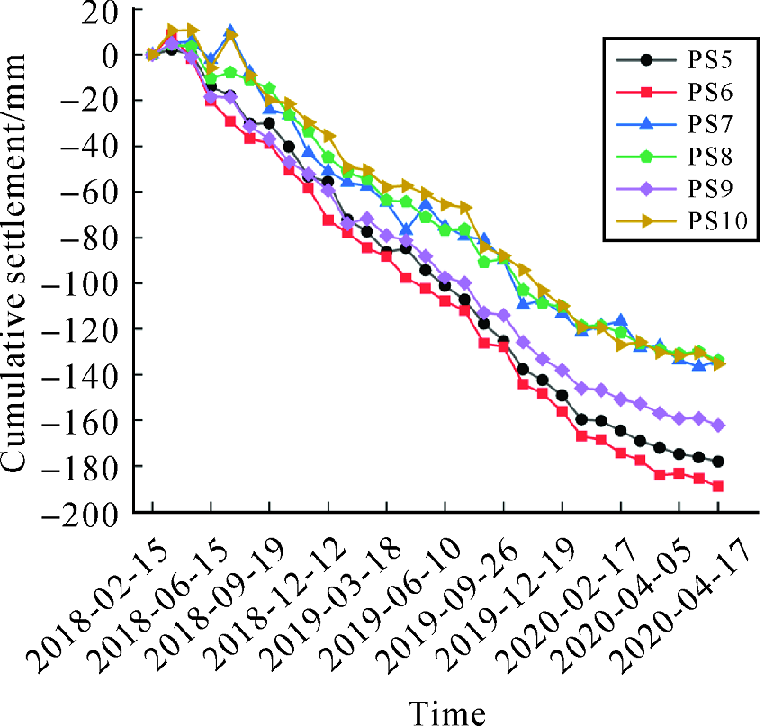

Fig.14
Feature points PS11, PS12, PS13 cumulative sedimentation"

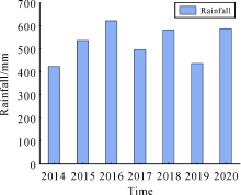
Fig.15
Changes in rainfall in Tianjin from 2014 to 2020"

Fig.16
Subsidence points location distribution"
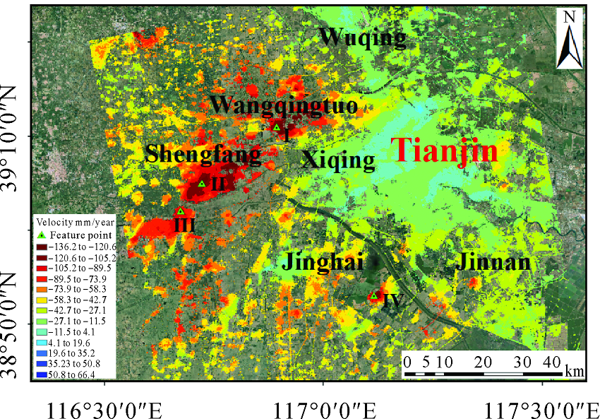

Fig.17
Relationship between time series of subsidence points and rainfall"
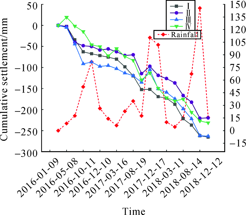
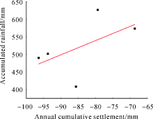
Fig.18
Regression analysis"

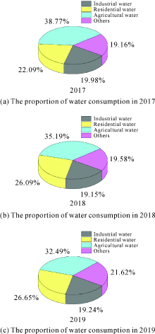
Fig.19
Proportion of water consumption in Tianjin from 2017 to 2019"

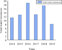
Fig.20
Total water resources in Tianjin from 2014 to 2019"

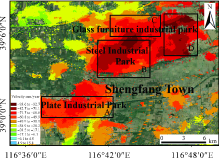
Fig.21
Surface vertical subsidence velocity of Sheng-fang Town from 2018 to 2020"
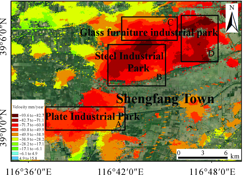
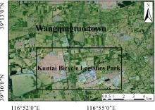
Fig.22
Surface space utilization in Wangqingtuo Town"

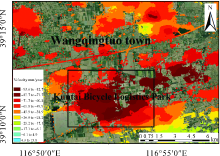
Fig.23
Surface vertical subsidence velocity of Wangqingtuo Town from 2018 to 2020"

| [1] |
QU Feifei, ZHANG Qin, LU Zhong, et al. Land subsidence and ground fissures in Xi’an, China 2005-2012 revealed by multi-band InSAR time-series analysis[J]. Remote Sensing of Environment, 2014, 155: 366-376.
doi: 10.1016/j.rse.2014.09.008 |
| [2] |
ANDREW SOWTERA, MOH. B C A, FRANCESCA CIGNAB, et al. Mexico City land subsidence in 2014-2015 with sentinel-1 IW TOPS: results using the Intermittent SBAS (ISBAS) technique[J]. International Journal of Applied Earth Observation and Geoinformation, 2016, 52: 230-242.
doi: 10.1016/j.jag.2016.06.015 |
| [3] | XIAO Ningning. Surface deformation evaluation in Chengdu using time-series InSAR technique[D]. Chengdu: University of Electronic Science and Technology of China, 2019. |
| [4] |
ZHOU Chaofan, GONG Huili, CHEN Beibei, et al. Land subsidence response to different land use types and water resource utilization in Beijing-Tianjin-Hebei, China[J]. Remote Sensing, 2020, 12(3): 457.
doi: 10.3390/rs12030457 |
| [5] |
MUHETAER N, YU Jie, WANG Yanbing, et al. Temporal and spatial evolution characteristics analysis of Beijing land subsidence based on InSAR[J]. IOP Conference Series: Earth and Environmental Science, 2021, 658: 012050.
doi: 10.1088/1755-1315/658/1/012050 |
| [6] | ZHOU Chaofan, GONG Huili, CHEN Beibei, et al. Study of temporal and spatial characteristics of land subsidence in Beijing[J]. Journal of Geo-Information Science, 2017, 19(2): 205-215. |
| [7] | DONG Kegang, WANG Wei, YU Qiang, et al. Ratio of soil loss to groundwater-exploitation in the Tianjin land subsidence area[J]. Hydrogeology and Engineering Geology, 2008, 35(5): 76-80, 91. |
| [8] |
LIU Guang, ZBIGNIEW P, STEFANO S, et al. Land surface displacement geohazards monitoring using multi-temporal InSAR techniques[J]. Journal of Geodesy and Geoinformation Science, 2021, 4(1): 77-87. DOI: 10.11947/J.JGGS.2021.0110.
doi: 10.11947/J.JGGS.2021.0110 |
| [9] | WANG Tao, GU Lijuan, ZHAN Huaming, et al. Research on ground subsidence monitoring of Tianjin area based on D-InSAR technique[J]. Science of Surveying and Mapping, 2013, 38(6): 49-51. |
| [10] | YIN Hongjie, ZHU Jianjun, LI Zhiwei, et al. Ground subsidence monitoring in mining area using DInSAR SBAS algorithm[J]. Acta Geodaetica et Cartographica Sinica, 2011, 40(1): 52-58. |
| [11] | ZHAO Ruibin, WANG Guoquan, YU Xiao, et al. Rapid land subsidence in Tianjin, China derived from continuous GPS observations (2010-2019)[C]// Proceedings of 10th International Symposium on Land Subsidence. Delft, the Netherlands:IAHS, 2020, 382: 241-247. |
| [12] | POLAND M, BÜRGMANN R, DZURISIND, et al. Constraints on the mechanism of long-term, steady subsidence at Medicine Lakevolcano, northern California, from GPS, leveling, and InSAR[J]. Journal of Volcanology and Geothermal Research, 2006, 105(1-3): 55-78. |
| [13] |
GUO Jiming, ZHOU Lyu, YAO Chaolong, et al. Surface subsidence analysis by multi-temporal InSAR and GRACE: a case study in Beijing[J]. Sensors, 2016, 16(9): 1495.
doi: 10.3390/s16091495 |
| [14] |
ROGERS A E E, INGALLS R P. Venus:mapping the surface reflectivity by radar interferometry[J]. Science, 1969, 165(3895): 797-799.
doi: 10.1126/science.165.3895.797 |
| [15] | JI Lingyun, WANG Qingliang, CUI Duxin, et al. Time series of deformation in Tengchong volcanic area extracted by SBAS-DInSAR[J]. Journal of Geodesy and Geodynamics, 2011, 31(4): 149-153. |
| [16] |
YANG Lianmei, ZHANG Qingyun. Circulation characteristics of interannual and interdecadal anomalies of summer rainfall in north Xinjiang[J]. Chinese Journal of Geophysics, 2007, 50(2): 412-419.
doi: 10.1002/cjg2.v50.2 |
| [17] |
FERRETTI A, PRATI C, ROCCA F. Permanent scatterers in SAR interferometry[J]. IEEE Transactions on Geoscience and Remote Sensing, 2001, 39(1): 8-20.
doi: 10.1109/36.898661 |
| [18] |
FERRETTI A, PRATI C, ROCCA F. Nonlinear subsidence rate estimation using permanent scatterers in differential SAR interferometry[J]. IEEE Transactions on Geoscience and Remote Sensing, 2000, 38(5): 2202-2212.
doi: 10.1109/36.868878 |
| [19] | MORA O, LANARI R, MALLORQUI J J, et al. A new algorithm for monitoring localized deformation phenomena based on small baseline differential SAR interferograms[C]// Proceedings of IEEE International Geoscience and Remote Sensing Symposium. Toronto: IEEE, 2002: 1237-1239. |
| [20] |
LANARI R, MORA O, MANUNTA M, et al. A small-baseline approach for investigating deformations on full-resolution differential SAR interferograms[J]. IEEE Transactions on Geoscience and Remote Sensing, 2004, 42(7): 1377-1386.
doi: 10.1109/TGRS.2004.828196 |
| [21] |
BERARDINO P, FORNARO G, LANARI R, et al. A new algorithm for surface deformation monitoring based on small baseline differential SAR interferograms[J]. IEEE Transactions on Geoscience and Remote Sensing, 2002, 40(11): 2375-2383.
doi: 10.1109/TGRS.2002.803792 |
| [22] | GE Daqing, WANG Yan, GUO Xiaofang, et al. Surface deformation field monitoring by use of small-baseline differential interferogramsstack[J]. Journal of Geodesy and Geodynamics, 2008, 28(2): 61-66. |
| [23] | LIU Guoxiang, ZHANG Rui, LI Tao, et al. Extracting 3D ground deformation velocity field by multi-platform persistent scatterer SAR interferometry[J]. Chinese Journal of Geophysics, 2012, 55(8): 2598-2610. |
| [24] | LIU Yantao, XU Xin, YANG Kui. Analysis of InSAR settlement monitoring and hazard assessment in Tianjin section of Beijing Tianjin Intercity[J]. City, 2017(4): 76-79. |
| [25] | JIANG Decai, ZHANG Yonghong, ZHANG Jixian, et al. Uneven land subsidence along Tianjin subway lines monitored by InSAR technology[J]. Remote Sensing Information, 2017, 32(6): 27-32. |
| [26] |
DUAN Guangyao, GONG Huili, LIU Huanhuan, et al. Monitoring and analysis of land subsidence along Beijing-Tianjin inter-city railway[J]. Journal of the Indian Society of Remote Sensing, 2016, 44(6): 915-931.
doi: 10.1007/s12524-016-0556-7 |
| [27] | ZHU Zilin, REN Chao, ZHOU Lyu, et al. Spatial-temporal analysis of surface subsidence in Tianjian area based on SBAS-InSAR[J]. Science Technology and Engineering, 2020, 20(18): 7151-7158. |
| [28] |
GUO Jiming, HU Jiyuan, LI Bing, et al. Land subsidence in Tianjin for 2015 to 2016 revealed by the analysis of Sentinel-1A with SBAS-InSAR[J]. Journal of Applied Remote Sensing, 2017, 11(2): 026024.
doi: 10.1117/1.JRS.11.026024 |
| [29] | ZHANG Jiaojiao, NIU Wenming, Lyu Xiaowen, et al. Characteristics of land subsidence in an area of long-term groundwater mining in Tianjin[J]. Shanghai Land & Resources, 2019, 40(1): 77-80, 85. |
| [30] | TANG Jia, LIU Guoxiang, SONG Yunfan, et al. Significant subsidence detection and analysis by PALSAR and ASAR PSI[J]. Journal of Remote Sensing, 2015, 19(6): 1019-1029. |
| [31] | WEI Jingsong, XU Jia, LU Yang, et al. Analysis on land subsidence funnel in Wangqingtuo area of Tianjin[J]. UndergroundWater, 2012, 34(5): 61-63. |
| [1] | Zhenhong LI,Chen YU,Ruya XIAO,Wu ZHU. Entering a New Era of InSAR: Advanced Techniques and Emerging Applications [J]. Journal of Geodesy and Geoinformation Science, 2022, 5(1): 1-4. |
| Viewed | ||||||
|
Full text |
|
|||||
|
Abstract |
|
|||||