| [1] |
HAINES B J, DONG D, BORN G H , et al. The Harvest experiment:monitoring Jason-1 and TOPEX/Poseidon from a California offshore platform[J]. Marine geodesy, 2003,26(3-4):239-259.DOI: 10.1080/714044520.
|
| [2] |
HAINES B J, DESAI S D, BORN G H . The Harvest experiment:calibration of the climate data record from TOPEX/Poseidon, Jason-1 and the ocean surface topography mission[J]. Marine geodesy, 2010,33(S1):91-113.
|
| [3] |
CHRISTENSEN E J, HAINES B J, KEIHM S J , et al. Calibration of TOPEX/Poseidon at platform Harvest[J]. Journal of geophysical research, 1994,99(C12):24465-24485.DOI: 10.1029/94JC01641
|
| [4] |
BONNEFOND P, EXERTIER P, LAURAIN O , et al. Absolute calibration of Jason-1 and Jason-2 altimeters in corsica during the formation flight phase[J]. Marine geodesy, 2010,33(S1):80-90.
|
| [5] |
BONNEFOND P, EXERTIER P, LAURAIN O , et al. SARAL/AltiKa absolute calibration from the multi-mission corsica facilities[J]. Marine geodesy, 2015,38(S1):171-192.
|
| [6] |
BONNEFOND P, EXERTIER P, LAURAIN O , et al. Absolute calibration of Jason-1 and TOPEX/Poseidon altimeters in Corsica[J]. Marine geodesy, 2003,26(3-4):261-284.DOI: 10.1080/714044521.
|
| [7] |
WATSON C, WHITE N, COLEMAN R , et al. TOPEX/Poseidon and Jason-1:absolute calibration in Bass Strait, Australia[J]. Marine geodesy, 2004,27(1-2):107-131.DOI: 10.1080/01490410490465373.
|
| [8] |
WATSON C, WHITE N, CHURCH J , et al. Absolute calibration in Bass Strait, Australia:TOPEX, Jason-1 and OSTM/Jason-2[J]. Marine geodesy, 2011,34(3-4):242-260.DOI: 10.1080/01490419.2011.584834.
|
| [9] |
WATSON C, COLEMAN R, WHITE N , et al. Absolute calibration of TOPEX/Poseidon and Jason-1 using GPS buoys in Bass Strait, Australia special issue:Jason-1 calibration/validation[J]. Marine geodesy, 2003,26(3-4):285-304. DOI: 10.1080/714044522.
|
| [10] |
BONNEFOND P, HAINES B J, WATSON C . In situ absolute calibration and validation:a link from coastal to open-ocean altimetry[M]. Berlin: Springer, 2011: 259-296.
|
| [11] |
JIANG Xingwei, LIN Mingsen, LIU Jianqiang , et al. The HY-2 satellite and its preliminary assessment[J]. International journal of digital Earth, 2012,5(3):266-281.DOI: 10.1080/17538947.2012.658685.
|
| [12] |
MERTIKAS S P, IOANNIDES R T, TZIAVOS I N , et al. Statistical models and latest results in the determination of the absolute bias for the radar altimeters of Jason satellites using the Gavdos facility[J]. Marine geodesy, 2010,33(S1):114-149.
|
| [13] |
MERTIKAS S P, DASKALAKIS A, TZIAVOS I N , et al. Altimetry, bathymetry and geoid variations at the Gavdos permanent Cal/Val facility[J]. Advances in space research, 2013,51(8):1418-1437. DOI: 10.1016/j.asr.2012.10.021.
|
| [14] |
MERTIKAS S P, DASKALAKIS A, TZIAVOS I N , et al. First calibration results for the SARAL/AltiKa altimetric mission using the Gavdos permanent facilities[J]. Marine geodesy, 2015,38(S1):249-259.
|
| [15] |
MERTIKAS S P, ZHOU Xinghua, QIAO Fangli , et al. First preliminary results for the absolute calibration of the Chinese HY-2 altimetric mission using the CRS1 calibration facilities in West Crete, Greece[J]. Advances in space research, 2016,57(1):78-95.
|
| [16] |
FU L L, CHRISTENSEN E J, YAMARONE C A , et al. TOPEX/ Poseidon mission overview[J]. Journal of geophysical research, 1994,99(C12):24369-24381. DOI: 10.1029/94JC01761.
|
| [17] |
LAMBIN J, MORROW R, FU L L , et al. The OSTM/Jason-2 mission[J]. Marine geodesy, 2010,33(S1):4-25.
|
| [18] |
DUMONT J P, ROSMORDUC V, CARRERE L , et al. Jason-3 products handbook (issue: 1 rev 2)[R]. Paris: CNES, 2016.
|
| [19] |
PERCIVAL D B, DENBO D W, EBLÉ M C , et al. Extraction of Tsunami source coefficients via inversion of DARTÉ buoy data [J]. Natural hazards, 2011,58(1):567-590. DOI: 10.1007/s11069-010-9688-1.
|
| [20] |
GUAN Bin, SUN Zhongmiao, ZHAI Zhenhe , et al. Calculation of sea surface gradient in the process of satellite altimeter absolute calibration[J]. Hydrographic surveying and charting, 2018,38(3):26-29, 56. DOI: 10.3969/j.issn.1671-3044.2018.03.007.
|
| [21] |
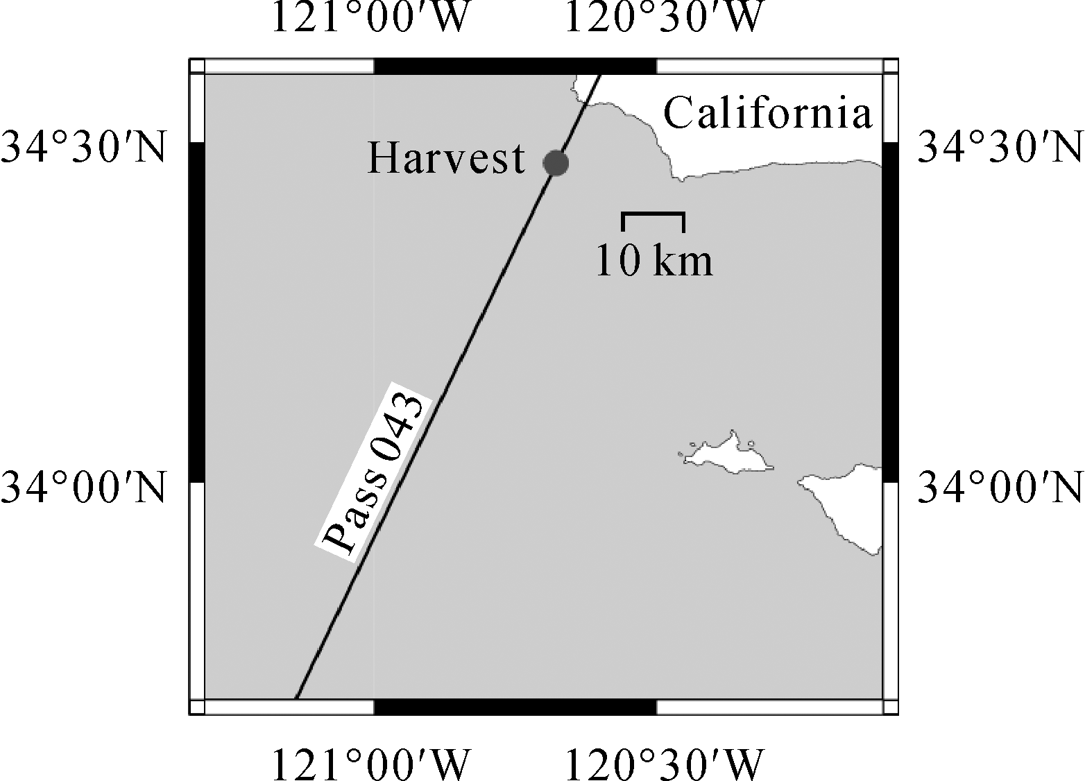
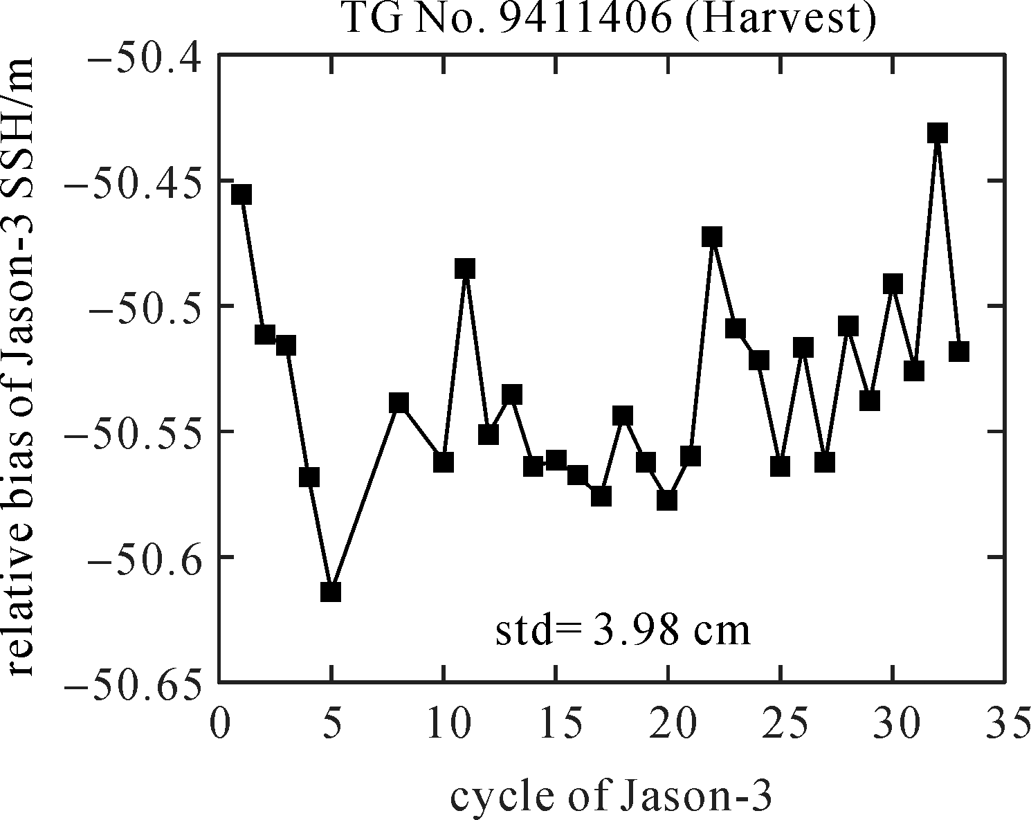
HAINES B, DESAI S, SHAH R , et al. The Harvest experiment: connecting Jason-3 to the long-term sea level record[R]//The Ocean Surface Topography Science Team Meeting 2016. La Rochelle, France: [s.n.], 2016.
|
| [22] |
WATSON C, LEGRESY B, KING M , et al. Altimeter absolute bias estimates from Bass Strait, Australia[R]//The Ocean Surface Topography Science Team Meeting 2016. La Rochelle, France: [s.n.], 2016.
|
| [23] |
BONNEFOND P, EXTERTIER P, LAURAIN O , et al. Corsica: a multi-mission absolute calibration site[R]//The Ocean Surface Topography Science Team Meeting 2016. La Rochelle, France: [s.n.], 2016.
|
| [24] |
MÉNARD Y, FU L L, ESCUDIER P , et al. The Jason-1 mission special issue:Jason-1 calibration/validation[J]. Marine geodesy, 2003,26(3-4):131-146. DOI: 10.1080/714044514.
|
| [25] |
DETTMERING D, SCHWATKE C . Global multi-mission crossover analysis: performance of Jason-3 and other new data sets[R] //The Ocean Surface Topography Science Team Meeting 2016. La Rochelle, France: [s.n.], 2016.
|