
Journal of Geodesy and Geoinformation Science ›› 2023, Vol. 6 ›› Issue (3): 102-114.doi: 10.11947/j.JGGS.2023.0310
• Literature Review • Previous Articles Next Articles
Xingxing LI1( ), Xiaohong ZHANG1, Xiaoji NIU1, Jian WANG2, Ling PEI3, Fangwen YU4, Hongjuan ZHANG1, Cheng YANG5, Zhouzheng GAO5, Quan ZHANG1, Feng ZHU1, Weisong WEN6, Tuan LI7,8, Jianchi LIAO9, Xin LI1
Received:2023-08-06
Accepted:2023-08-06
Online:2023-09-20
Published:2023-10-31
About author:Xingxing LI, male, professor, majors in GNSS precise data processing and its application for geoscience. E-mail: xingxingli@whu.edu.cn
Supported by:Xingxing LI, Xiaohong ZHANG, Xiaoji NIU, Jian WANG, Ling PEI, Fangwen YU, Hongjuan ZHANG, Cheng YANG, Zhouzheng GAO, Quan ZHANG, Feng ZHU, Weisong WEN, Tuan LI, Jianchi LIAO, Xin LI. Progress and Achievements of Multi-sensor Fusion Navigation in China during 2019—2023[J]. Journal of Geodesy and Geoinformation Science, 2023, 6(3): 102-114.
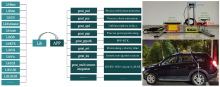
Fig.1
REAT software: satellite geodesy and multi-source navigation software and hardware platform"

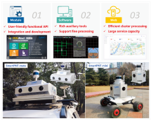
Fig.2
POSMind software system for PNT service"

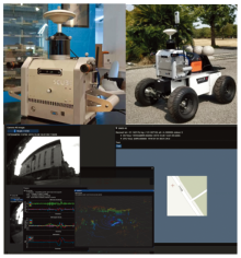
Fig.3
S-Cube: Plug-and-Play All-source Navigation Platform"


Fig.4
The application of multi-source fusion navigation from integrated & intelligent navigation group"


Fig.5
GNSS/INS tightly coupled navigation equipment and automatic driving applications"

| [1] |
OUYANG Wei, WU Yuanxin. Optimization-based strapdown attitude alignment for high-accuracy systems: covariance analysis with applications[J]. IEEE Transactions on Aerospace and Electronic systems, 2022, 58(5): 4053-4069.
doi: 10.1109/TAES.2022.3157570 |
| [2] |
ZHANG Quan, LI Shanshan, XU Zhengpeng, et al. Velocity-Based Optimization-Based Alignment (VBOBA) of low-end MEMS IMU/GNSS for low dynamic applications[J]. IEEE Sensors Journal, 2020, 20(10): 5527-5539.
doi: 10.1109/JSEN.7361 |
| [3] | HUANG Haoqian, WEI Jiaying, WANG Di, et al. In-motion initial alignment method based on vector observation and truncated vectorized K-matrix for SINS[J]. IEEE Transactions on Instrumentation and Measurement, 2022, 71: 3000415. |
| [4] |
HUANG Yulong, ZHANG Zheng, DU Siyuan, et al. A high-accuracy GPS-aided coarse alignment method for MEMS-based SINS[J]. IEEE Transactions on Instrumentation and Measurement, 2020, 69(10): 7914-7932.
doi: 10.1109/TIM.19 |
| [5] |
LIU Weiqian, CHENG Xianghong, DING Peng, et al. An optimal indirect in-motion coarse alignment method for GNSS-aided SINS[J]. IEEE Sensors Journal, 2022, 22(8): 7608-7618.
doi: 10.1109/JSEN.2022.3153093 |
| [6] |
CHEN Qijin, LIN Huan, GUO Ruonan, et al. Rapid and accurate initial alignment of the low-cost MEMS IMU chip dedicated for tilted RTK receiver[J]. GPS Solutions, 2020, 24(4): 119.
doi: 10.1007/s10291-020-01032-8 |
| [7] |
ZHANG Xiaohong, ZHU Feng, ZHANG Yuxi, et al. The improvement in integer ambiguity resolution with INS aiding for kinematic precise point positioning[J]. Journal of Geodesy, 2019, 93(7): 993-1010.
doi: 10.1007/s00190-018-1222-3 |
| [8] |
MA Liye, ZHU Feng, LIU Wanke, et al. VC-LAMBDA: a baseline vector constrained LAMBDA method for integer least-squares estimation[J]. Journal of Geodesy, 2022, 96(9): 59.
doi: 10.1007/s00190-022-01644-7 |
| [9] |
YANG Cheng, SHI Wenzhong, CHEN Wu. Robust M-M unscented Kalman filtering for GPS/IMU navigation[J]. Journal of Geodesy, 2019, 93(8): 1093-1104.
doi: 10.1007/s00190-018-01227-5 |
| [10] |
ZHANG Quan, CHEN Qijin, XU Zhengpeng, et al. Evaluating the navigation performance of multi-information integration based on low-end inertial sensors for precision agriculture[J]. Precision Agriculture, 2021, 22(3): 627-646.
doi: 10.1007/s11119-020-09747-x |
| [11] |
ZHANG Quan, HU Yuanqian, NIU Xiaoji. Required lever arm accuracy of non-holonomic constraint for land vehicle navigation[J]. IEEE Transactions on Vehicular Technology, 2020, 69(8): 8305-8316.
doi: 10.1109/TVT.25 |
| [12] |
ZHANG Quan, HU Yuanqian, LI Shanshan, et al. Mounting parameter estimation from velocity vector observations for land vehicle navigation[J]. IEEE Transactions on Industrial Electronics, 2022, 69(4): 4234-4244.
doi: 10.1109/TIE.2021.3075883 |
| [13] |
CHEN Qijin, ZHANG Quan, NIU Xiaoji. Estimate the pitch and heading mounting angles of the IMU for land vehicular GNSS/INS integrated system[J]. IEEE Transactions on Intelligent Transportation Systems, 2021, 22(10): 6503-6515.
doi: 10.1109/TITS.2020.2993052 |
| [14] |
WANG Liqiang, NIU Xiaoji, ZHANG Tisheng, et al. Accuracy and robustness of ODO/NHC measurement models for wheeled robot positioning[J]. Measurement, 2022, 201: 111720.
doi: 10.1016/j.measurement.2022.111720 |
| [15] |
OUYANG Wei, WU Yuanxin, CHEN Hongyue. INS/odometer land navigation by accurate measurement modeling and multiple-model adaptive estimation[J]. IEEE Transactions on Aerospace and Electronic Systems, 2021, 57(1): 245-262.
doi: 10.1109/TAES.7 |
| [16] |
GAO Zhouzheng, GE Maorong, LI You, et al. Modeling of multi-sensor tightly aided BDS triple-frequency precise point positioning and initial assessments[J]. Information Fusion, 2020, 55: 184-198.
doi: 10.1016/j.inffus.2019.08.012 |
| [17] |
WU Yibin, NIU Xiaoji, KUANG Jian. A comparison of three measurement models for the wheel-mounted MEMS IMU-based dead reckoning system[J]. IEEE Transactions on Vehicular Technology, 2021, 70(11): 11193-11203.
doi: 10.1109/TVT.2021.3102409 |
| [18] |
XU Qiaozhuang, GAO Zhouzheng, LV Jie, et al. Tightly coupled integration of BDS-3 B2b RTK, IMU, odometer, and dual-antenna attitude[J]. IEEE Internet of Things Journal, 2023, 10(7): 6415-6427.
doi: 10.1109/JIOT.2022.3227019 |
| [19] |
HU Jie, ZHU Feng, ZHUO Desheng, et al. Performance evaluation of stereo vision aided loosely coupled GNSS/SINS integration for land vehicle navigation in different urban environments[J]. IEEE Sensors Journal, 2023, 23(4): 4129-4142.
doi: 10.1109/JSEN.2023.3234216 |
| [20] |
NIU Xiaoji, TANG Hailiang, ZHANG Tisheng, et al. IC-GVINS: a robust, real-time, INS-centric GNSS-visual-inertial navigation system[J]. IEEE Robotics and Automation Letters, 2023, 8(1): 216-223.
doi: 10.1109/LRA.2022.3224367 |
| [21] |
LIAO Jianchi, LI Xingxing, WANG Xuanbin, et al. Enhancing navigation performance through visual-inertial odometry in GNSS-degraded environment[J]. GPS Solutions, 2021, 25(2): 50.
doi: 10.1007/s10291-020-01056-0 |
| [22] | XU Qiaozhuang, LV Jie, GAO Zhouzheng. Evaluation on low-cost GNSS/IMU/Vision integration system in GNSS-denied environments[C]// Proceedings of 2022 IEEE 12th International Conference on Indoor Positioning and Indoor Navigation. Beijing, China: IEEE, 2022: 1-6. |
| [23] |
LI Xingxing, LI Shengyu, ZHOU Yuxuan, et al. Continuous and precise positioning in urban environments by tightly coupled integration of GNSS, INS and vision[J]. IEEE Robotics and Automation Letters, 2022, 7(4): 11458-11465.
doi: 10.1109/LRA.2022.3201694 |
| [24] |
LI Xin, LI Xingxing, HUANG Jiaxin, et al. Improving PPP-RTK in urban environment by tightly coupled integration of GNSS and INS[J]. Journal of Geodesy, 2021, 95(12): 132.
doi: 10.1007/s00190-021-01578-6 |
| [25] |
LI Tao, PEI Ling, XIANG Yan, et al. P3-VINS: tightly-coupled PPP/INS/Visual SLAM based on optimization approach[J]. IEEE Robotics and Automation Letters, 2022, 7(3): 7021-7027.
doi: 10.1109/LRA.2022.3180441 |
| [26] |
JIANG Haitao, LI Tuan, SONG Dan, et al. An effective integrity monitoring scheme for GNSS/INS/vision integration based on error state EKF model[J]. IEEE Sensors Journal, 2022, 22(7): 7063-7073.
doi: 10.1109/JSEN.2022.3154054 |
| [27] | LI Tao, PEI Ling, XIANG Yan, et al. P3-LINS: tightly coupled PPP-GNSS/INS/LiDAR navigation system with effective initialization[J]. IEEE Transactions on Instrumentation and Measurement, 2023, 72: 8501813. |
| [28] |
LI Shengyu, WANG Shiwen, ZHOU Yuxuan, et al. Tightly coupled integration of GNSS, INS, and LiDAR for vehicle navigation in urban environments[J]. IEEE Internet of Things Journal, 2022, 9(24): 24721-24735.
doi: 10.1109/JIOT.2022.3194544 |
| [29] |
LI Shengyu, LI Xingxing, WANG Huidan, et al. Multi-GNSS PPP/INS/Vision/LiDAR tightly integrated system for precise navigation in urban environments[J]. Information Fusion, 2023, 90: 218-232.
doi: 10.1016/j.inffus.2022.09.018 |
| [30] |
ZHOU Jian, GUO Yuan, BIAN Yaoan, et al. Lane information extraction for high definition maps using crowdsourced data[J]. IEEE Transactions on Intelligent Transportation Systems, 2023, 24(7): 7780-7790.
doi: 10.1109/TITS.2022.3222504 |
| [31] |
XU Qingxu, ZHU Feng, HU Jie, et al. An enhanced positioning algorithm module for low-cost GNSS/MEMS integration based on matching straight lane lines in HD maps[J]. GPS Solutions, 2023, 27(1): 22.
doi: 10.1007/s10291-022-01362-9 |
| [32] |
NIU Xiaoji, PENG Yitang, DAI Yuhang, et al. Camera-based lane-aided multi-information integration for land vehicle navigation[J]. IEEE/ASME Transactions on Mechatronics, 2023, 28(1): 152-163.
doi: 10.1109/TMECH.2022.3192985 |
| [33] |
CONG Ming, ZOU Qiang, LIU Dong, et al. Review of robot navigation inspired by the localization cells’cognitive mechanism[J]. Journal of Mechanical Engineering, 2019, 55(23): 1-12.
doi: 10.3901/JME.2019.23.001 |
| [34] | YANG Chuang, LIU Jianye, XIONG Zhi, et al. Brain-inspired navigation technology integrating perception and action decision: a review and outlook[J]. Acta Aeronautica et Astronautica Sinica, 2020, 41(1): 023280. |
| [35] | GUO Chi, LUO Binhan, LI Fei, et al. Review and verification for brain-like navigation algorithm[J]. Geomatics and Information Science of Wuhan University, 2021, 46(12): 1819-1831. |
| [36] | LIU Jingnan, LUO Yarong, GUO Chi, et al. PNT intelligence and intelligent PNT[J]. Acta Geodaetica et Cartographica Sinica, 2022, 51(6): 811-828. DOI: 10.11947/j.AGCS.2022.20220152. |
| [37] |
MENG Zhilin, ZHAO Dongye, SI Bailu, et al. A survey on robot navigation based on mammalian spatial cognition[J]. Robot, 2023, 45(4): 496-512.
doi: 10.13973/j.cnki.robot.220077 |
| [38] |
GONG Ziyi, YU Fangwen. A plane-dependent model of 3D grid cells for representing both 2D and 3D spaces under various navigation modes[J]. Frontiers in Computational Neuroscience, 2021, 15: 739515.
doi: 10.3389/fncom.2021.739515 |
| [39] |
WANG Yihong, XU Xuying, PAN Xiaochuan, et al. Grid cell activity and path integration on 2-D manifolds in 3-D space[J]. Nonlinear Dynamics, 2021, 104(2): 1767-1780.
doi: 10.1007/s11071-021-06337-y |
| [40] |
HAN Kun, WU Dewei, LAI Lei. Model of generating grid cell based on difference Hebbian learning in brain-inspired navigation[J]. Systems Engineering and Electronics, 2020, 42(3): 674-679.
doi: 10.3969/j.issn.1001-506X.2020.03.023 |
| [41] |
WANG Jiru, YAN Rui, TANG Huajin. Multi-scale extension in an entorhinal-hippocampal model for cognitive map building[J]. Frontiers in Neurorobotics, 2021, 14: 592057.
doi: 10.3389/fnbot.2020.592057 |
| [42] | YANG Chuang, LIU Jianye, XIONG Zhi, et al. Brain-inspired vector navigation method based on model of multi-scale grid cells[J]. Journal of Chinese Inertial Technology, 2020, 28(2): 179-185. |
| [43] |
YANG Chuang, XIONG Zhi, LIU Jianye, et al. A path integration approach based on multiscale grid cells for large-scale navigation[J]. IEEE Transactions on Cognitive and Developmental Systems, 2022, 14(3): 1009-1020.
doi: 10.1109/TCDS.2021.3092609 |
| [44] |
ZENG Taiping, TANG Fengzhen, JI Daxiong, et al. NeuroBayes SLAM: neurobiologically inspired Bayesian integration of multisensory information for robot navigation[J]. Neural Networks, 2020, 126: 21-35.
doi: S0893-6080(20)30077-0 pmid: 32179391 |
| [45] | ZHAO Chenhao, WU Deiwei, HAN Kun, et al. Path integration model based on multi-scale grid cell[J]. Systems Engineering and Electronics, 2020, 43(10): 2961-2967. |
| [46] | ZHAO Chenhao, WU Dewei, HE Jing, et al. Navigation cognitive map construction based on improved Q-learning algorithm[J]. Journal of Air Force Engineering University (Natural Science Edition), 2020, 21(2): 53-60. |
| [47] |
ZHAO Dongye, ZHANG Zheng, LU Hong, et al. Learning cognitive map representations for navigation by sensory-motor integration[J]. IEEE Transactions on Cybernetics, 2022, 52(1): 508-521.
doi: 10.1109/TCYB.2020.2977999 |
| [48] |
ZOU Qiang, CONG Ming, LIU Dong, et al. Robotic episodic cognitive learning inspired by hippocampal spatial cells[J]. IEEE Robotics and Automation Letters, 2020, 5(4): 5573-5580.
doi: 10.1109/LSP.2016. |
| [49] |
YU Naigong, ZHAI Yujia, YUAN Yunhe, et al. A bionic robot navigation algorithm based on cognitive mechanism of hippocampus[J]. IEEE Transactions on Automation Science and Engineering, 2019, 16(4): 1640-1652.
doi: 10.1109/TASE.8856 |
| [50] | GU Yu, ZHAO Xiubin, DAI Chuanjin. Brain-like large-scale spatial vector navigation method based on grid cell model[J]. Control Theory & Applications, 2021, 38(12): 2094-2100. |
| [51] |
LIAO Yishen, YU Hejie, YU Naigong. A brain-like navigation method inspired by the spatial cells’ cognitive mechanism[J]. Computers and Electrical Engineering, 2022, 103: 108305.
doi: 10.1016/j.compeleceng.2022.108305 |
| [52] | CHEN Mengyuan, TIAN Dehong. Bionic SLAM algorithm based on multi-scale grid cell to place cell[J]. Journal of Computer-Aided Design & Computer Graphics, 2021, 33(5): 712-723. |
| [53] | ZHOU Yang, WU Dewei, SONG Yi, et al. Biological inspired goal-oriented navigation model based on spatial exploration and construction of cognitive map[J]. Journal of Electronics & Information Technology, 2023, 45(5): 1817-1823. |
| [54] |
CHAO Lixun, AUGENSTEIN P, ROENNAU A, et al. Brain inspired path planning algorithms for drones[J]. Frontiers in Neurorobotics, 2023, 17: 1111861.
doi: 10.3389/fnbot.2023.1111861 |
| [55] |
LI Xingxing, HAN Xinjuan, LI Xin, et al. GREAT-UPD: an open-source software for uncalibrated phase delay estimation based on multi-GNSS and multi-frequency observations[J]. GPS Solutions, 2021, 25(2): 66.
doi: 10.1007/s10291-020-01070-2 |
| [56] | WEN Weisong, ZHOU Yiyang, ZHANG Guohao, et al. UrbanLoco: a full sensor suite dataset for mapping and localization in urban scenes[C]// Proceedings of 2020 IEEE International Conference on Robotics and Automation. Paris, France: IEEE, 2020: 2310-2316. |
| [57] |
YIN Jie, LI Ang, LI Tao, et al. M2DGR: a multi-sensor and multi-scenario SLAM dataset for ground robots[J]. IEEE Robotics and Automation Letters, 2022, 7(2): 2266-2273.
doi: 10.1109/LRA.2021.3138527 |
| [58] |
YU Fangwen, SHANG Jianga, HU Youjian, et al. NeuroSLAM: a brain-inspired SLAM system for 3D environments[J]. Biological Cybernetics, 2019, 113(5): 515-545.
doi: 10.1007/s00422-019-00806-9 |
| [59] |
ZENG Taiping, SI Bailu. A brain-inspired compact cognitive mapping system[J]. Cognitive Neurodynamics, 2021, 15(1): 91-101.
doi: 10.1007/s11571-020-09621-6 pmid: 33786082 |
| [60] | LIU Kefei, CUI Xiaoxin, KUANG Yisong, et al. An all-neuron spiking 2-D path integration and map representation model implemented on neuromorphic chips[C]// Proceedings of 2022 IEEE 16th International Conference on Solid-State & Integrated Circuit Technology. Nanjing, China: IEEE, 2022: 1-3. |
| [61] |
TANG Huajin, YAN Rui, TAN K C. Cognitive navigation by neuro-inspired localization, mapping, and episodic memory[J]. IEEE Transactions on Cognitive and Developmental Systems, 2018, 10(3): 751-761.
doi: 10.1109/TCDS.2017.2776965 |
| [62] |
SHEN Chong, LIU Xiaochen, CAO Huiliang, et al. Brain-like navigation scheme based on MEMS-INS and place recognition[J]. Applied Sciences, 2019, 9(8): 1708.
doi: 10.3390/app9081708 |
| [63] |
ZOU Qiang, CONG Ming, LIU Dong, et al. A neurobiologically inspired mapping and navigating framework for mobile robots[J]. Neurocomputing, 2021, 460: 181-194.
doi: 10.1016/j.neucom.2021.07.025 |
| [64] |
LIU Dong, LYU Zhi, ZOU Qiang, et al. Robotic navigation based on experiences and predictive map inspired by spatial cognition[J]. IEEE/ASME Transactions on Mechatronics, 2022, 27(6): 4316-4326.
doi: 10.1109/TMECH.2022.3155614 |
| [65] |
HUA Tong, PEI Ling, LI Tao, et al. M2C-GVIO: motion manifold constraint aided GNSS-visual-inertial odometry for ground vehicles[J]. Satellite Navigation, 2023, 4(1): 13.
doi: 10.1186/s43020-023-00102-9 |
| [66] | HUA Tong, LI Tao, PEI Ling. PIEKF-VIWO: visual-inertial-wheel odometry using partial invariant extended Kalman filter[C]// Proceedings of 2023 IEEE International Conference on Robotics and Automation. London, UK: IEEE, 2023. |
| [67] |
LI Jinquan, PEI Ling, ZOU Danping, et al. Attention-SLAM: a visual monocular SLAM learning from human gaze[J]. IEEE Sensors Journal, 2021, 21(5): 6408-6420.
doi: 10.1109/JSEN.7361 |
| No related articles found! |
| Viewed | ||||||
|
Full text |
|
|||||
|
Abstract |
|
|||||