
Journal of Geodesy and Geoinformation Science ›› 2021, Vol. 4 ›› Issue (4): 97-112.doi: 10.11947/j.JGGS.2021.0408
Previous Articles Next Articles
Jingguo LYU( ),Xingbin YANG,Danlu ZHANG,Shan JIANG
Received:2021-02-28
Accepted:2021-08-30
Online:2021-12-20
Published:2023-05-17
About author:Jingguo LYU, male, PhD, majors in geo-informatics and photogrammetry.E-mail: Supported by:Jingguo LYU,Xingbin YANG,Danlu ZHANG,Shan JIANG. High-resolution Remote Sensing Image Semi-global Matching Method Considering Geometric Constraints of Connection Points and Image Texture Information[J]. Journal of Geodesy and Geoinformation Science, 2021, 4(4): 97-112.
Add to citation manager EndNote|Reference Manager|ProCite|BibTeX|RefWorks
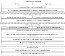
Fig.1
Flowchart of the DSM generation method of high resolution satellite stereo image"
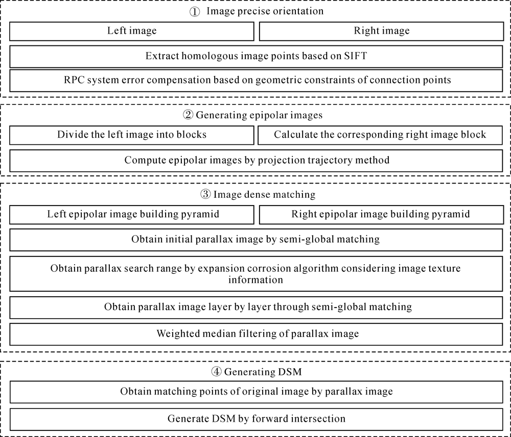
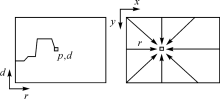
Fig.2
Accumulation of costs in parallax image"
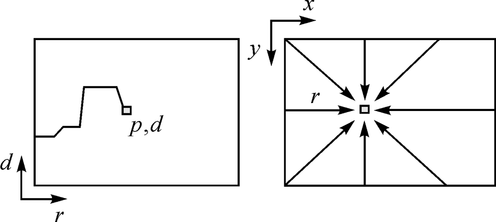

Fig.3
Contrast of tSGM and our method of parallax search range"
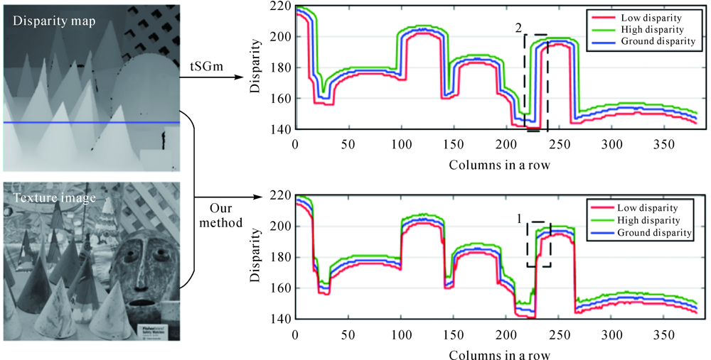
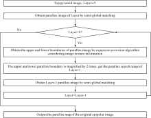
Fig.4
Flow chart of modified semi global matching"
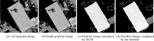
Fig.5
Parallax image computed by tSGM and our method"

Tab.1
Comparison of computing time"
| Image resolution 652×665 | Initial parallax search range/pixel | Calculation time of cost matrix/s | Calculation time of cost accumulation in 8 directions/s | Calculation time of optimal parallax selection /s | Total time/s |
|---|---|---|---|---|---|
| Our method | 32 | 0.14 | 0.93 | 0.085 | 1.15 |
| tSGM | 326 | 0.26 | 2.51 | 0.087 | 2.86 |
| SGM | 652 | 0.61 | 3.59 | 0.11 | 4.31 |

Fig.6
Stereoscopic of WorldView-3 and DSM"
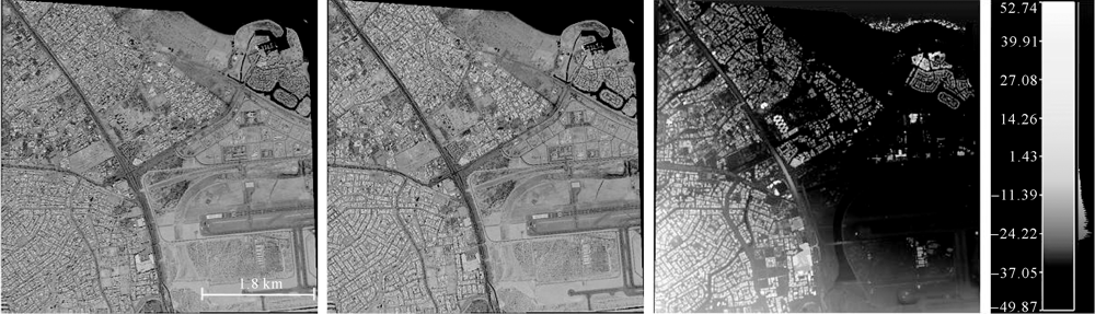
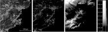
Fig.7
Stereoscopic images of ZY-3 and DSM"

Tab.2
Back projection errors of WorldView-3 stereo image"
| Error | Left image | Right image | ||
|---|---|---|---|---|
| Line | Column | Line | Colum | |
| Maximum | 0.3506 | 0.6534 | 0.3567 | 0.6903 |
| Average | 0.1693 | 0.3379 | 0.1761 | 0.3474 |
| Standard deviation | 0.1025 | 0.1690 | 0.1007 | 0.1803 |
Tab.3
Statistical analysis of Y-parallax values of epipolar image"
| Experimental area | Maximum absolute error | Average absolute error | Standard deviation error |
|---|---|---|---|
| Flat area | 0.6371 | 0.2820 | 0.1825 |
| Urban area | 0.7343 | 0.2973 | 0.3091 |
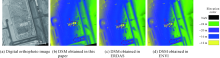
Fig.8
Comparison of DSM in the flat area"
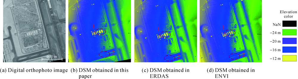
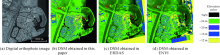
Fig.9
Comparison of DSM in the urban area"
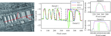
Fig.10
The elevation section of the building as well as superposition of details derived from three methods"

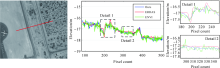
Fig.11
The elevation section of the flat road as well as superposition of details derived from three methods"
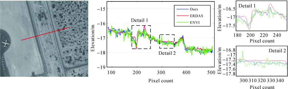
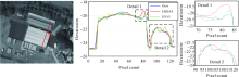
Fig.12
The elevation section of the shed as well as superposition of details derived from three methods"

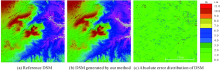
Fig.13
The absolute error distribution of DSM in the plain area"

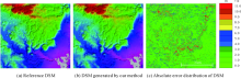
Fig.14
The absolute error distribution of DSM in the hilly area"

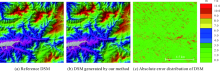
Fig.15
The absolute error distribution of DSM in the mountainous area"

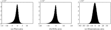
Fig.16
Elevation error histogram in different experimental areas"
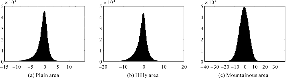
Tab.4
DSM accuracy evaluation results in different experimental areas"
| Experimental area | Elevation accuracy/m | ||
|---|---|---|---|
| Average error | Absolute mean error | Root mean squared errors | |
| Plain | -1.6 | 2.71 | 3.69 |
| Hilly | -1.71 | 3.22 | 4.66 |
| Mountainous | -1.18 | 3.96 | 5.62 |
Tab.5
Comparison results of calculation performance of three algorithms"
| Stereopair of Wordview3 12984×12928 | Input | Module function | Output | Memory cost/G | Calculation time/min |
|---|---|---|---|---|---|
| Our method | Stereopair after block adjustment | Dense matching and forward intersection | Dense point cloud | 5.46 | 11 |
| ENVI | Original Stereopair | Block adjustment,dense matching and forward intersection | Dense point cloud and DSM | 5.69 | 9 |
| ERDAS | Stereopair after block adjustment | Dense matching and forward intersection | Dense point cloud | 4.47 | 19 |
| [1] |
SCHARSTEIN D, SZELISKI R. A taxonomy and evaluation of dense two-frame stereo correspondence algorithms[J]. International Journal of Computer Vision, 2002, 47(1-3):7-42.
doi: 10.1023/A:1014573219977 |
| [2] | KOLMOGOROV V, MONASSE P, TAN P. Kolmogorov and Zabih’s graph cuts stereo matching algorithm[J]. Image Processing on Line, 2014(4):220-251. |
| [3] | FELZENSZWALB P F, HUTTENLOCHER D P. Efficient belief propagation for early vision[C]// Proceedings of 2004 IEEE Computer Society Conference on Computer Vision and Pattern Recognition. Washington, DC, USA:IEEE, 2004:261-268. |
| [4] | HIRSCHMULLER H. Accurate and efficient stereo processing by semi-global matching and mutual information[C]// Proceedings of 2005 IEEE Computer Society Conference on Computer Vision and Pattern Recognition. San Diego, CA, USA:IEEE, 2005:807-814. |
| [5] | D’ANGELO P. Improving semi-global matching:cost aggregation and confidence measure[J]. The International Archives of the Photogrammetry, Remote Sensing and Spatial Information Sciences, 2016,XLI- B1:299-304. |
| [6] | WENZEL K. Dense image matching for close range photogram-metry[D]. Stuttgart:University of Stuttgart, 2016. |
| [7] | ROTHERMEL M, WENZEL K, FRITSCH D, et al. SURE:photogrammetric surface reconstruction from imagery[C]// Proceedings of LC3D Workshop. Berlin:[s.n.], 2012. |
| [8] | KUSCHK G, D’ANGELO P, QIN R, et al. DSM accuracy evaluation for the ISPRS commission I image matching benchmark[J]. The International Archives of the Photogrammetry,Remote Sensing and Spatial Information Sciences, 2014,XL- 1:195-200. |
| [9] | D’ANGELO P. Evaluation of ZY-3 for DSM and ortho image generation[J]. International Archives of the Photogrammetry, Remote Sensing and Spatial Information Sciences, 2013, XL- 1/W1:57-61. |
| [10] | GHUFFAR S. Satellite stereo based digital surface model generation using semi global matching in object and image space[J]. ISPRS Annals of Photogrammetry, Remote Sensing and Spatial Information Sciences, 2016(3-1):63-68. |
| [11] | BETHMANN F, LUHMANN T. Semi-global matching in object space ISPRS-international Archives of the Photogrammetry, Remote Sensing and Spatial Information Sciences, 2015,XL- 3/W2:23-30. |
| [12] | LUHMANN T, BETHMANN F, HASTEDT H. Dense pointclouds from combined nadir and oblique imagery by object-based semi-global multi-image matching[D]. Oldenburg:Jade University of Applied Sciences, 2017. |
| [13] |
HIRSCHMULLER H. Stereo processing by semiglobal matching and mutual information[J]. IEEE Transactions on Pattern Analysis and Machine Intelligence, 2008, 30(2):328-341.
doi: 10.1109/TPAMI.2007.1166 |
| [14] | TATAR N, SAADATSERESHT M, AREFI H, et al. Quasi-epipolar resampling of high resolution satellite stereo imagery for semi global matching[J]. ISPRS-International Archives of the Photogrammetry, Remote Sensing and Spatial Information Sciences, 2015, XL-1- W5:707-712. |
| [15] | ZHANG Chunsen, LÜ Peiyu, GUO Bingxuan. Based GCP-SGM algorithm and its application in scene 3D reconstruction of archaeological excavation site[J]. Geomatics and Information Science of Wuhan University, 2015, 40(12):1575-1581. |
| [16] | ZHANG Yanfeng. Pixel-wise dense matching of aerial images with multi-conditional constraints[D]. Beijing:Chinese Academy of Surveying and Mapping, 2014. |
| [17] | ROTHERMEL M. Development of A SGM-based multi-view reconstruction framework for aerial imagery[D]. Stuttgart:University of Stuttgart, 2016. |
| [18] | GONG K, FRITSCH D. A detailed study about digital surface model generation using high resolution satellite stereo imagery[J]. ISPRS Annals of the Photogrammetry, Remote Sensing and Spatial Information Sciences, 2016(3-1):69-76. |
| [19] | YAN Li, FEI Liang, CHEN Changhai, et al. A multi-view dense matching algorithm of high resolution aerial images based on graph network[J]. Acta Geodaetica et Cartographica Sinica, 2016, 45(10):1171-1181. |
| [20] | LIU Jun, ZHANG Yongsheng, WANG Donghong. Precise positioning of high spatial resolution satellite images based on RPC models[J]. Acta Geodaetica et Cartographica Sinica, 2006, 35(1):30-34. |
| [21] | LI Deren, ZHANG Guo, JIANG Wanshou, et al. SPOT-5 HRS satellite imagery block adjustment without GCPS or with single GCP[J]. Geomatics and Information Science of Wuhan University, 2006, 31(5):377-381. |
| [22] | MORGAN M, KIM K O, JEONG S, et al. Epipolar resampling of space-borne linear array scanner scenes using parallel projection[J]. Photogrammetric Engineering & Remote Sensing, 2006, 72(11):1255-1263. |
| [23] | ZHANG Guo, PAN Hongbo, JIANG Wanshou, et al. Epipolar resampling and epipolar geometry reconstruction of linear array scanner scenes based on RPC model[J]. Remote Sensing for Land & Resources, 2010, 22(4):1-5. |
| [24] | HIRSCHMULLER H, SCHARSTEIN D. Evaluation of cost functions for stereo matching[C]// Proceedings of 2007 IEEE Conference on Computer Vision and Pattern Recognition. Minneapolis, MN, USA:IEEE, 2007:1-8. |
| [25] | HUMENBERGER M, ENGELKE T, KUBINGER W. A census-based stereo vision algorithm using modified semi-global matching and plane fitting to improve matching quality[C]// Proceedings of 2010 IEEE Computer Society Conference on Computer Vision and Pattern Recognition workshops. San Francisco, CA, USA:IEEE, 2010:77-84. |
| [26] | SPANGENBERG R, LANGNER T, ADFELDT S, et al. Large scale semi-global matching on the CPU[C]// Proceedings of 2014 IEEE Intelligent Vehicles Symposium. Dearborn, MI, USA:IEEE, 2014:195-201. |
| [27] | YUAN Xiuxiao, CAO Jinshan. Theory and method of precise object positioning of high resolution satellite imagery[M]. Beijing: Science Press, 2012:182-183. |
| [1] | Xingbin YANG, Jingguo LYU, Shan JIANG, Danlu ZHANG. High-resolution Remote Sensing Image Semi-global Matching Method Considering Geometric Constraints of Connection Points and Image Texture Information [J]. Journal of Geodesy and Geoinformation Science, 2022, 5(4): 86-101. |
| Viewed | ||||||
|
Full text |
|
|||||
|
Abstract |
|
|||||