
Journal of Geodesy and Geoinformation Science ›› 2024, Vol. 7 ›› Issue (3): 57-75.doi: 10.11947/j.JGGS.2024.0304
Previous Articles Next Articles
WANG Yuefeng1,2( ), JIAO Wei3
Published:2024-09-25
Online:2024-09-23
About author:WANG Yuefeng. E-mail: wangyuefeng2021@glut.edu.cn.
Supported by:WANG Yuefeng, JIAO Wei. Parameter-driven Level of Detail Derivation Method for Semantic Building Facade Model[J]. Journal of Geodesy and Geoinformation Science, 2024, 7(3): 57-75.
Add to citation manager EndNote|Reference Manager|ProCite|BibTeX|RefWorks
Table 1
The difference of eight popular data formats"
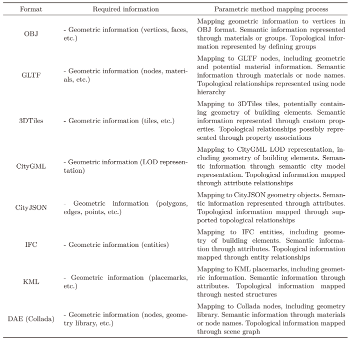 |
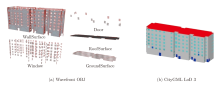
Figure 1
Representation of building semantic information in different data formats"

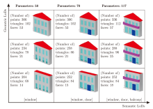
Figure 2
Representation for geometric and semantic LoDs"


Figure 3
Facade layout graph model"

Figure 4
Parameterized representation of semantic facade model"
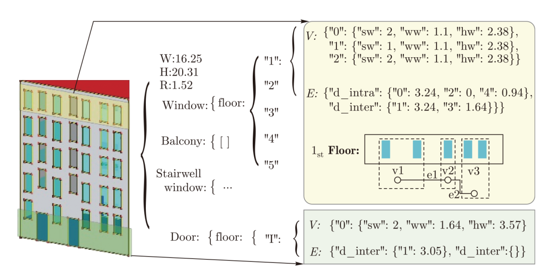
Table 2
Three LoDs of semantic facade model"
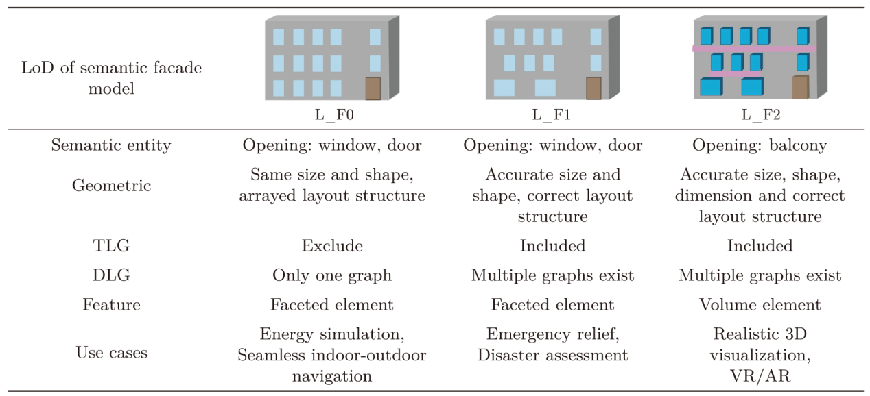 |
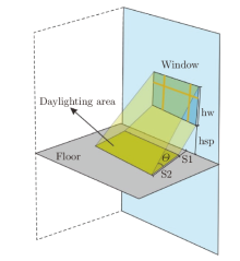
Figure 5
Calculation of building daylighting area"

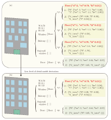
Figure 6
Parameter refinement process"


Figure 7
Experimental datasets"
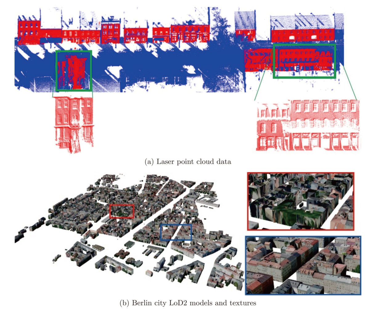

Figure 8
Reconstruction of semantic facade models from laser point cloud data and multi-LoDs derivation"
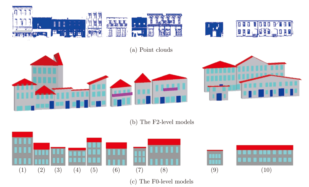
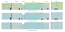
Figure 9
Multi-LoD derived from a complex facade model"


Figure 10
Simplification process of geometric and semantic LoDs in the semantic facade model"
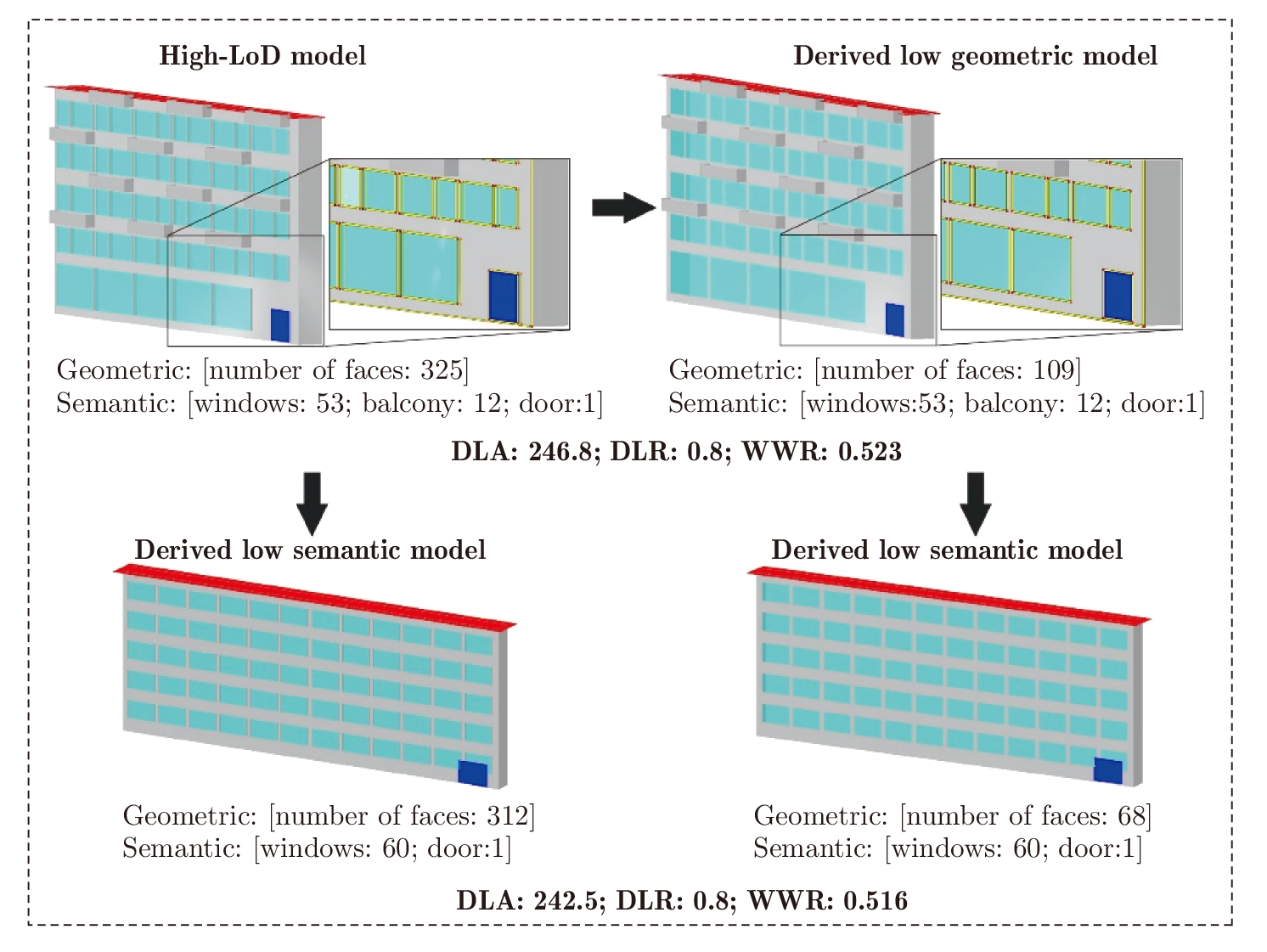

Figure 11
Reconstruction and derivation of semantic 3D building model with low-LoD based on CityGML LoD 2 models and corresponding texture images"
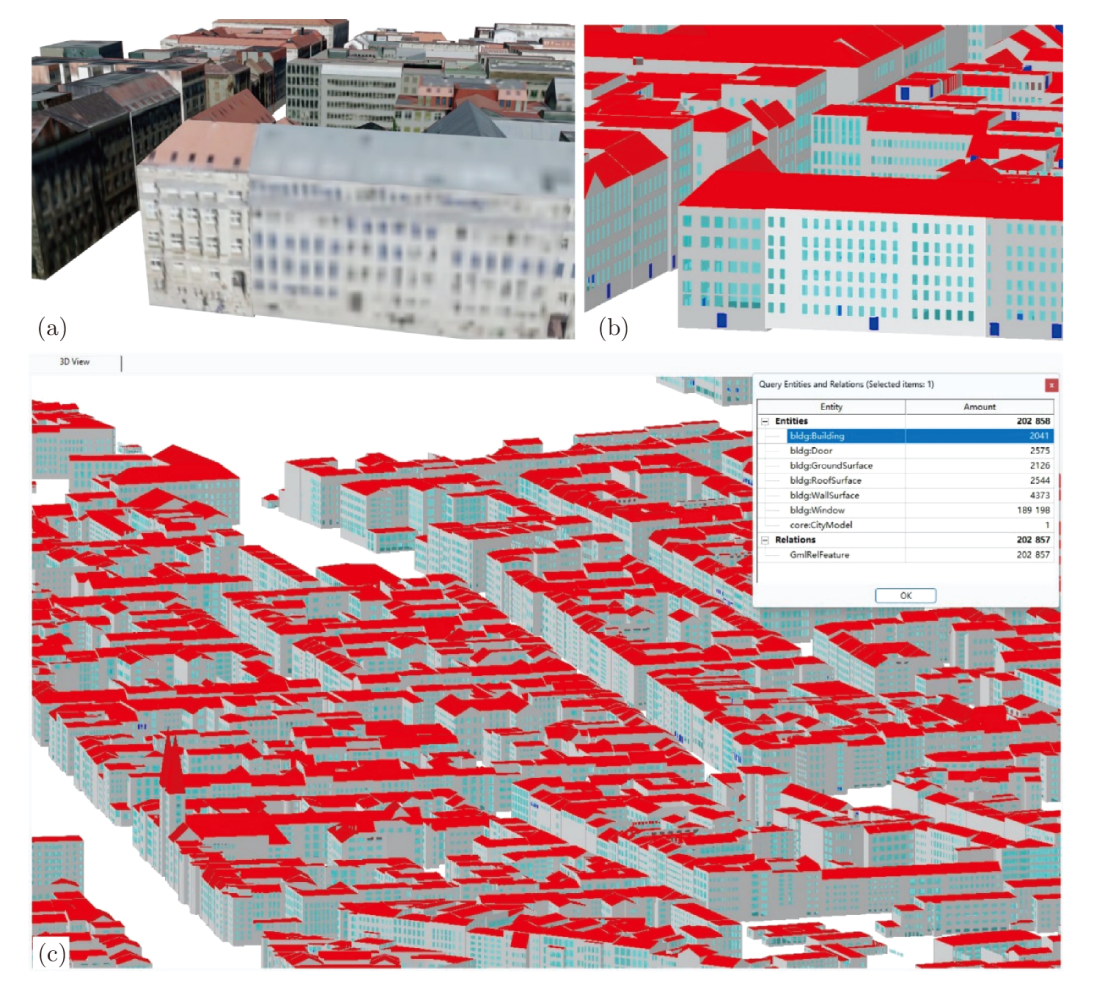
Table 3
The compression of facets and parameters of multi-LoD model"
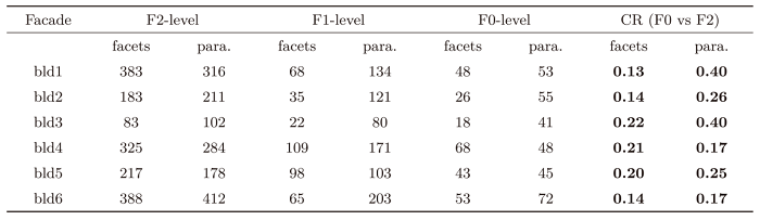 |
Table 4
IoU and accuracy scores of the experimental results in this section"
 |
| [1] | ZHU Yiqing, LI Nan. Virtual and augmented reality technologies for emergency management in the built environments: a state-of-the-art review[J]. Journal of Safety Science and Resilience, 2021, 2(1): 1-10. |
| [2] | BORTOLUZZI B, EFREMOV I, MEDINA C, et al. Automating the creation of building information models for existing buildings[J]. Automation in Construction, 2019, 105: 102838. |
| [3] | MAO Bo, HARRIE L, BAN Yifang. Detection and typification of linear structures for dynamic visualization of 3D city models[J]. Computers, Environment and Urban Systems, 2012, 36(3): 233-244. |
| [4] | TAKIKAWA T, LITALIEN J, YIN Kangxue, et al. Neural geometric level of detail: real-time rendering with implicit 3D shapes[C]// Proceedings of the IEEE/CVF Conference on Computer Vision and Pattern Recognition. Nashville, TN: IEEE, 2021: 11353-11362. |
| [5] | XU Zhihua, QU Lingling. A skeletal camera network for close-range images with a data driven approach in analyzing stereo configuration[J]. Journal of Geodesy and Geoinformation Science, 2022, 5(4): 23-37. DOI: 10.11947/j.JGGS.2022.0403. |
| [6] | HAN Jiali, ZHU Lingjie, GAO Xiang, et al. Urban scene LOD vectorized modeling from photogrammetry meshes[J]. IEEE Transactions on Image Processing, 2021, 30: 7458-7471. |
| [7] | ZHAO Zhiyao, FAN Hongchao. Towards exploring patterns of editing behavior on OpenStreetMap[J]. Journal of Geodesy and Geoinformation Science, 2022, 5(2): 85-97. DOI: 10.11947/j.JGGS.2022.0209. |
| [8] | ZHAO Junqiao, ZHU Qing, DU Zhiqiang, et al. Mathematical morphology-based generalization of complex 3D building models incorporating semantic relationships[J]. ISPRS Journal of Photogrammetry and Remote Sensing, 2012, 68: 95-111. |
| [9] | ZHANG Chenyang, HUANG Teng, SHEN Yueqian. A review of RGB-D camera calibration methods[J]. Journal of Geodesy and Geoinformation Science, 2021, 4(4): 11-33. DOI: 10.11947/j.JGGS.2021.0402. |
| [10] | ZHAN Wenxiao, CHEN Yuxuan, CHEN Jing. 3D tiles-based high-efficiency visualization method for complex BIM models on the web[J]. ISPRS International Journal of Geo-Information, 2021, 10(7): 476. |
| [11] | TEO T A, CHO K H. BIM-oriented indoor network model for indoor and outdoor combined route planning[J]. Advanced Engineering Informatics, 2016, 30(3): 268-282. |
| [12] | GOIA F. Search for the optimal window-to-wall ratio in office buildings in different European climates and the implications on total energy saving potential[J]. Solar Energy, 2016, 132: 467-492. |
| [13] | BOURHIM E M, CHERKAOUI A. Efficacy of virtual reality for studying people's pre-evacuation behavior under fire[J]. International Journal of Human-Computer Studies, 2020, 142: 102484. |
| [14] | PARK S, PARK S H, PARK L W, et al. Design and implementation of a smart IoT based building and town disaster management system in smart city infrastructure[J]. Applied Sciences, 2018, 8(11): 2239. |
| [15] | SHE Jiangfeng, CHEN Bo, TAN Junzhong, et al. 3D building model simplification method considering both model mesh and building structure[J]. Transactions in GIS, 2022, 26(3): 1182-1203. |
| [16] | XIANG Hanyu, HUANG Xianfeng, LAN Feng, et al. A shape-preserving simplification method for urban building models[J]. ISPRS International Journal of Geo-Information, 2022, 11(11): 562. |
| [17] | BILJECKI F, LEDOUX H, STOTER J, et al. Formalisation of the level of detail in 3D city modelling[J]. Computers, Environment and Urban Systems, 2014, 48: 1-15. |
| [18] | TANG Lei, YING Shen, LI Lin, et al. An application-driven LOD modeling paradigm for 3D building models[J]. ISPRS Journal of Photogrammetry and Remote Sensing, 2020, 161: 194-207. |
| [19] | DIXON S, IRSHAD H, PANKRATZ D M, et al. The 2019 Deloitte city mobility index[R]. [S.l.]: Deloitte Insights, 2019. |
| [20] | VON RICHTHOFEN A, HERTHOGS P, KRAFT M, et al. Semantic City Planning Systems (SCPS): a literature review[J]. Journal of Planning Literature, 2022, 37(3): 415-432. |
| [21] | ZHANG Xinchang, LI Shaoying, ZHOU Qiming, et al. Logical and innovative construction of digital twin city[J]. Journal of Geodesy and Geoinformation Science, 2021, 4(4): 113-120. DOI: 10.11947/j.JGGS.2021.0409. |
| [22] | NAPOLITANO R K, SCHERER G, GLISIC B. Virtual tours and informational modeling for conservation of cultural heritage sites[J]. Journal of Cultural Heritage, 2018, 29: 123-129. |
| [23] | TSCHIRSCHWITZ F, RICHERZHAGEN C, PRZYBILLA H J, et al. Duisburg 1566: transferring a historic 3D city model from Google earth into a virtual reality application[J]. PFG-Journal of Photogrammetry, Remote Sensing and Geoinformation Science, 2019, 87(1-2): 47-56. |
| [24] | ANAND P B. Assessing smart city projects and their implications for public policy in the Global South[J]. Contemporary Social Science, 2021, 16(2): 199-212. |
| [25] | DOCHEV I, GORZALKA P, WEILER V, et al. Calculating urban heat demands: an analysis of two modelling approaches and remote sensing for input data and validation[J]. Energy and Buildings, 2020, 226: 110378. |
| [26] | SANTANA J M, WENDEL J, TRUJILLO A, et al. Multimodal location based services—semantic 3D city data as virtual and augmented reality[M]//GARTNER G, HUANG Haosheng. Progress in Location-Based Services 2016. Cham: Springer, 2017: 329-353. |
| [27] | EL YAMANI S, ETTARID M, HAJJI R. Building information modeling potential for an enhanced real estate valuation approach based on the hedonic method[J]. WIT Transactions on the Built Environment, 2019, 192: 305-316. |
| [28] | CHATURVEDI K, WILLENBORG B, SINDRAM M, et al. Solar potential analysis and integration of the time-dependent simulation results for semantic 3D city models using dynamizers[C]// Proceedings of the 12th International 3D GeoInfo Conference 2017. Melbourne: ISPRS, 2017: 25-32. |
| [29] | RONG Youtong, ZHANG Ting, ZHENG Yanchen, et al. Three-dimensional urban flood inundation simulation based on digital aerial photogrammetry[J]. Journal of Hydrology, 2020, 584: 124308. |
| [30] | WANG Zhiyong, NIU Lei. A data model for using OpenStreetMap to integrate indoor and outdoor route planning[J]. Sensors, 2018, 18(7): 2100. |
| [31] | WALMSLEY A, KERSTEN T P. Low-cost development of an interactive, immersive virtual reality experience of the historic city model Stade 1620[C]// Proceedings of the 6th International Workshop LowCost 3D - Sensors, Algorithms, Applications. Strasbourg: ISPRS, 2019: 405-411. |
| [32] | WANG Yuefeng, FAN Hongchao, ZHOU Guoqing. Reconstructing facade semantic models using hierarchical topological graphs[J]. Transactions in GIS, 2020, 24(4): 1073-1097. |
| [33] | NYS G A, BILLEN R. From consistency to flexi-bility: handling spatial information schema thanks to a middleware in a 3D city modeling context[J]. Transactions in GIS, 2023, 27(1): 115-133. |
| [34] | PANTAZATOU K, KANTERS J, OLSSON P O, et al. Input data requirements for daylight simulations in urban densifications[J]. Urban Informatics, 2023, 2(1): 2. |
| [35] | State of New South Wales. Apartment design guide[S]. New South Wales: Housing and NSW Department of Planning and Environment, 2015. |
| [36] | HORTON D. Montana commercial energy code summary[S]. New South Wales: National Center for Appropriate Technology, 2015. |
| [37] | European Union. Amending energy performance of buildings directive (2018/844/EU)[S]. Belgium: Directorate-General for Energy of European Union, 2018. |
| [38] | Ministry of Housing and Urban-Rural Development of the People's Republic of China, General Administration of Quality Supervision, Inspection and Quarantine of the People's Republic of China. GB 50096-2011 design code for residential buildings[S]. Beijing: China Planning Press, 2012. |
| [39] | United Kingdom. Energy performance of buildings directive[S]. London: Ministry of Housing Communities & Local Government, United Kingdom Open Government Licence, 2018. |
| [40] | WAPC. R-Codes state planning policy 3.1 residential design codes[S]. Perth, Western Australia: Western Australian Planning Commission Department of Planning Lands and Heritage, 2018. |
| [41] | WANG Yanjun, LI Shaochun, WANG Mengjie, et al. A simple deep learning network for classification of 3D mobile LiDAR point clouds[J]. Journal of Geodesy and Geoinformation Science, 2021, 4(3): 49-59. DOI: 10.11947/j.JGGS.2021.0305. |
| [42] | FAN Hongchao, WANG Yuefeng, GONG Jianya. Layout graph model for semantic facade reconstruction using laser point clouds[J]. Geo-Spatial Information Science, 2021, 24(3): 403-421. |
| [43] | BILJECKI F, LEDOUX H, STOTER J. An improved LOD specification for 3D building models[J]. Computers, Environment and Urban Systems, 2016, 59: 25-37. |
| [44] | TAN Yi, LIANG Ying, ZHU Junxiang. CityGML in the integration of BIM and the GIS: challenges and opportunities[J]. Buildings, 2023, 13(7): 1758. |
| [45] | ZHU Junxiang, WANG Xiangyu, CHEN Meng-cheng, et al. Integration of BIM and GIS: IFC geometry transformation to shapefile using enhanced open-source approach[J]. Automation in Construction, 2019, 106: 102859. |
| No related articles found! |
| Viewed | ||||||
|
Full text |
|
|||||
|
Abstract |
|
|||||