
测绘学报(英文版) ›› 2023, Vol. 6 ›› Issue (3): 124-134.doi: 10.11947/j.JGGS.2023.0312
收稿日期:2023-08-23
接受日期:2023-09-15
出版日期:2023-09-20
发布日期:2023-10-31
Wei FENG1( ), Yuhao XIONG1, Shuang YI2, Bo ZHONG3, Xiaodong CHEN4, Yulong ZHONG5, Yuanjin PAN3, Lin LIU6, Wei WANG7, Min ZHONG1
Received:2023-08-23
Accepted:2023-09-15
Online:2023-09-20
Published:2023-10-31
About author:Wei FENG E-mail: fengwei@sysu.edu.cn
Supported by:. [J]. 测绘学报(英文版), 2023, 6(3): 124-134.
Wei FENG, Yuhao XIONG, Shuang YI, Bo ZHONG, Xiaodong CHEN, Yulong ZHONG, Yuanjin PAN, Lin LIU, Wei WANG, Min ZHONG. Recent Progress on Hydrogeodesy in China[J]. Journal of Geodesy and Geoinformation Science, 2023, 6(3): 124-134.
"

"

"

| [1] | YAO Yibin, YANG Yuanxi, SUN Heping, et al. Geodesy discipline: progress and perspective[J]. Acta Geodaetica et Cartographica Sinica, 2020, 49(10): 1243-1251. DOI: 10.11947/j.AGCS.2020.20200358. |
| [2] |
HEKI K, JIN Shuanggen. Geodetic study on earth surface loading with GNSS and GRACE[J]. Satellite Navigation, 2023, 4(1): 24.
doi: 10.1186/s43020-023-00113-6 |
| [3] |
RAMILLIEN G, FRAPPART F, CAZENAVE A, et al. Time variations of land water storage from an inversion of 2 years of GRACE geoids[J]. Earth and Planetary Science Letters, 2005, 235(1-2): 283-301.
doi: 10.1016/j.epsl.2005.04.005 |
| [4] | GRIPPA M, KERGOAT L, FRAPPART F, et al. Land water storage variability over West Africa estimated by Gravity Recovery and Climate Experiment (GRACE) and land surface models[J]. Water Resources Research, 2011, 47(5): W05549. |
| [5] | CHEN Jianli, FAMIGLIETT J S, SCANLON B R, et al. Groundwater storage changes: present status from GRACE observations[M]// CAZENAVEA, CHAMPOLLIONN, BENVENISTEJ, et al. Remote Sensing and Water Resources. Switzerland: Springer, 2016: 207-227. |
| [6] |
CASTELLAZZI P, MARTEL R, GALLOWAY D L, et al. Assessing groundwater depletion and dynamics using GRACE and InSAR: potential and limitations[J]. Groundwater, 2016, 54(6): 768-780.
doi: 10.1111/gwat.12453 pmid: 27576068 |
| [7] |
FENG Wei, ZHONG Min, LEMOINE J M, et al. Evaluation of groundwater depletion in North China using the Gravity Recovery and Climate Experiment (GRACE) data and ground-based measurements[J]. Water Resources Research, 2013, 49(4): 2110-2118.
doi: 10.1002/wrcr.v49.4 |
| [8] |
CAMPS A, PARK H, PABLOS M, et al. Sensitivity of GNSS-R spaceborne observations to soil moisture and vegetation[J]. IEEE Journal of Selected Topics in Applied Earth Observations and Remote Sensing, 2016, 9(10): 4730-4742.
doi: 10.1109/JSTARS.4609443 |
| [9] | SWENSON S, FAMIGLIETTI J, BASARA J, et al. Estimating profile soil moisture and groundwater variations using GRACE and Oklahoma Mesonet soil moisture data[J]. Water Resources Research, 2008, 44(1): W01413. |
| [10] |
MILZOW C, KROGH P E, BAUER-GOTTWEIN P. Combining satellite radar altimetry, SAR surface soil moisture and GRACE total storage changes for hydrological model calibration in a large poorly gauged catchment[J]. Hydrology and Earth System Sciences, 2011, 15(6): 1729-1743.
doi: 10.5194/hess-15-1729-2011 |
| [11] |
MUALA E, MOHAMED Y A, DUAN Zheng, et al. Estimation of reservoir discharges from Lake Nasser and Roseires Reservoir in the Nile Basin using satellite altimetry and imagery data[J]. Remote Sensing, 2014, 6(8): 7522-7545.
doi: 10.3390/rs6087522 |
| [12] |
TOURIAN M J, ELMI O, SHAFAGHI Y, et al. HydroSat: geometric quantities of the global water cycle from geodetic satellites[J]. Earth System Science Data, 2022, 14(5): 2463-2486.
doi: 10.5194/essd-14-2463-2022 |
| [13] |
WHITE A M, GARDNER W P, BORSA A A, et al. A review of GNSS/GPS in hydrogeodesy: hydrologic loading applications and their implications for water resource research[J]. Water Resources Research, 2022, 58(7): e2022WR032078.
doi: 10.1029/2022WR032078 |
| [14] | TAPLEY B D, FLECHTNER F, BETTADPUR S V, et al. The status and future prospect for GRACE after the first decade[C]// Proceeding of AGU Fall Meeting Abstracts. [S.l.]: AGU, 2013. |
| [15] |
CHEN Qiujie, SHEN Yunzhong, FRANCIS O, et al. Tongji-Grace02s and Tongji-Grace02k: high-precision static GRACE-only global earth’s gravity field models derived by refined data processing strategies[J]. Journal of Geophysical Research: Solid Earth, 2018, 123(7): 6111-6137.
doi: 10.1029/2018JB015641 |
| [16] |
LONG Di, SHEN Yanjun, SUN A, et al. Drought and flood monitoring for a large karst plateau in Southwest China using extended GRACE data[J]. Remote Sensing of Environment, 2014, 155: 145-160.
doi: 10.1016/j.rse.2014.08.006 |
| [17] | HOUBORG R, RODELL M, LI Bailing, et al. Drought indicators based on model-assimilated Gravity Recovery and Climate Experiment (GRACE) terrestrial water storage observations[J]. Water Resources Research, 2012, 48(7): W07525. |
| [18] |
LIU Xianfeng, FENG Xiaoming, CIAIS P, et al. GRACE satellite-based drought index indicating increased impact of drought over major basins in China during 2002—2017[J]. Agricultural and Forest Meteorology, 2020, 291: 108057.
doi: 10.1016/j.agrformet.2020.108057 |
| [19] |
MICHAILOVSKY C I, MCENNIS S, BERRY P A M, et al. River monitoring from satellite radar altimetry in the Zambezi River Basin[J]. Hydrology and Earth System Sciences, 2012, 16(7): 2181-2192.
doi: 10.5194/hess-16-2181-2012 |
| [20] | BIRKETT C M, MERTES L A K, DUNNE T, et al. Surface water dynamics in the Amazon Basin: application of satellite radar altimetry[J]. Journal of Geophysical Research: Atmospheres, 2002, 107(D20): LBA 26- 1-LBA 26-21. |
| [21] |
MATERNA K, FENG Lujia, LINDSEY E O, et al. GNSS characterization of hydrological loading in South and Southeast Asia[J]. Geophysical Journal International, 2021, 224(3): 1742-1752.
doi: 10.1093/gji/ggaa500 |
| [22] |
CASTELLAZZI P, ARROYO-DOMÍNGUEZ N, MARTEL R, et al. Land subsidence in major cities of Central Mexico: interpreting InSAR-derived land subsidence mapping with hydrogeological data[J]. International Journal of Applied Earth Observation and Geoinformation, 2016, 47: 102-111.
doi: 10.1016/j.jag.2015.12.002 |
| [23] | ZHOU Jiangcun, SUN Heping, XU Jianqiao. Validating global hydrological models by ground and space gravimetry[J]. Chinese Science Bulletin, 2009, 54(9): 1534-1542. |
| [24] |
SUN Yu, LI Yang, GUO Xiang, et al. Estimating C30 coefficients for GRACE/GRACE-FO time-variable gravity field models using the GRACE-OBP approach[J]. Journal of Geodesy, 2023, 97(3): 20.
doi: 10.1007/s00190-023-01707-3 |
| [25] |
SUN Yu, RIVA R, DITMAR P, et al. Using GRACE to explain variations in the earth’s oblateness[J]. Geophysical Research Letters, 2019, 46(1): 158-168.
doi: 10.1029/2018GL080607 |
| [26] |
SUN Yu, RIVA R E M. A global semi-empirical Glacial Isostatic Adjustment (GIA) model based on Gravity Recovery and Climate Experiment (GRACE) data[J]. Earth System Dynamics, 2020, 11(1): 129-137.
doi: 10.5194/esd-11-129-2020 |
| [27] |
YI Shuang, SNEEUW N. Filling the data gaps within GRACE missions using singular spectrum analysis[J]. Journal of Geophysical Research: Solid Earth, 2021, 126(5): e2020JB021227.
doi: 10.1029/2020JB021227 |
| [28] |
YI Shuang, SNEEUW N. A novel spatial filter to reduce north-south striping noise in GRACE spherical harmonic coefficients[J]. Journal of Geodesy, 2022, 96(4): 23.
doi: 10.1007/s00190-022-01614-z |
| [29] |
WANG Fengwei, SHEN Yunzhong, CHEN Qiujie, et al. Bridging the gap between GRACE and GRACE follow-on monthly gravity field solutions using improved multichannel singular spectrum analysis[J]. Journal of Hydrology, 2021, 594: 125972.
doi: 10.1016/j.jhydrol.2021.125972 |
| [30] |
ZHANG Chaoyang, SHUM C K, BEZDĚK A, et al. Rapid mass loss in West Antarctica revealed by swarm gravimetry in the absence of GRACE[J]. Geophysical Research Letters, 2021, 48(23): e2021GL095141.
doi: 10.1029/2021GL095141 |
| [31] | ZHONG Yulong, ZHONG Min, FENG Wei, et al. Evaluation of the evapotranspiration in the West Liaohe River Basin based on GRACE satellite and in situ measurements[J]. Geomatics and Information Science of Wuhan University, 2020, 45(2): 173-178. |
| [32] | ZHONG Bo, LI Qiong, CHEN Jianli, et al. A dataset of GRACE intersatellite geopotential differences from April, 2002 to July, 2016[J]. China Scientific Data, 2022, 7(2): 157-166. |
| [33] |
ZHONG Bo, LI Qiong, CHEN Jianli, et al. Improved estimation of regional surface mass variations from GRACE intersatellite geopotential differences using a priori constraints[J]. Remote Sensing, 2020, 12(16): 2553.
doi: 10.3390/rs12162553 |
| [34] |
ZHONG Bo, TAN Jiangtao, LI Qiong, et al. Simulation analysis of regional surface mass anomalies inversion based on different types of constraints[J]. Geodesy and Geodynamics, 2021, 12(4): 298-307.
doi: 10.1016/j.geog.2021.06.002 |
| [35] |
ZHONG Bo, LI Qiong, LI Xianpao, et al. Basin-scale terrestrial water storage changes inferred from GRACE-based geopotential differences: a case study of the Yangtze River Basin, China[J]. Geophysical Journal International, 2023, 233(2): 1318-1338.
doi: 10.1093/gji/ggac524 |
| [36] |
FERREIRA V G, YONG B, TOURIAN M J, et al. Characterization of the hydro-geological regime of Yangtze River basin using remotely-sensed and modeled products[J]. Science of the Total Environment, 2020, 718: 137354.
doi: 10.1016/j.scitotenv.2020.137354 |
| [37] |
ZHONG Yulong, ZHONG Min, MAO Yuna, et al. Evaluation of evapotranspiration for exorheic catchments of China during the GRACE era: from a water balance perspective[J]. Remote Sensing, 2020, 12(3): 511.
doi: 10.3390/rs12030511 |
| [38] |
BAI Hongbing, MING Zutao, ZHONG Yulong, et al. Evaluation of evapotranspiration for exorheic basins in China using an improved estimate of terrestrial water storage change[J]. Journal of Hydrology, 2022, 610: 127885.
doi: 10.1016/j.jhydrol.2022.127885 |
| [39] |
QU Wei, JIN Zehui, ZHANG Qin, et al. Estimation of evapotranspiration in the yellow river basin from 2002 to 2020 based on GRACE and GRACE follow-on observations[J]. Remote Sensing, 2022, 14(3): 730.
doi: 10.3390/rs14030730 |
| [40] |
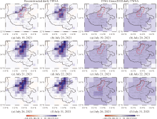
XIAO Cuiyu, ZHONG Yulong, FENG Wei, et al. Monitoring the catastrophic flood with GRACE-FO and near-real-time precipitation data in northern Henan Province of China in July 2021[J]. IEEE Journal of Selected Topics in Applied Earth Observations and Remote Sensing, 2023, 16: 89-101.
doi: 10.1109/JSTARS.2022.3223790 |
| [41] |
XIE Jingkai, XU Yueping, YU Hongjie, et al. Monitoring the extreme flood events in the Yangtze River basin based on GRACE and GRACE-FO satellite data[J]. Hydrology and Earth System Sciences, 2022, 26(22): 5933-5954.
doi: 10.5194/hess-26-5933-2022 |
| [42] |
XIONG Jinghua, YIN Jiabo, GUO Shenglian, et al. Integrated flood potential index for flood monitoring in the GRACE era[J]. Journal of Hydrology, 2021, 603: 127115.
doi: 10.1016/j.jhydrol.2021.127115 |
| [43] |
ZHANG Bao, LIU Lin, YAO Yibin, et al. Improving the estimate of the secular variation of Greenland ice mass in the recent decades by incorporating a stochastic process[J]. Earth and Planetary Science Letters, 2020, 549: 116518.
doi: 10.1016/j.epsl.2020.116518 |
| [44] |
SU Xiaoli, GUO Junyi, SHUM C K, et al. Increased low degree spherical harmonic influences on polar ice sheet mass change derived from GRACE mission[J]. Remote Sensing, 2020, 12(24): 4178.
doi: 10.3390/rs12244178 |
| [45] |
RAN Jiangjun, DITMAR P, LIU Lin, et al. Analysis and mitigation of biases in Greenland ice sheet mass balance trend estimates from GRACE mascon products[J]. Journal of Geophysical Research: Solid Earth, 2021, 126(7): e2020JB020880.
doi: 10.1029/2020JB020880 |
| [46] |
LIU Bingshi, ZOU Xiancai, YI Shuang, et al. Reconstructing GRACE-like time series of high mountain glacier mass anomalies[J]. Remote Sensing of Environment, 2022, 280: 113177.
doi: 10.1016/j.rse.2022.113177 |
| [47] |
LI Wenhao, SHUM C K, LI Fei, et al. Contributions of greenland GPS observed deformation from multisource mass loading induced seasonal and transient signals[J]. Geophysical Research Letters, 2020, 47(15): e2020GL088627.
doi: 10.1029/2020GL088627 |
| [48] |
WANG Ziyun, ZHANG Bao, YAO Yibin, et al. GRACE and mass budget method reveal decelerated ice loss in east Greenland in the past decade[J]. Remote Sensing of Environment, 2023, 286: 113450.
doi: 10.1016/j.rse.2023.113450 |
| [49] |
CHEN Qiujie, WANG Fengwei, SHEN Yunzhong, et al. Monthly gravity field solutions from early LEO satellites’observations contribute to global ocean mass change estimates over 1993—2004[J]. Geophysical Research Letters, 2022, 49(21): e2022GL099917.
doi: 10.1029/2022GL099917 |
| [50] |
LI Zhen, ZHANG Zizhan, SCANLON B R, et al. Combining GRACE and satellite altimetry data to detect change in sediment load to the Bohai Sea[J]. Science of the Total Environment, 2022, 818: 151677.
doi: 10.1016/j.scitotenv.2021.151677 |
| [51] |
WANG Fengwei, SHEN Yunzhong, CHEN Qiujie, et al. Revisiting sea-level budget by considering all potential impact factors for global mean sea-level change estimation[J]. Scientific Reports, 2022, 12(1): 10251.
doi: 10.1038/s41598-022-14173-2 pmid: 35715517 |
| [52] |
WANG Qiuyu, YI Shuang, SUN Wenke. Continuous estimates of glacier mass balance in high mountain Asia based on ICESat-1,2 and GRACE/GRACE follow-on data[J]. Geophysical Research Letters, 2021, 48(2): e2020GL090954.
doi: 10.1029/2020GL090954 |
| [53] |
SHEN Cong, JIA Li, REN Shaoting. Inter- and intra-annual glacier elevation change in high mountain asia region based on ICESat-1&2 data using elevation-aspect bin analysis method[J]. Remote Sensing, 2022, 14(7): 1630.
doi: 10.3390/rs14071630 |
| [54] |
FAN Yubin, KE Changqing, ZHOU Xiaobing, et al. Glacier mass-balance estimates over High Mountain Asia from 2000 to 2021 based on ICESat-2 and NASADEM[J]. Journal of Glaciology, 2023, 69(275): 500-512.
doi: 10.1017/jog.2022.78 |
| [55] |
ZHAO Fanyu, LONG Di, LI Xingdong, et al. Rapid glacier mass loss in the Southeastern Tibetan Plateau since the year 2000 from satellite observations[J]. Remote Sensing of Environment, 2022, 270: 112853.
doi: 10.1016/j.rse.2021.112853 |
| [56] |
WANG Qiuyu, SUN Wenke. Seasonal cycles of high mountain Asia glacier surface elevation detected by ICESat-2[J]. Journal of Geophysical Research: Atmospheres, 2022, 127(23): e2022JD037501.
doi: 10.1029/2022JD037501 |
| [57] |
LI Xianpao, ZHONG Bo, LI Jiancheng, et al. Analysis of terrestrial water storage changes in the Shaan-Gan-Ning Region using GPS and GRACE/GFO[J]. Geodesy and Geodynamics, 2022, 13(2): 179-188.
doi: 10.1016/j.geog.2021.11.001 |
| [58] |
LI Xianpao, ZHONG Bo, LI Jiancheng, et al. Inversion of terrestrial water storage changes from GNSS vertical displacements using a priori constraint: a case study of the Yunnan Province, China[J]. Journal of Hydrology, 2023, 617: 129126.
doi: 10.1016/j.jhydrol.2023.129126 |
| [59] | LI Xianpao, ZHONG Bo, LIU Tao. Simulation analysis of inverting regional surface mass variations using GNSS vertical displacement[J]. Geomatics and Information Science of Wuhan University, 2022, 47(1): 45-54. |
| [60] |
JIANG Zhongshan, HSU Y, YUAN Linguo, et al. Characterizing spatiotemporal patterns of terrestrial water storage variations using GNSS vertical data in Sichuan, China[J]. Journal of Geophysical Research: Solid Earth, 2021, 126(12): e2021JB022398.
doi: 10.1029/2021JB022398 |
| [61] |
WANG Wei, ZHANG Chuanyin, LIANG Shiming, et al. Monitoring of the temporal and spatial variation of groundwater storage in the Three Gorges area based on the CORS network[J]. Journal of Applied Geophysics, 2017, 146: 160-166.
doi: 10.1016/j.jappgeo.2017.09.008 |
| [62] |
LI Wanqiu, ZHANG Chuanyin, WANG Wei, et al. Inversion of regional groundwater storage changes based on the fusion of GNSS and GRACE data: a case study of Shaanxi-Gansu-Ningxia[J]. Remote Sensing, 2023, 15(2): 520.
doi: 10.3390/rs15020520 |
| [63] |
WANG Songyun, LI Jin, CHEN Jianli, et al. On the improvement of mass load inversion with GNSS horizontal deformation: a synthetic study in Central China[J]. Journal of Geophysical Research: Solid Earth, 2022, 127(10): e2021JB023696.
doi: 10.1029/2021JB023696 |
| [64] |
PAN Yuanjin, CHEN Ruizhi, YI Shuang, et al. Contemporary mountain-building of the Tianshan and its relevance to geodynamics constrained by integrating GPS and GRACE measurements[J]. Journal of Geophysical Research: Solid Earth, 2019, 124(11): 12171-12188.
doi: 10.1029/2019JB017566 |
| [65] |
PAN Yuanjin, JIANG Weiping, DING Hao, et al. Intradecadal fluctuations and three-dimensional crustal kinematic deformation of the Tianshan and pamir derived from multi-geodetic imaging[J]. Journal of Geophysical Research: Solid Earth, 2023, 128(1): e2022JB025325.
doi: 10.1029/2022JB025325 |
| [66] |
PAN Yuanjin, HAMMOND W C, DING Hao, et al. GPS imaging of vertical bedrock displacements: quantification of two-dimensional vertical crustal deformation in China[J]. Journal of Geophysical Research: Solid Earth, 2021, 126(4): e2020JB020951.
doi: 10.1029/2020JB020951 |
| [67] |
JIAO Jiashuang, ZHANG Yongzhi, YIN Peng, et al. Changing Moho beneath the Tibetan Plateau revealed by GRACE observations[J]. Journal of Geophysical Research: Solid Earth, 2019, 124(6): 5907-5923.
doi: 10.1029/2018JB016334 |
| [68] |
TANG Wei, ZHAO Xiangjun, MOTAGH M, et al. Land subsidence and rebound in the Taiyuan Basin, northern China, in the context of inter-basin water transfer and groundwater management[J]. Remote Sensing of Environment, 2022, 269: 112792.
doi: 10.1016/j.rse.2021.112792 |
| [69] |
SHI Guoqiang, MA Peifeng, HU Xie, et al. Surface response and subsurface features during the restriction of groundwater exploitation in Suzhou (China) inferred from decadal SAR interferometry[J]. Remote Sensing of Environment, 2021, 256: 112327.
doi: 10.1016/j.rse.2021.112327 |
| [70] |
SHI Xuguo, ZHU Tongtong, TANG WEI, et al. Inferring decelerated land subsidence and groundwater storage dynamics in Tianjin-Langfang using Sentinel-1 InSAR[J]. International Journal of Digital Earth, 2022, 15(1): 1526-1546.
doi: 10.1080/17538947.2022.2122610 |
| [71] |
ZHAO Yizhan, ZHOU Lv, WANG Cheng, et al. Analysis of the spatial and temporal evolution of land subsidence in Wuhan, China from 2017 to 2021[J]. Remote Sensing, 2022, 14(13): 3142.
doi: 10.3390/rs14133142 |
| [72] |
FENG Wei, SHUM C K, ZHONG Min, et al. Groundwater storage changes in China from satellite gravity: an overview[J]. Remote Sensing, 2018, 10(5): 674.
doi: 10.3390/rs10050674 |
| [73] |
BAI Lin, JIANG Liming, ZHAO Yong, et al. Quantifying the influence of long-term overexploitation on deep groundwater resources across Cangzhou in the North China Plain using InSAR measurements[J]. Journal of Hydrology, 2022, 605: 127368.
doi: 10.1016/j.jhydrol.2021.127368 |
| [74] |
CHEN Jie, WU Tonghua, LIU Lin, et al. Increased water content in the active layer revealed by regional-scale InSAR and independent component analysis on the central Qinghai-Tibet Plateau[J]. Geophysical Research Letters, 2022, 49(15): e2021GL097586.
doi: 10.1029/2021GL097586 |
| [75] |
WANG Lingxiao, ZHAO Lin, ZHOU Huayun, et al. Contribution of ground ice melting to the expansion of Selin Co (lake) on the Tibetan Plateau[J]. The Cryosphere, 2022, 16(7): 2745-2767.
doi: 10.5194/tc-16-2745-2022 |
| [76] |
ZHANG Zhiyu, GUO Fei, ZHANG Xiaohong. Triple-frequency multi-GNSS reflectometry snow depth retrieval by using clustering and normalization algorithm to compensate terrain variation[J]. GPS Solutions, 2020, 24(2): 52.
doi: 10.1007/s10291-020-0966-4 |
| [77] |
WAN Wei, ZHANG Jie, DAI Liyun, et al. A new snow depth data set over northern China derived using GNSS interferometric reflectometry from a continuously operating network (GSnow-CHINA v1.0, 2013-2022)[J]. Earth System Science Data, 2022, 14(8): 3549-3571.
doi: 10.5194/essd-14-3549-2022 |
| [78] |
HE Qianqian, CHEN Xiaodong, SUN Heping, et al. Quantitative separation of the local vadose zone water storage changes using the superconductive gravity technique[J]. Journal of Hydrology, 2022, 609: 127734.
doi: 10.1016/j.jhydrol.2022.127734 |
| [79] |
XING Lelin, NIU Xiaowei, BAI Lei, et al. Monitoring groundwater storage changes in a Karst aquifer using superconducting gravimeter OSG-066 at the Lijiang station in China[J]. Pure and Applied Geophysics, 2022, 179(5): 1853-1870.
doi: 10.1007/s00024-022-03024-w |
| [80] |
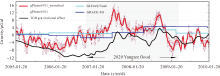
WANG Linsong, PENG Zhenran, MA Xian, et al. Multiscale gravity measurements to characterize 2020 flood events and their spatio-temporal evolution in Yangtze river of China[J]. Journal of Hydrology, 2021, 603: 127176.
doi: 10.1016/j.jhydrol.2021.127176 |
| [81] |
WANG Linsong, KABAN M K, THOMAS M, et al. The challenge of spatial resolutions for GRACE-based estimates volume changes of larger man-made lake: the case of China’s Three Gorges Reservoir in the Yangtze River[J]. Remote Sensing, 2019, 11(1): 99.
doi: 10.3390/rs11010099 |
| [82] |
MA Xian, WANG Linsong, CHEN Chao, et al. Simulation of the dynamic water storage and its gravitational effect in the head region of Three Gorges reservoir using imageries of Gaofen-1[J]. Remote Sensing, 2020, 12(20): 3353.
doi: 10.3390/rs12203353 |
| [83] |
WANG Linsong, CHEN Chao, MA Xian, et al. Evaluation of GRACE mascon solutions using in-situ geodetic data: the case of hydrologic-induced crust displacement in the Yangtze River Basin[J]. Science of the Total Environment, 2020, 707: 135606.
doi: 10.1016/j.scitotenv.2019.135606 |
| [84] | HAAGMANS R, TSAOUSSI L. Next Generation Gravity Mission as a Mass-change And Geosciences International Constellation (MAGIC) Mission Requirements Document[EB/OL]. [2023-06-01]. https://doi.org/10.5270/esa.nasa.magic-mrd.2020. |
| [85] |
PAVELSKY T M, DURAND M T, ANDREADIS K M, et al. Assessing the potential global extent of SWOT river discharge observations[J]. Journal of Hydrology, 2014, 519: 1516-1525.
doi: 10.1016/j.jhydrol.2014.08.044 |
| No related articles found! |
| 阅读次数 | ||||||
|
全文 |
|
|||||
|
摘要 |
|
|||||