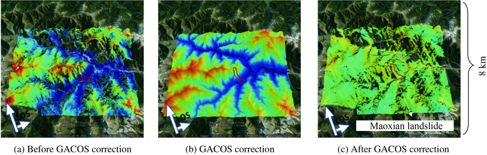
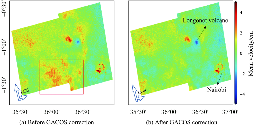
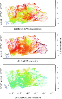
| [1] |
FENG Wanpeng, SAMSONOV S, LI Peng, et al. Coseismic and early-postseismic displacements of the 2015 MW8.3 Illapel (Chile) earthquake imaged by Sentinel-1a and RADARSAT-2[C]// 2016 IEEE International Geoscience and Remote Sensing Symposium. Beijing: IEEE, 2016.
|
| [2] |
LAU N, TYMOFYEYEVA E, FIALKO Y. Variations in the long-term uplift rate due to the Altiplano-Puna magma body observed with Sentinel-1 interferometry[J]. Earth and Planetary Science Letters, 2018,491:43-47.
|
| [3] |
MASSONNET D, FEIGL K L. Radar interferometry and its application to changes in the Earth’s surface[J]. Reviews of Geophysics, 1998,36(4):441-500.
|
| [4] |
FERRETTI A, PRATI C, ROCCA F. Permanent scatterers in SAR interferometry. IEEE Transactions on Geoscience and Remote Sensing, 2001,39(1):8-20.
|
| [5] |
FRUNEAU B, SARTI F. Detection of ground subsidence in the city of Paris using radar interferometry: isolation of deformation from atmospheric artifacts using correlation[J]. Geophysical Research Letters, 2000,27(24):3981-3984.
|
| [6] |
HOOPER A, ZEBKER H, SEGALL P, et al. A new method for measuring deformation on volcanoes and other natural terrains using InSAR persistent scatterers[J]. Geophysical Research Letters, 2004,31(23):L23611.
|
| [7] |
WILLIAMS S, BOCK Y, FANG P. Integrated satellite interferometry: tropospheric noise, GPS estimates and implications for interferometric synthetic aperture radar products[J]. Journal of Geophysical Research: Solid Earth, 1998,103(B11):27051-27067.
|
| [8] |
LI Zhenhong, MULLER J P, CROSS P, et al. Interferometric synthetic aperture radar (InSAR) atmospheric correction: GPS, Moderate Resolution Imaging Spectroradiometer (MODIS), and InSAR integration[J]. Journal of Geophysical Research: Solid Earth, 2005,110(B3):B03410.
|
| [9] |
LI Zhenhong, MULLER J P, CROSS P. Comparison of precipitable water vapor derived from radiosonde, GPS, and Moderate-Resolution Imaging Spectroradiometer measurements[J]. Journal of Geophysical Research: Atmospheres, 2003,108(D20):4651.
|
| [10] |
LI Zhenhong, FIELDING E J, CROSS P, et al. Interferometric synthetic aperture radar atmospheric correction: GPS topography-dependent turbulence model[J]. Journal of Geophysical Research: Solid Earth, 2006,111(B2):B02404.
|
| [11] |
LI Zhenhong, FIELDING E J, CROSS P. Integration of InSAR time-series analysis and water-vapor correction for mapping postseismic motion after the 2003 bam (Iran) earthquake[J]. IEEE Transactions on Geoscience and Remote Sensing, 2009,47(9):3220-3230.
|
| [12] |
LI Z, MULLER J P, CROSS P, et al. Assessment of the potential of MERIS near-infrared water vapour products to correct ASAR interferometric measurements[J]. International Journal of Remote Sensing, 2006,27(2):349-365.
|
| [13] |
ONN F, ZEBKER H A. Correction for interferometric synthetic aperture radar atmospheric phase artifacts using time series of zenith wet delay observations from a GPS network[J]. Journal of Geophysical Research: Solid Earth, 2006,111(B9):B09102.
|
| [14] |
XU W B, LI Z W, DING X L, et al. Interpolating atmospheric water vapor delay by incorporating terrain elevation information[J]. Journal of Geodesy, 2011,85(9):555-564.
|
| [15] |
YU Chen, PENNA N T, LI Zhenhong. Generation of real-time mode high-resolution water vapor fields from GPS observations[J]. Journal of Geophysical Research: Atmospheres, 2017,122(3):2008-2025.
|
| [16] |
DOIN M P, LASSERRE C, PELTZER G, et al. Corrections of stratified tropospheric delays in SAR interferometry: validation with global atmospheric models[J]. Journal of Applied Geophysics, 2009,69(1):35-50.
|
| [17] |
JOLIVET R, AGRAM P S, LIN N Y, et al. Improving InSAR geodesy using Global Atmospheric Models[J]. Journal of Geophysical Research: Solid Earth, 2014,119(3):2324-2341.
|
| [18] |
NICO G, TOME R, CATALAO J, et al. On the use of the WRF model to mitigate tropospheric phase delay effects in SAR interferograms[J]. IEEE Transactions on Geoscience and Remote Sensing, 2011,49(12):4970-4976.
|
| [19] |
YU Chen, LI Zhenhong, PENNA N T. Interferometric synthetic aperture radar atmospheric correction using a GPS-based iterative tropospheric decomposition model[J]. Remote Sensing of Environment, 2018,204:109-121.
|
| [20] |
JOLIVET R, GRANDIN R, LASSERRE C, et al. Systematic InSAR tropospheric phase delay corrections from global meteorological reanalysis data[J]. Geophysical Research Letters, 2011,38(17):L17311.
|
| [21] |
BEKAERT D P S, WALTERS R J, WRIGHT T J, et al. Statistical comparison of InSAR tropospheric correction techniques[J]. Remote Sensing of Environment, 2015,170:40-47.
|
| [22] |
SHIRZAEI M, BÜRGMANN R, FIELDING E J. Applicability of sentinel-1 terrain observation by progressive scans multitemporal interferometry for monitoring slow ground motions in the San Francisco Bay Area[J]. Geophysical Research Letters, 2017,44(6):2733-2742.
|

 ),Zhenhong LI1,2,3(